Showing Featured Lots(remove filter)
Showing results for:Auction 143
Catalog Archive
79 lots
Page 1 of 2
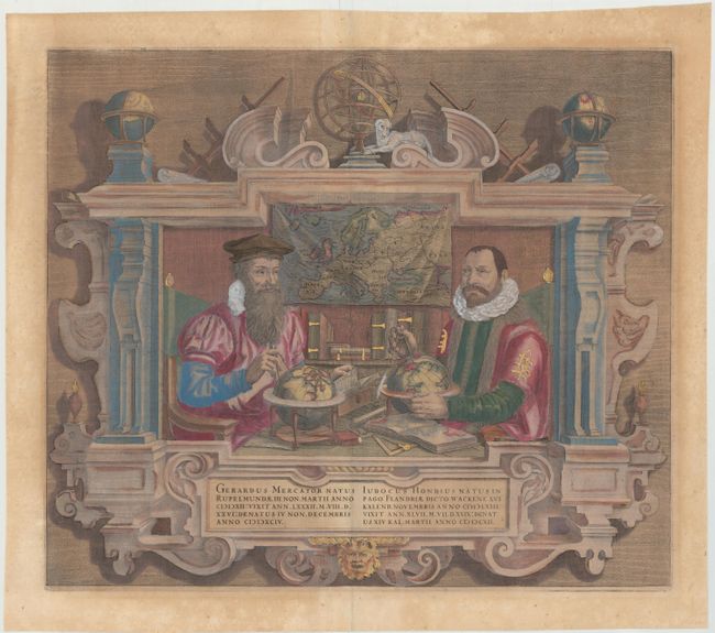
Auction 143, Lot 4
Subject: Title Pages - Portraits
Hondius
Gerardus Mercator … Iudocus Hondius …, 1638
Size: 17.3 x 14.8 inches (43.9 x 37.6 cm)
Estimate: $2,200 - $2,500
Sold for: $1,600
Closed on 2/13/2013
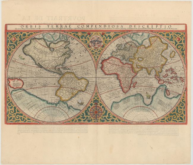
Auction 143, Lot 17
Subject: World
Mercator, Rumold
Orbis Terrae Compendiosa Descriptio, 1587
Size: 20.6 x 11.4 inches (52.3 x 29 cm)
Estimate: $6,000 - $8,000
Mercator's Double-Hemisphere World Map
Sold for: $3,500
Closed on 2/13/2013
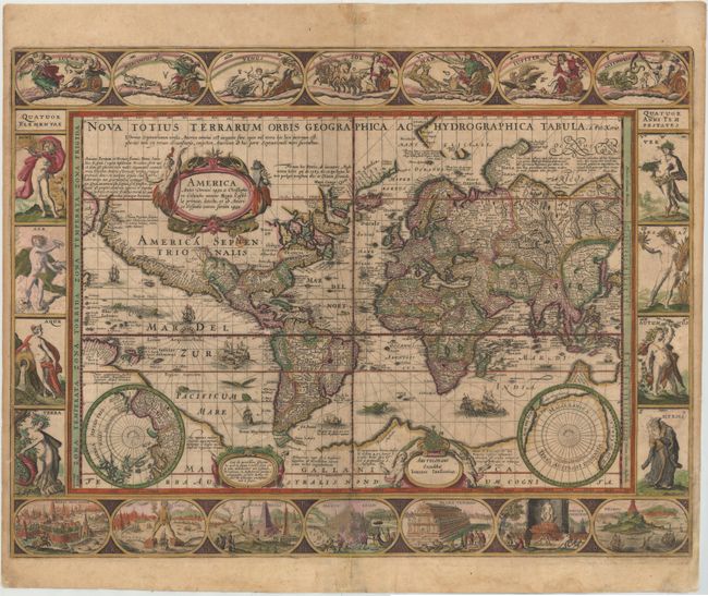
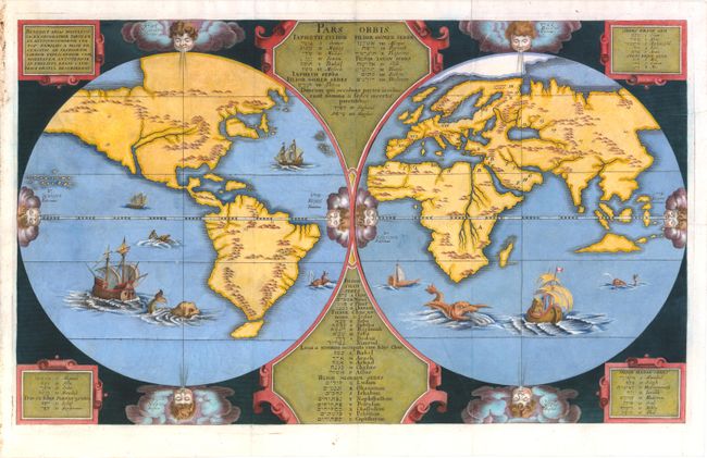
Auction 143, Lot 20
Subject: World
Kaerius/Jansson
Nova Totius Terrarum Orbis Geographica ac Hydrographica Tabula, 1630
Size: 21.3 x 15.8 inches (54.1 x 40.1 cm)
Estimate: $14,000 - $16,000
Sold for: $8,500
Closed on 2/13/2013
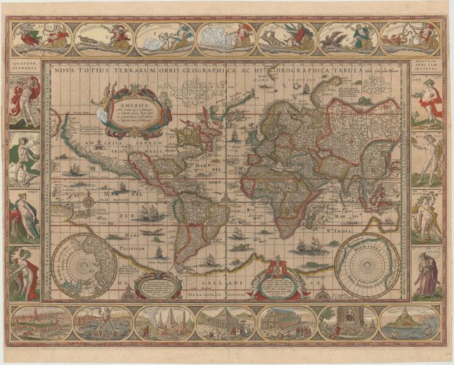
Auction 143, Lot 21
Subject: World
Blaeu, Willem
Nova Totius Terrarum Orbis Geographica ac Hydrographica Tabula, 1635
Size: 21.5 x 16.2 inches (54.6 x 41.1 cm)
Estimate: $15,000 - $18,000
Blaeu's Magnificent Carte-a-Figures World Map
Sold for: $10,000
Closed on 2/13/2013
Auction 143, Lot 23
Subject: World
Arias Montanus, Benito
Benedict Arias Montanus Sacrae Geographiae Tabulam ex Antiquissimorum Cultor. Familiis a Mose Recensitis…, 1660
Size: 20.5 x 12.3 inches (52.1 x 31.2 cm)
Estimate: $6,500 - $7,000
Unsold
Closed on 2/13/2013
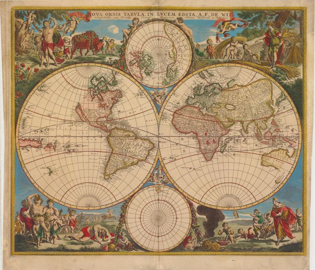
Auction 143, Lot 25
Subject: World
Wit, Frederick de
Nova Orbis Tabula, in Lucem Edita, 1670
Size: 22.3 x 18.8 inches (56.6 x 47.8 cm)
Estimate: $4,000 - $5,000
De Wit's Stunning Double-Hemisphere Map
Sold for: $3,500
Closed on 2/13/2013
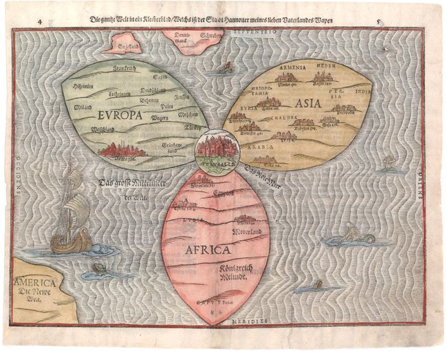
Auction 143, Lot 56
Subject: Ancient World
Bunting, Heinrich
Die Gantze Welt in ein Kleeberblat / Welchs ist der Stadt Hannover Meines Lieben Vaterlandes Wapen, 1581
Size: 14.3 x 10.7 inches (36.3 x 27.2 cm)
Estimate: $5,500 - $6,500
Bunting's Clover Leaf Map of the Old World
Sold for: $3,500
Closed on 2/13/2013

Auction 143, Lot 58
Subject: Ancient World
Macrobius, Ambrosius Aurelius Theodo
Macrobii Ambrosii Aurelii Theodosii, uiri Consularis, et Illustris, In Somnium Scipionis, Lib. II. Saturnaliorum. Lib. VII…, 1597
Size: 3.5 x 5 inches (8.9 x 12.7 cm)
Estimate: $1,500 - $1,700
Macrobius' Miniature Ancient World Map
Sold for: $1,000
Closed on 2/13/2013
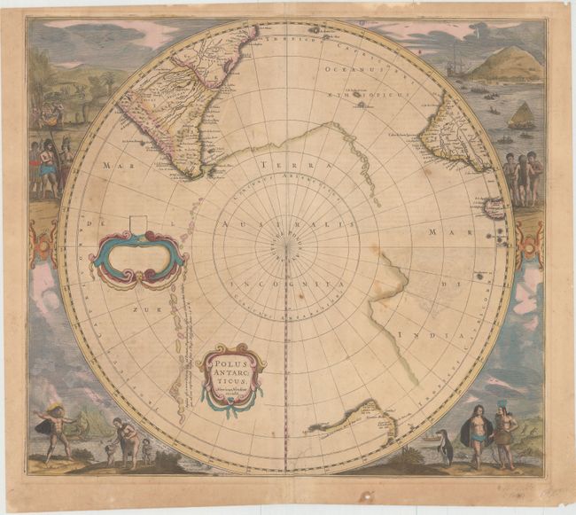
Auction 143, Lot 69
Subject: South Pole
Hondius, Henricus
Polus Antarcticus, 1641
Size: 19.5 x 17 inches (49.5 x 43.2 cm)
Estimate: $1,600 - $2,000
Sold for: $1,100
Closed on 2/13/2013

Auction 143, Lot 71
Subject: Celestial
Schenk, Pieter
Planisphaerium Coeleste, 1705
Size: 22 x 19 inches (55.9 x 48.3 cm)
Estimate: $1,800 - $2,400
Sold for: $1,300
Closed on 2/13/2013

Auction 143, Lot 72
Subject: Celestial
Ottens, Reiner and Joshua
Sterre Kaert of Hemels Pleyn, Waer door men Kan Wete Hoe Laet..., 1756
Size: 22.8 x 18.5 inches (57.9 x 47 cm)
Estimate: $2,000 - $2,200
Unsold
Closed on 2/13/2013

Auction 143, Lot 75
Subject: Solar System
Cellarius, Andreas
Planisphaerium Ptolemaicum, sive Machina Orbium Mundi ex Hypothesi Ptolemaica in Plano Disposita, 1661
Size: 20.8 x 17.5 inches (52.8 x 44.5 cm)
Estimate: $2,750 - $3,750
Ptolemy's Earth-Centric Model of the Solar System
Sold for: $2,000
Closed on 2/13/2013

Auction 143, Lot 79
Subject: Globes
Joslin, Gilman
[12-inch Terrestrial Globe] Loring's Terrestrial Globe Containing all the Late Discoveries and Geographical Improvements, also the Tracks of the Most Celebrated Circumnavigators, 1851
Size: 16 x 18 inches (40.6 x 45.7 cm)
Estimate: $7,500 - $10,000
Sold for: $4,500
Closed on 2/13/2013

Auction 143, Lot 81
Subject: Globes
Goldthwaites Handy Patent Folding Globe the Most Valuable & Best Globe Made, 1902
Size: 12 x 24 inches (30.5 x 61 cm)
Estimate: $500 - $700
Fascinating and Unusual Umbrella Globe
Sold for: $900
Closed on 2/13/2013

Auction 143, Lot 82
Subject: Globes
[20-Inch French Terrestrial Globe], 1936
Size: 24 x 35.4 inches (61 x 89.9 cm)
Estimate: $7,000 - $9,000
Unusual Early 20th Century Art Deco Globe
Unsold
Closed on 2/13/2013

Auction 143, Lot 91
Subject: Western Hemisphere
Ortelius, Abraham
Americae sive Novi Orbis, Nova Descriptio, 1587
Size: 19.3 x 14 inches (49 x 35.6 cm)
Estimate: $6,000 - $7,000
Ortelius' Influential Map of the New World - Full Original Color
Unsold
Closed on 2/13/2013

Auction 143, Lot 94
Subject: Western Hemisphere
Speed, John
America with those Known Parts in that Unknowne Worlde Both People and Manner of Buildings Discribed and Inlarged, 1626
Size: 20 x 15.5 inches (50.8 x 39.4 cm)
Estimate: $5,500 - $6,500
Sold for: $3,000
Closed on 2/13/2013
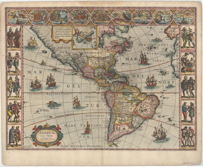
Auction 143, Lot 95
Subject: Western Hemisphere
Blaeu, Willem
Americae Nova Tabula, 1631
Size: 21.5 x 16.1 inches (54.6 x 40.9 cm)
Estimate: $6,000 - $7,000
Blaeu's Stunning Carte-a-Figures Map of the Americas
Sold for: $5,500
Closed on 2/13/2013
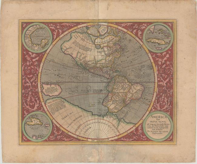
Auction 143, Lot 96
Subject: Western Hemisphere - America
Mercator, Michael
America sive India Nova ad Magnae Gerardi Mercatoris aui Universalis Imitationem in Compendium Redacta, 1633
Size: 18 x 14.5 inches (45.7 x 36.8 cm)
Estimate: $4,250 - $5,500
Unsold
Closed on 2/13/2013

Auction 143, Lot 97
Subject: Western Hemisphere
Anon.
America Noviter Delineata Auct: Judoco Hondio, 1659
Size: 21.5 x 16.2 inches (54.6 x 41.1 cm)
Estimate: $4,000 - $5,500
Very Rare Derivative of Hondius' Map of the Americas
Sold for: $2,500
Closed on 2/13/2013
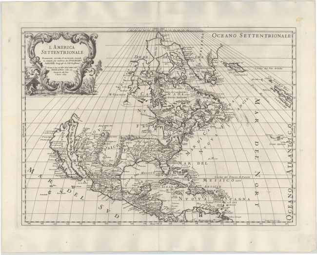
Auction 143, Lot 99
Subject: North America
Rossi, Giamcomo Giovanni
L'America Settentrionale, 1687
Size: 21.5 x 15.5 inches (54.6 x 39.4 cm)
Estimate: $2,500 - $3,500
Unsold
Closed on 2/13/2013
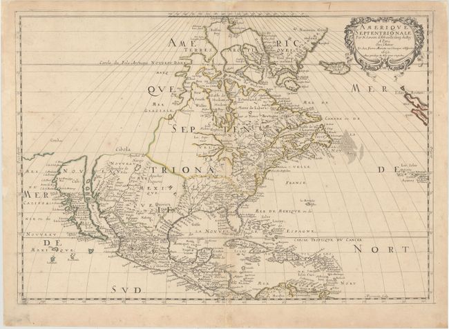
Auction 143, Lot 115
Subject: North America
Sanson/Mariette
Amerique Septentrionale par N. Sanson d'Abbeville…, 1650
Size: 22 x 15.5 inches (55.9 x 39.4 cm)
Estimate: $3,000 - $4,000
Sold for: $2,200
Closed on 2/13/2013
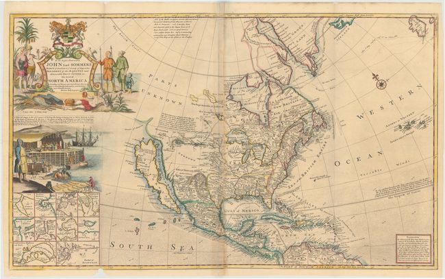
Auction 143, Lot 119
Subject: North America
Moll, Herman
To The Right Honourable John Lord Sommers... This Map of North America According to ye Newest and Most Exact Observations, 1720
Size: 38.1 x 22.8 inches (96.8 x 57.9 cm)
Estimate: $5,500 - $7,000
Moll's Famous "Codfish Map" of North America
Sold for: $4,000
Closed on 2/13/2013

Auction 143, Lot 122
Subject: North America
Anville, Jean Baptiste Bourguignon d'
Amerique Septentrionale Publiee sous les Auspices de Monseigneur le Duc d'Orleans..., 1746
Size: 34.1 x 32.7 inches (86.6 x 83.1 cm)
Estimate: $2,000 - $2,400
Unsold
Closed on 2/13/2013

Auction 143, Lot 123
Subject: North America
Laurie & Whittle
A New Map of North America; with the West India Islands. Divided According to the Preliminary Articles of Peace, Signed at Versailles, 20, Jan. 1783, 1794
Size: 45.7 x 39.5 inches (116.1 x 100.3 cm)
Estimate: $2,400 - $3,000
Sold for: $1,800
Closed on 2/13/2013
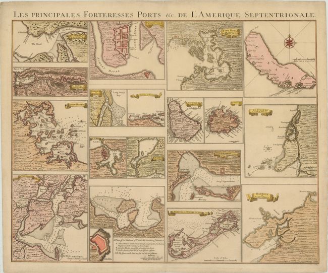
Auction 143, Lot 136
Subject: North American Cities - New York, Boston, Charleston
Popple/Covens & Mortier
Les Principales Forteresses Ports &c. de l'Amerique Septentrionale, 1741
Size: 24.2 x 19.2 inches (61.5 x 48.8 cm)
Estimate: $2,000 - $2,400
Sold for: $1,200
Closed on 2/13/2013
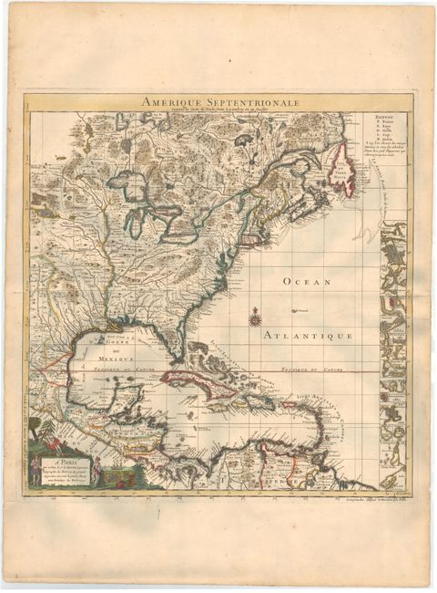
Auction 143, Lot 139
Subject: Colonial North America & West Indies
Popple/Le Rouge
Amerique Septentrionale suivant la Carte de Pople…, 1742
Size: 19.3 x 20 inches (49 x 50.8 cm)
Estimate: $2,200 - $2,750
Sold for: $1,600
Closed on 2/13/2013
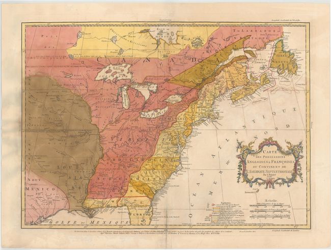
Auction 143, Lot 154
Subject: Colonial United States & Canada
Palairet, Jean
Carte des Possessions Angloises & Francoises du Continent de l'Amerique Septentrionale, 1756
Size: 22.5 x 16.7 inches (57.2 x 42.4 cm)
Estimate: $2,000 - $2,400
Sold for: $1,400
Closed on 2/13/2013
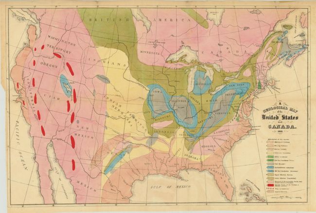
Auction 143, Lot 163
Subject: Canada & United States
Hitchcock, Edward
[Lot of 2] A Geological Map of the United States and Canada [and] Outline of the Geology of the Globe, 1853
Size: See Description
Estimate: $1,000 - $1,300
Sold for: $950
Closed on 2/13/2013
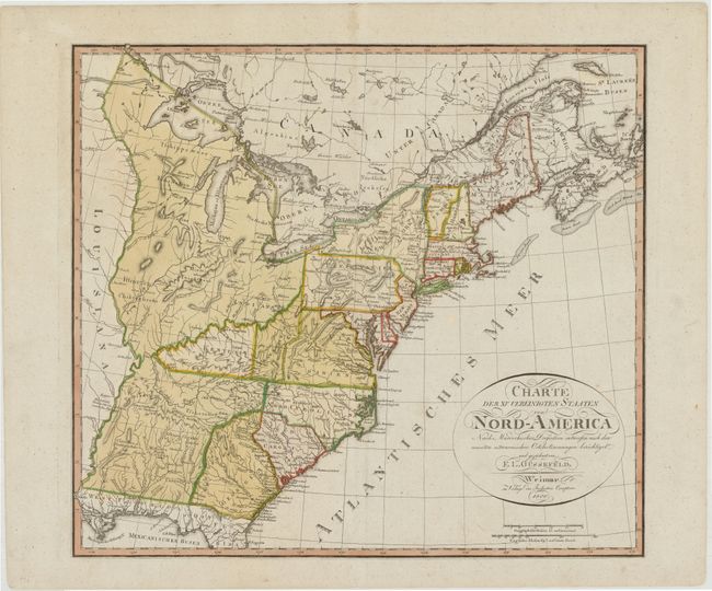
Auction 143, Lot 181
Subject: Eastern United States, Franklinia
Gussefeld, Franz Ludwig
Charte der XV Vereinigten Staaten von Nord-America…, 1800
Size: 20.5 x 18.3 inches (52.1 x 46.5 cm)
Estimate: $1,400 - $1,600
Map Depicting the Proposed State of Franklin
Sold for: $2,500
Closed on 2/13/2013
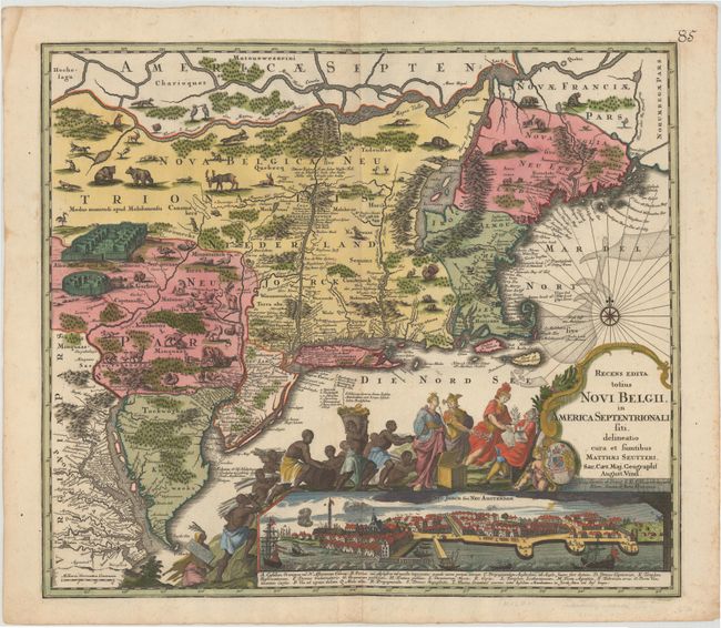
Auction 143, Lot 185
Subject: Colonial New England & Mid-Atlantic
Seutter, Matthias
Recens Edita totius Novi Belgii, in America Septentrionali siti, delineatio cura et Sumtibus, 1730
Size: 22.5 x 19.5 inches (57.2 x 49.5 cm)
Estimate: $4,000 - $4,750
Sold for: $3,250
Closed on 2/13/2013
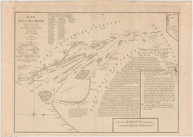
Auction 143, Lot 194
Subject: Colonial Mid-Atlantic, Delaware Bay
Le Rouge, George Louis
Baye de la Delaware avec les Ports, Sondes, Dangers, Bancs &c. depuis les Caps Jusqu'a Philadelphie…, 1777
Size: 25.8 x 19 inches (65.5 x 48.3 cm)
Estimate: $2,000 - $2,400
The Most Accurate Chart of Delaware Bay in the 18th Century
Unsold
Closed on 2/13/2013
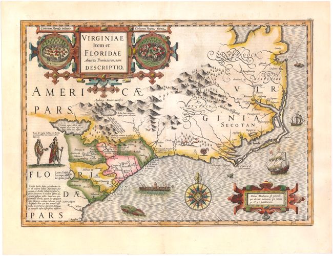
Auction 143, Lot 196
Subject: Colonial Southeast
Hondius, Jodocus
Virginiae Item et Floridae Americae Provinciarum, Nova Descriptio, 1628
Size: 19.1 x 13.5 inches (48.5 x 34.3 cm)
Estimate: $2,400 - $3,000
A Seminal Map of the Southeast and Early American Cartography
Sold for: $2,000
Closed on 2/13/2013
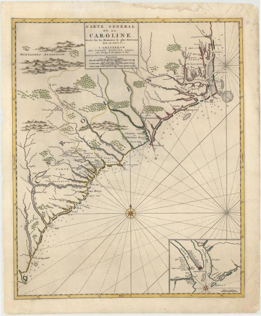
Auction 143, Lot 197
Subject: Colonial Southeast, North Carolina, South Carolina
Mortier, Pierre
Carte General de la Caroline Dresse sur les Memoires le Plus Nouveaux..., 1700
Size: 18.3 x 22.2 inches (46.5 x 56.4 cm)
Estimate: $3,250 - $4,000
Sold for: $2,100
Closed on 2/13/2013
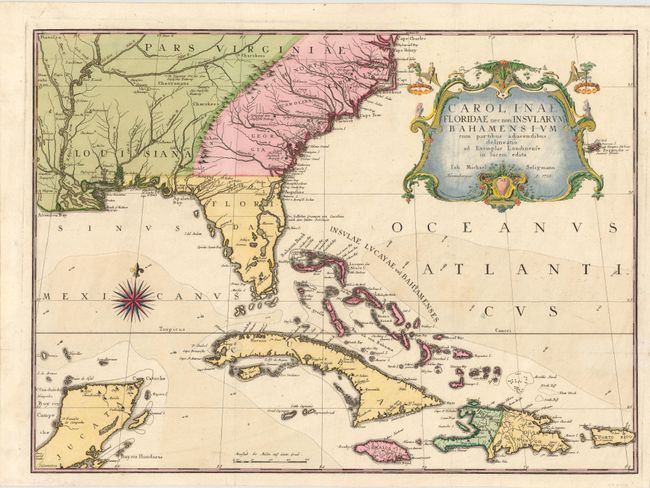
Auction 143, Lot 199
Subject: Colonial Southeast & Bahamas
Seligmann, Johann Michael
Carolinae Floridae nec non Insularum Bahamensium…, 1755
Size: 23 x 16.8 inches (58.4 x 42.7 cm)
Estimate: $5,500 - $6,500
Very Scarce and Important Map of the Southeastern United States
Sold for: $3,750
Closed on 2/13/2013
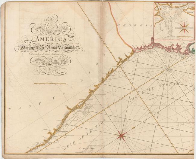
Auction 143, Lot 201
Subject: Southeast United States
Heather, William
[On 2 Sheets] A New Chart of America with the Harbors of Port Royal, Savannah &c, 1799
Size: 30.5 x 24.7 inches (77.5 x 62.7 cm)
Estimate: $4,000 - $6,000
A Remarkable Sea Chart of the Southeastern Coast
Sold for: $3,000
Closed on 2/13/2013
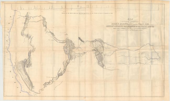
Auction 143, Lot 216
Subject: Western United States
Fremont/Preuss
[Lot of 2] Map of an Exploring Expedition to the Rocky Mountains in the Year 1842 and to Oregon & North California in the Years 1843-44 [and] Report of The Exploring Expedition to the Rocky Mountains…, 1845
Size: 51 x 30.5 inches (129.5 x 77.5 cm)
Estimate: $2,300 - $2,750
Sold for: $1,300
Closed on 2/13/2013
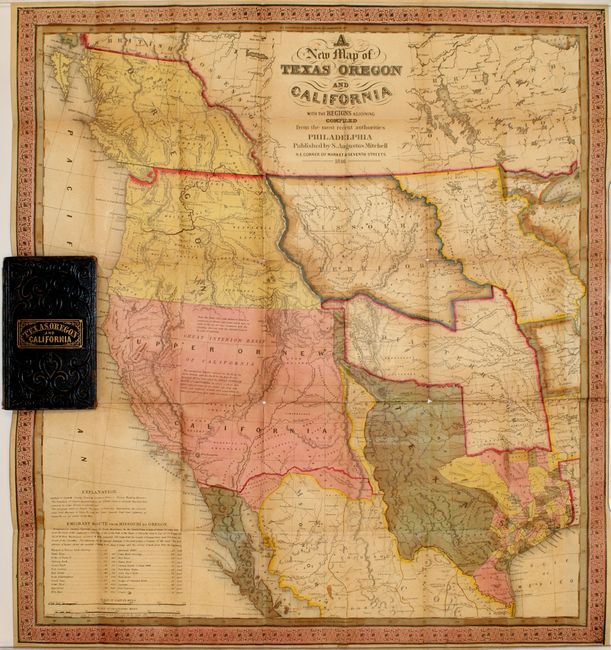
Auction 143, Lot 218
Subject: Western United States
Mitchell, Samuel Augustus
A New Map of Texas Oregon and California, 1846
Size: 19 x 21 inches (48.3 x 53.3 cm)
Estimate: $9,000 - $11,000
Mitchell's Famous Map Showing the New State of Texas
Sold for: $6,500
Closed on 2/13/2013
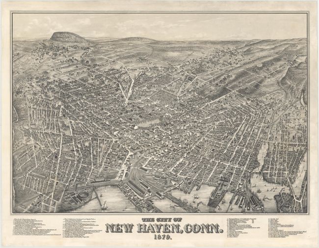
Auction 143, Lot 231
Subject: New Haven, Connecticut
Bailey, O. H. & Co.
The City of New Haven, Conn. 1879., 1879
Size: 37.4 x 25.7 inches (95 x 65.3 cm)
Estimate: $8,000 - $9,000
Extremely Rare View of New Haven and Yale College
Unsold
Closed on 2/13/2013
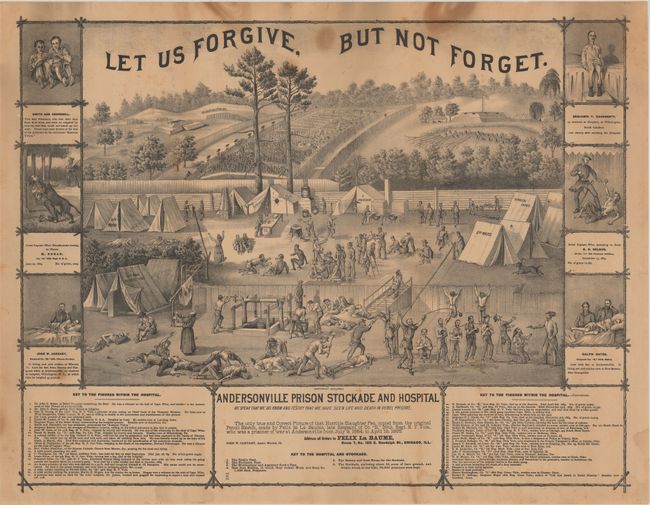
Auction 143, Lot 239
Subject: Georgia, Civil War
Andersonville Prison Stockade and Hospital, 1870
Size: 25.5 x 19.5 inches (64.8 x 49.5 cm)
Estimate: $300 - $400
Fascinating Civil War Scene
Sold for: $250
Closed on 2/13/2013
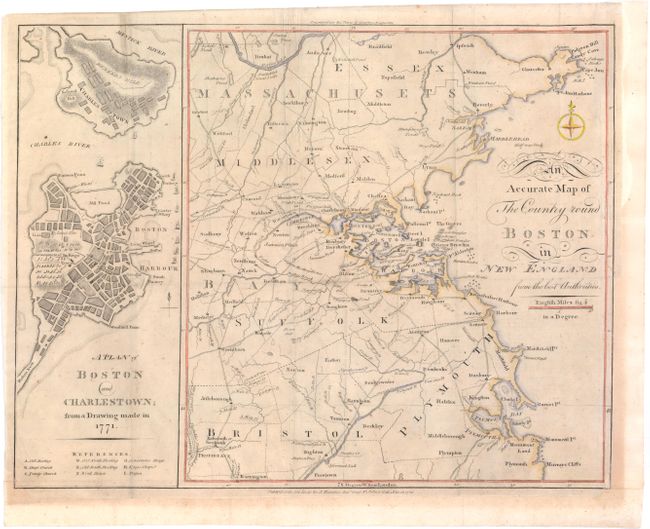
Auction 143, Lot 260
Subject: Boston, Massachusetts
Anon.
An Accurate Map of The Country round Boston in New England from the best Authorities [on sheet with] A Plan of Boston and Charlestown; from a Drawing made on 1771, 1776
Size: 16.3 x 12.3 inches (41.4 x 31.2 cm)
Estimate: $1,100 - $1,400
Uncommon Revolutionary War Map
Sold for: $550
Closed on 2/13/2013
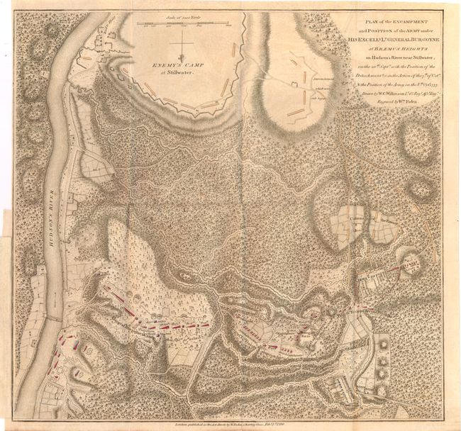
Auction 143, Lot 270
Subject: Colonial New York, Revolutionary War
Faden, William
Plan of the Encampment and Position of the Army under his Excelly. Lt. General Burgoyne at Braemus Heights on Hudson's River near Stillwater..., 1780
Size: 13.9 x 13.3 inches (35.3 x 33.8 cm)
Estimate: $1,400 - $1,700
Important Revolutionary War Map
Sold for: $700
Closed on 2/13/2013
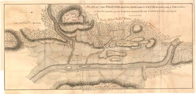
Auction 143, Lot 271
Subject: Colonial New York, Revolutionary War
Faden, William
Plan of the Position which the Army under Lt. Genl. Burgoine Took at Saratoga on the 10th of September 1777..., 1780
Size: 18.8 x 8.5 inches (47.8 x 21.6 cm)
Estimate: $1,500 - $1,800
Important Revolutionary War Map
Sold for: $1,100
Closed on 2/13/2013
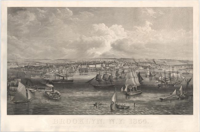
Auction 143, Lot 278
Subject: Brooklyn, New York
Brooklyn. N.Y. 1854, 1854
Size: 41 x 23.8 inches (104.1 x 60.5 cm)
Estimate: $6,000 - $7,000
Rare, Early View of Brooklyn
Sold for: $3,250
Closed on 2/13/2013
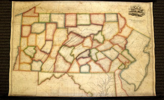
Auction 143, Lot 285
Subject: Pennsylvania
Melish, John
Map of Pennsylvania, Constructed from the County Surveys Authorized by the State; and other Original Documents...Corrected & Improved to 1826, 1826
Size: 73.5 x 42.5 inches (186.7 x 108 cm)
Estimate: $13,500 - $15,000
Melish's Greatest Published Work
Unsold
Closed on 2/13/2013
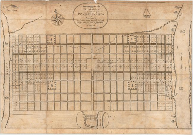
Auction 143, Lot 287
Subject: Philadelphia, Pennsylvania
Holme, Thomas
A Portraiture of the City of Philadelphia in the Province of Pennsylvania in America [with] Ordinances of the Corporation of the City of Philadelphia…, 1812
Size: 5.6 x 9 inches (14.2 x 22.9 cm)
Estimate: $4,000 - $5,000
One of the Most Important Plans of a Colonial North American City
Sold for: $2,100
Closed on 2/13/2013
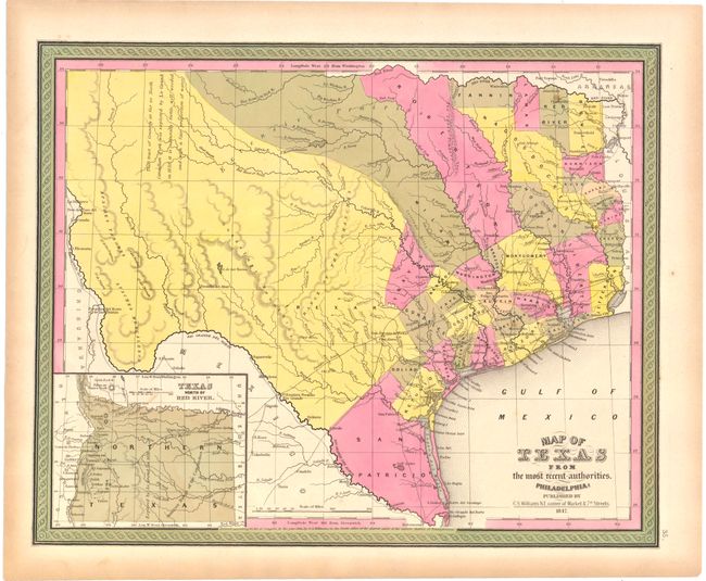
Auction 143, Lot 291
Subject: Texas
Williams, C. S.
Map of Texas from the Most Recent Authorities, 1847
Size: 14.5 x 12 inches (36.8 x 30.5 cm)
Estimate: $1,000 - $1,300
Sold for: $750
Closed on 2/13/2013

Auction 143, Lot 410
Subject: Atlantic Ocean
Jefferys/Sayer & Bennett
The Atlantic Ocean by Governor Pownall F.R.S., 1787
Size: 25 x 19.3 inches (63.5 x 49 cm)
Estimate: $1,200 - $1,500
Sold for: $1,400
Closed on 2/13/2013
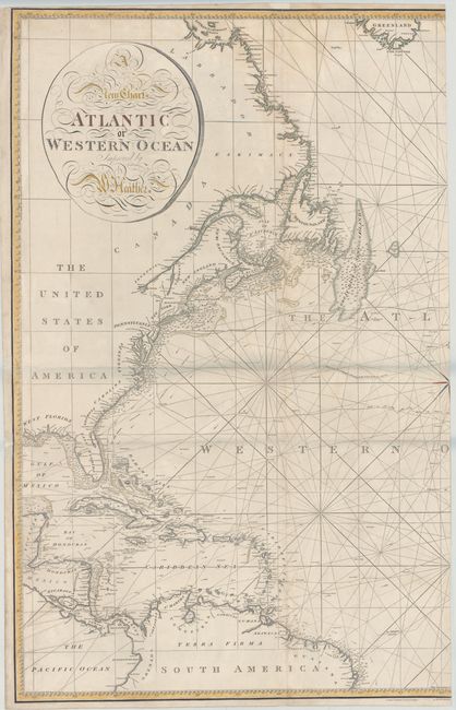
Auction 143, Lot 411
Subject: North Atlantic Ocean
Heather, William
[On 2 Sheets] A New Chart of the Atlantic or Western Ocean, 1814
Size: 24.9 x 37 inches (63.2 x 94 cm)
Estimate: $2,000 - $2,300
Sold for: $1,500
Closed on 2/13/2013
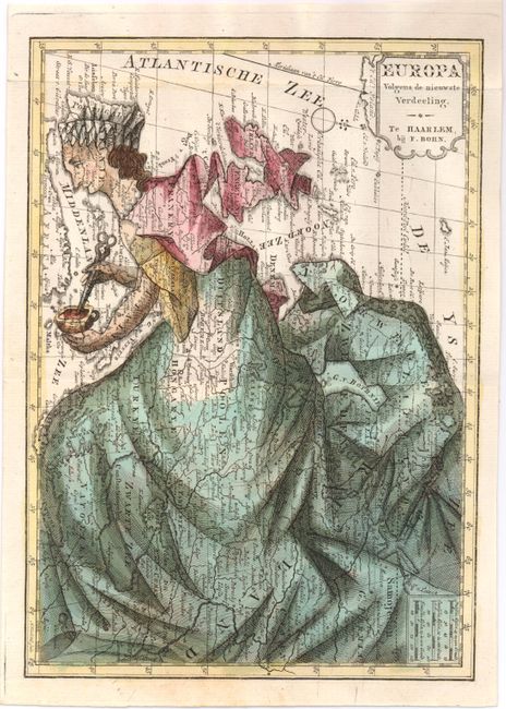
Auction 143, Lot 429
Subject: Europe
Bohn, Francois
Europa Volgens de Nieuwste Verdeeling, 1794
Size: 6.5 x 9.2 inches (16.5 x 23.4 cm)
Estimate: $1,000 - $1,200
Unsold
Closed on 2/13/2013
79 lots
Page 1 of 2