Showing Featured Lots(remove filter)
Showing results for:Auction 139
Catalog Archive
82 lots
Page 1 of 2
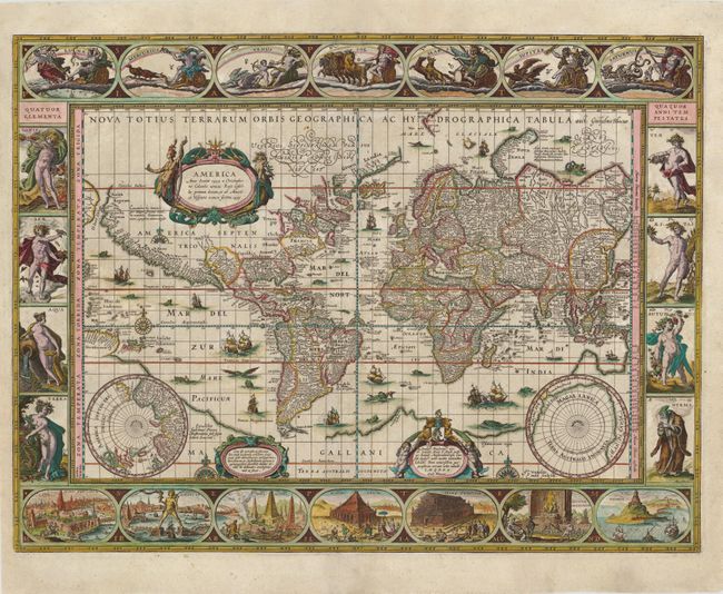
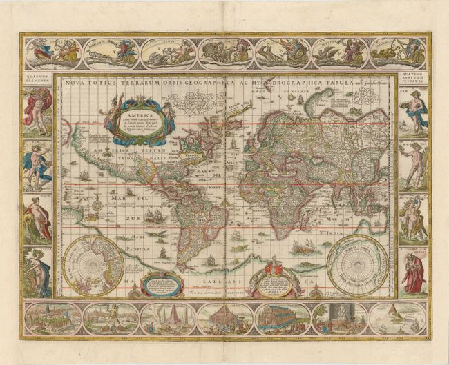
Auction 139, Lot 16
Subject: World & Continents
Blaeu, Willem
[Lot of 5] Nova Totius Terrarum Orbis Geographica ac Hydrographica Tabula [and] Americae Nova Tabula [and] Africae Nova Descriptio [and] Asia Noviter Delineata… [and] Europa Recens Descripta, 1630
Size: 21.3 x 16 inches (54.1 x 40.6 cm)
Estimate: $47,000 - $55,000
Set of Blaeu World and Continents with Extremely Rare Blank Versos
Sold for: $34,000
Closed on 2/15/2012
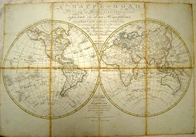
Auction 139, Lot 17
Subject: World & Continents
Herisson, Eustache
La Mappe-Monde [and] Carte Generale de L'Europe [and] Carte Generale de L'Asie [and] Carte Generale de L'Afrique [and] Carte Generale de L'Amerique, 1809-17
Size: 12 x 16 inches (30.5 x 40.6 cm)
Estimate: $1,400 - $1,800
Book of Maps of Captain Cook's Voyages
Sold for: $1,000
Closed on 2/15/2012
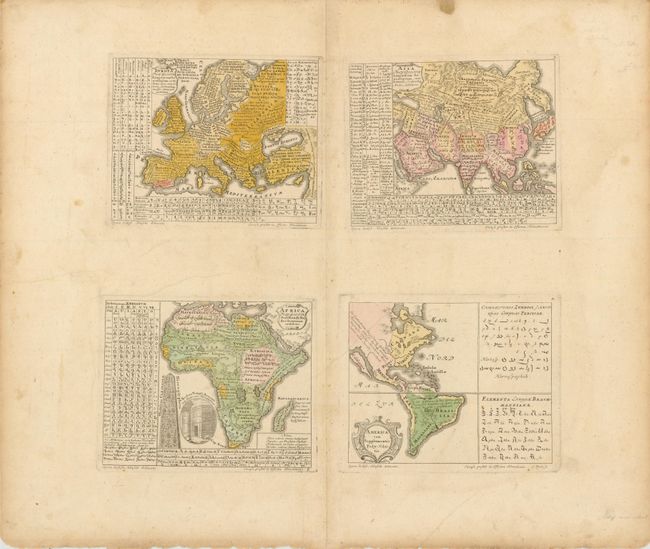
Auction 139, Lot 19
Subject: Continents
Homann Heirs
Europa Poly Glotta… [on sheet with] Asia Poly-Glotta… [and] America cum Supplementis Poly-Glottis [and] Africa Poly-Glotta, 1741
Size: 16.8 x 15 inches (42.7 x 38.1 cm)
Estimate: $1,100 - $1,400
Sold for: $650
Closed on 2/15/2012
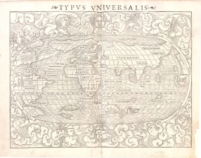
Auction 139, Lot 20
Subject: World
Munster, Sebastian
Typus Universalis, 1545
Size: 13.5 x 10.3 inches (34.3 x 26.2 cm)
Estimate: $6,000 - $8,000
First State of Munster's World Map
Unsold
Closed on 2/15/2012
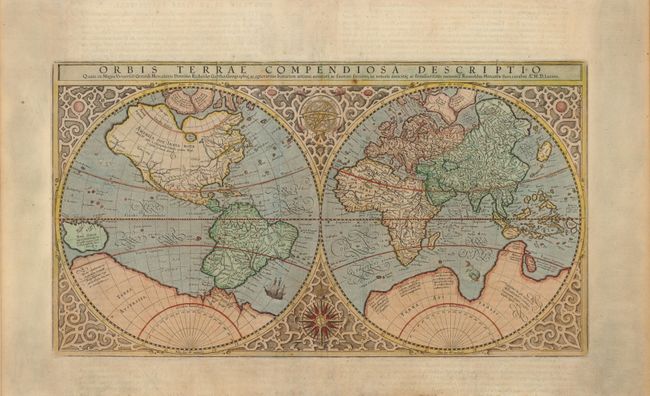
Auction 139, Lot 22
Subject: World
Mercator, Rumold
Orbis Terrae Compendiosa Descriptio, 1587
Size: 20.6 x 11.4 inches (52.3 x 29 cm)
Estimate: $5,000 - $7,000
Mercator's Double-Hemisphere World Map
Sold for: $3,750
Closed on 2/15/2012
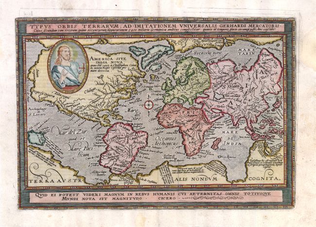
Auction 139, Lot 23
Subject: World
Quad, Matthias von Kinckelbach
Typus Orbis Terrarum, ad Imitationem Universalis Gerhardi Mercatoris…, 1597
Size: 12.3 x 8.5 inches (31.2 x 21.6 cm)
Estimate: $1,900 - $2,300
Sold for: $1,400
Closed on 2/15/2012
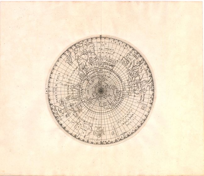
Auction 139, Lot 24
Subject: World
Ritter, Franz
[Untitled - World], 1613
Size: 9 x 9 inches (22.9 x 22.9 cm)
Estimate: $4,000 - $5,000
Ritter's Circular Sundial World Map
Unsold
Closed on 2/15/2012
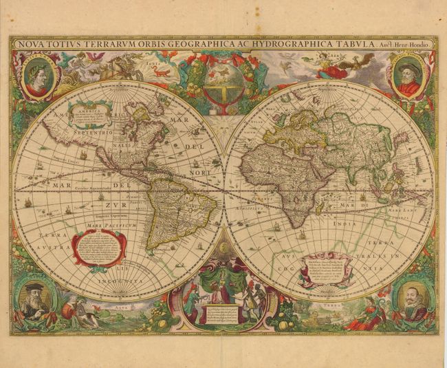
Auction 139, Lot 25
Subject: World
Hondius, Henricus
Nova Totius Terrarum Orbis Geographica ac Hydrographica Tabula, 1630
Size: 21 x 15 inches (53.3 x 38.1 cm)
Estimate: $12,000 - $15,000
Henricus Hondius' Baroque-Style World Map
Unsold
Closed on 2/15/2012
Auction 139, Lot 26
Subject: World
Blaeu, Willem
Nova Totius Terrarum Orbis Geographica ac Hydrographica Tabula, 1635
Size: 21.4 x 16 inches (54.4 x 40.6 cm)
Estimate: $20,000 - $24,000
Blaeu's Magnificent World Map
Sold for: $12,500
Closed on 2/15/2012
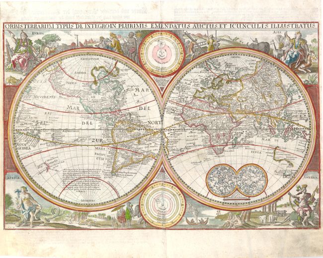
Auction 139, Lot 27
Subject: World
Visscher, Nicolas
Orbis Terrarum Typus de Integro in Plurimis Emendatus, Auctus, et Icunculis Illustratus, 1660
Size: 18.8 x 12.5 inches (47.8 x 31.8 cm)
Estimate: $2,300 - $2,750
Sold for: $1,500
Closed on 2/15/2012

Auction 139, Lot 29
Subject: World
Wit, Frederick de
Nova Orbis Tabula, in Lucem Edita, 1670
Size: 21.8 x 18.5 inches (55.4 x 47 cm)
Estimate: $4,750 - $6,000
De Wit's Stunning Double-Hemisphere Map
Sold for: $4,250
Closed on 2/15/2012
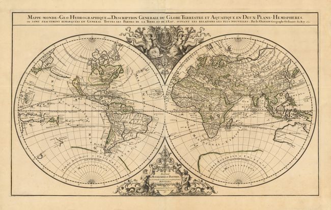
Auction 139, Lot 32
Subject: World
Jaillot, Alexis-Hubert
Mappe-Monde Geo-Hydrographique, ou Description Generale du Globe Terrestre et Aquatique en Deux Plans-Hemispheres…, 1691
Size: 35.3 x 21 inches (89.7 x 53.3 cm)
Estimate: $3,500 - $4,250
Unsold
Closed on 2/15/2012
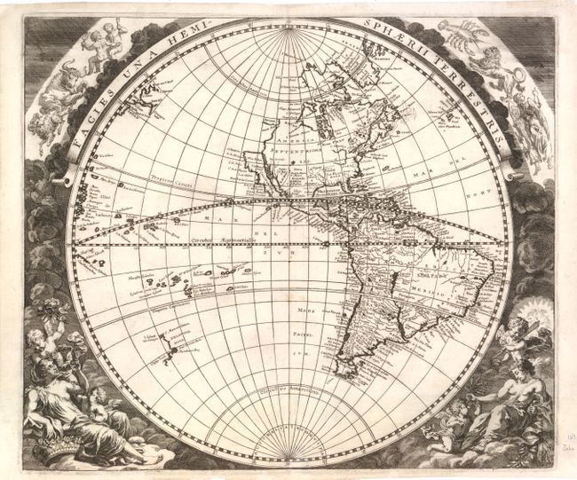
Auction 139, Lot 33
Subject: World
Zahn, Johannes
[Lot of 2] Facies Una Hemisphaerii Terrestris [and] Facies Altera Hemisphaerii Terrestris, 1696
Size: 16.5 x 14 inches (41.9 x 35.6 cm)
Estimate: $3,750 - $4,500
Unsold
Closed on 2/15/2012
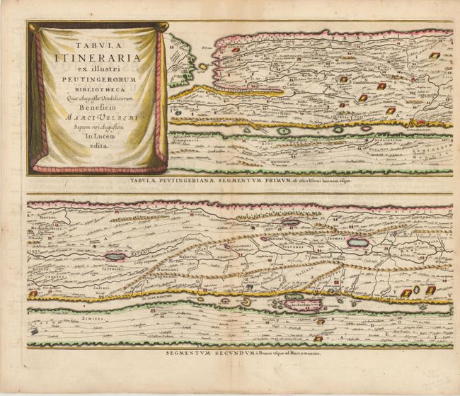
Auction 139, Lot 50
Subject: Ancient World
Jansson, Jan
Tabula Itineraria ex Illustri Peutingerorum Bibliotheca…, 1652
Size: 20 x 15.5 inches (50.8 x 39.4 cm)
Estimate: $3,000 - $3,750
Jansson's Famous Peutinger Table
Unsold
Closed on 2/15/2012
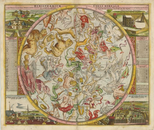
Auction 139, Lot 59
Subject: Celestial
Doppelmayr/Homann
Hemisphaerium Coeli Boreale in quo Fixarum Loca Secundum Eclipticae Ductum ad Anum 1730…, 1742
Size: 23 x 19.3 inches (58.4 x 49 cm)
Estimate: $1,500 - $1,800
Superb Celestial Chart
Sold for: $1,100
Closed on 2/15/2012
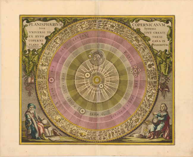
Auction 139, Lot 63
Subject: Solar System
Cellarius/Schenk & Valck
Planisphaerium Copernicanum sive Systema Universi Totius Creati ex Hypothesi Copernicana in Plano Exhibitum, 1708
Size: 20.8 x 17.5 inches (52.8 x 44.5 cm)
Estimate: $1,600 - $2,000
One of the Most Sought after Charts from this Famous Work
Sold for: $1,600
Closed on 2/15/2012
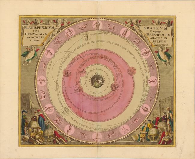
Auction 139, Lot 64
Subject: Solar System
Cellarius/Schenk & Valck
Planisphaerium Arateum sive Compages Orbium Mundanorum ex Hypothesi Aratea in Plano Expressa, 1708
Size: 20.8 x 17.5 inches (52.8 x 44.5 cm)
Estimate: $1,600 - $2,000
Sold for: $1,200
Closed on 2/15/2012
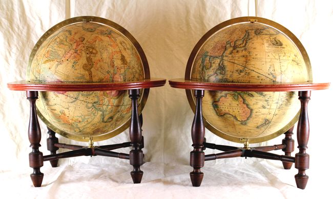
Auction 139, Lot 65
Subject: Globes
[Lot of 2 - Wilson & Sons Thirteen-Inch Terrestrial and Celestial Globes], 1831
Size: 18 x 18 inches (45.7 x 45.7 cm)
Estimate: $30,000 - $35,000
Exceptional Matched Pair of Wilson & Sons Globes
Sold for: $22,500
Closed on 2/15/2012
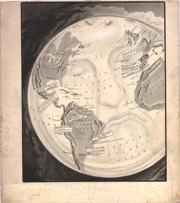
Auction 139, Lot 72
Subject: Cartographic Miscellany
Morrell, George
[World], 1910
Size: 12 x 15.3 inches (30.5 x 38.9 cm)
Estimate: $400 - $600
Sold for: $325
Closed on 2/15/2012
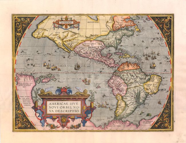
Auction 139, Lot 76
Subject: Western Hemisphere
Ortelius, Abraham
Americae sive Novi Orbis, Nova Descriptio, 1587
Size: 19 x 14 inches (48.3 x 35.6 cm)
Estimate: $6,000 - $7,000
Sold for: $4,500
Closed on 2/15/2012
Auction 139, Lot 77
Subject: Western Hemisphere
Hondius, Henricus
America Noviter Delineata, 1631
Size: 19.8 x 15 inches (50.3 x 38.1 cm)
Estimate: $2,000 - $2,400
Sold for: $1,700
Closed on 2/15/2012
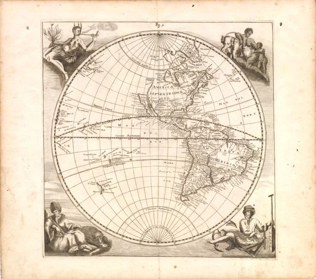
Auction 139, Lot 80
Subject: Western Hemisphere
Happel, Everard Werner
[Untitled - Western Hemisphere], 1687
Size: 11.3 x 11.5 inches (28.7 x 29.2 cm)
Estimate: $1,400 - $1,800
Unsold
Closed on 2/15/2012
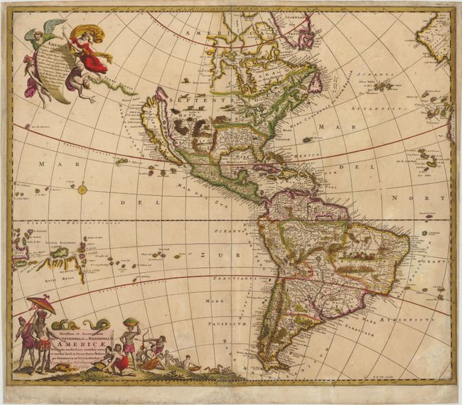
Auction 139, Lot 81
Subject: Western Hemisphere
Wit, Frederick de
Novissima et Accuratissima Septentrionalis ac Meridionalis Americae…, 1690
Size: 23 x 19.5 inches (58.4 x 49.5 cm)
Estimate: $1,200 - $1,600
Sold for: $900
Closed on 2/15/2012
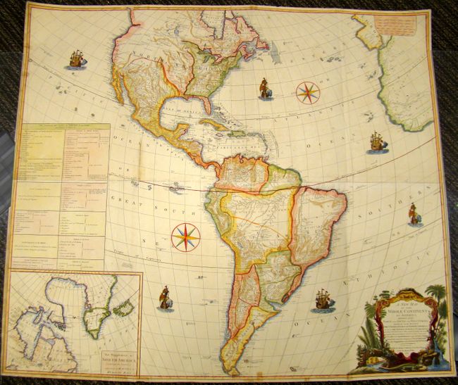
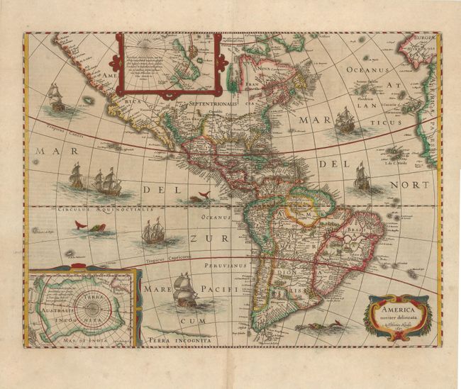
Auction 139, Lot 90
Subject: Western Hemisphere
Laurie & Whittle
A New Map of the Whole Continent of America. Divided into North and South and West Indies…, 1794
Size: 47 x 41 inches (119.4 x 104.1 cm)
Estimate: $1,500 - $2,000
Sold for: $1,100
Closed on 2/15/2012
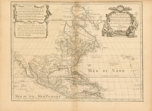
Auction 139, Lot 98
Subject: North America
Delisle, Guillaume
L'Amerique Septentrionale Dressee sur les Observations de Mrs. de l'Academie Royale des Sciences…, 1700
Size: 23.8 x 18 inches (60.5 x 45.7 cm)
Estimate: $2,000 - $2,500
Delisle's foundation map of North America
Sold for: $1,500
Closed on 2/15/2012
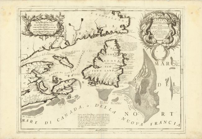
Auction 139, Lot 115
Subject: Eastern Canada
Coronelli, Vincenzo Maria
Canada Orientale nell'America Settentrionale…, 1695
Size: 24 x 18 inches (61 x 45.7 cm)
Estimate: $1,100 - $1,400
Unsold
Closed on 2/15/2012
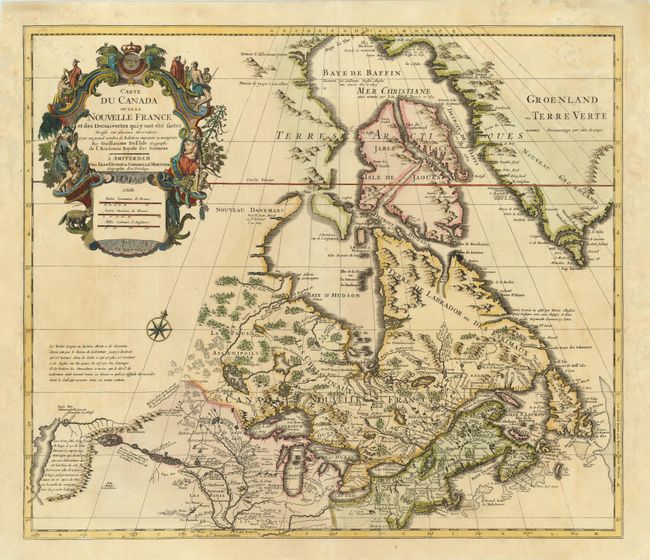
Auction 139, Lot 121
Subject: Colonial United States & Canada
Delisle/Covens & Mortier
Carte du Canada ou de la Nouvelle France et des Decouvertes qui y ont ete faites…, 1730
Size: 22.5 x 19.5 inches (57.2 x 49.5 cm)
Estimate: $1,300 - $1,600
One of the most influential maps of Canada, the Great Lakes and Upper Midwest
Sold for: $1,000
Closed on 2/15/2012
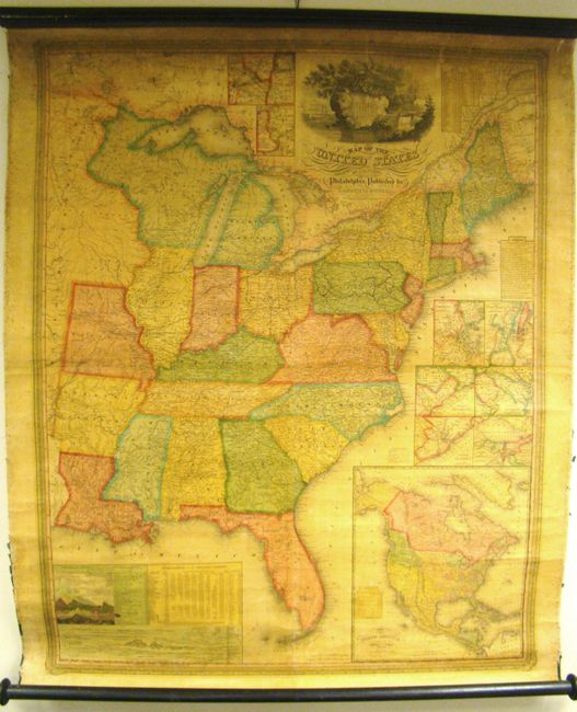
Auction 139, Lot 135
Subject: United States
Mitchell, Samuel Augustus
Map of the United States by J.H. Young, 1833
Size: 35 x 44 inches (88.9 x 111.8 cm)
Estimate: $1,000 - $1,500
Rare, Early Edition Mitchell Wall Map
Sold for: $1,200
Closed on 2/15/2012
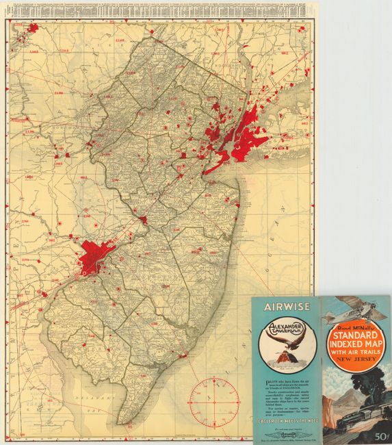
Auction 139, Lot 141
Subject: United States
Rand McNally & Co.
[Lot of 46] Rand McNally Standard Indexed Map with Air Trails, 1929-30
Size: 18.5 x 26 inches (47 x 66 cm)
Estimate: $1,600 - $2,000
Rare Rand McNally "Air Trails" Pocket Maps
Unsold
Closed on 2/15/2012
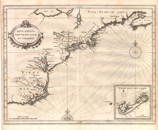
Auction 139, Lot 143
Subject: Colonial United States
Gerritsz/De Laet
Nova Anglia, Novum Belgium et Virginia, 1630
Size: 14 x 11 inches (35.6 x 27.9 cm)
Estimate: $5,000 - $7,000
A Map of Extreme Importance in the Cartographic Evolution of North America
Sold for: $3,750
Closed on 2/15/2012
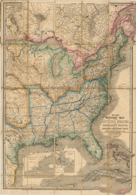
Auction 139, Lot 150
Subject: Eastern United States
Wyld, James
Wyld's Military Map of the United States, the Northern States, and the Southern Confederate States, with the Forts, Harbours, Arsenals, and Military Positions, 1861
Size: 23.3 x 35 inches (59.2 x 88.9 cm)
Estimate: $1,800 - $2,200
Important Civil War Map
Sold for: $1,300
Closed on 2/15/2012
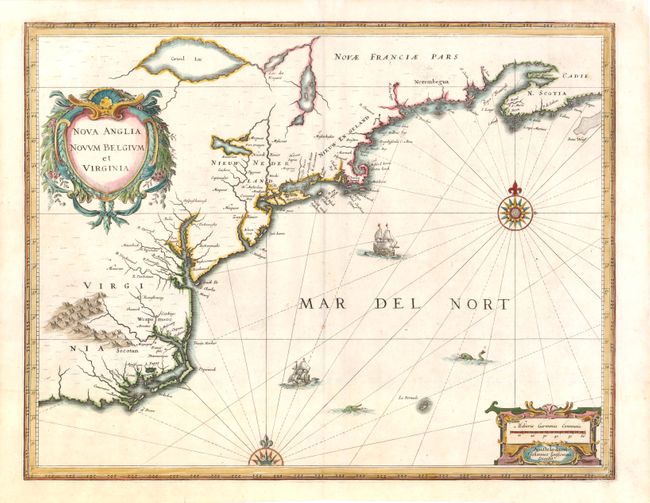
Auction 139, Lot 152
Subject: Colonial New England and Mid-Atlantic
Jansson, Jan
Nova Anglia Novum Belgium et Virginia, 1636
Size: 20 x 15.3 inches (50.8 x 38.9 cm)
Estimate: $2,100 - $2,400
Jansson's Influential Map of the East Coast
Sold for: $2,000
Closed on 2/15/2012
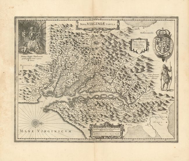
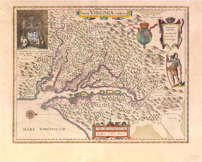
Auction 139, Lot 163
Subject: Colonial Mid-Atlantic
Hondius, Henricus
Nova Virginiae Tabula, 1630
Size: 19.5 x 15 inches (49.5 x 38.1 cm)
Estimate: $2,300 - $3,000
Unsold
Closed on 2/15/2012
Auction 139, Lot 164
Subject: Colonial Mid-Atlantic
Hondius/Blaeu
Nova Virginiae Tabula, 1640
Size: 19 x 14.8 inches (48.3 x 37.6 cm)
Estimate: $3,000 - $4,000
Sold for: $1,900
Closed on 2/15/2012
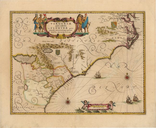
Auction 139, Lot 172
Subject: Colonial Southeast
Jansson, Jan
Virginiae Partis Australis, et Floridae Partis Orientalis, interjacentiumq Regionum Nova Descriptio, 1639
Size: 19.8 x 15.3 inches (50.3 x 38.9 cm)
Estimate: $1,600 - $1,800
Unsold
Closed on 2/15/2012
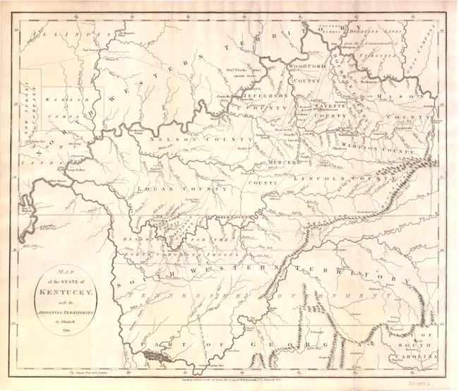
Auction 139, Lot 182
Subject: Kentucky and Tennessee
Russell, John C.
Map of the State of Kentucky; with the Adjoining Territories., 1794
Size: 17.8 x 15 inches (45.2 x 38.1 cm)
Estimate: $1,000 - $1,300
An Important Map of the Trans-Appalachian Frontier
Sold for: $950
Closed on 2/15/2012
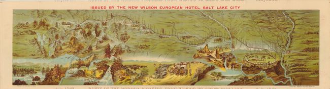
Auction 139, Lot 193
Subject: Central & Western United States - Utah
Route of the Mormon Pioneers from Nauvoo to Great Salt Lake, 1889
Size: 28.8 x 8.5 inches (73.2 x 21.6 cm)
Estimate: $500 - $650
Sold for: $300
Closed on 2/15/2012
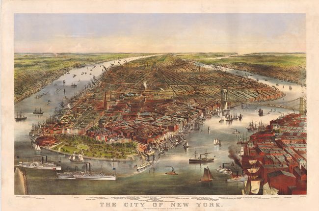
Auction 139, Lot 254
Subject: New York City, New York
Currier & Ives
The City of New York, 1870
Size: 32.8 x 22 inches (83.3 x 55.9 cm)
Estimate: $6,000 - $8,000
Fabulous View of the Brooklyn Bridge Prior to its Completion
Sold for: $11,000
Closed on 2/15/2012
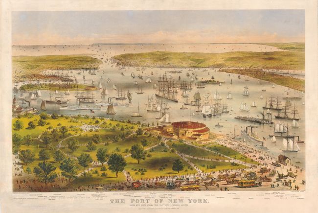
Auction 139, Lot 255
Subject: New York City, New York
Currier & Ives
The Port of New York, Bird's Eye View from the Battery Looking South, 1872
Size: 33 x 22 inches (83.8 x 55.9 cm)
Estimate: $6,000 - $8,000
Breathtaking Folio-Size Currier & Ives View of New York Harbor
Sold for: $4,000
Closed on 2/15/2012
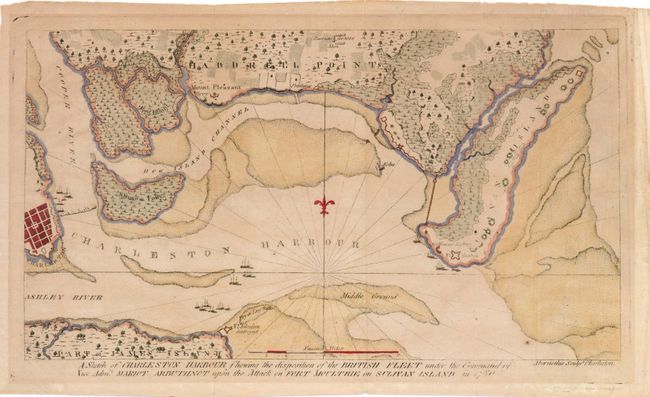
Auction 139, Lot 265
Subject: Charleston, South Carolina
Ramsay, David
A Sketch of Charleston Harbour Shewing the Disposition of the British Fleet under the Command of Vice Adm. Mariot Arbuthnot upon the Attack on Fort Moultrie on Sulivan Island in 1780, 1785
Size: 11.8 x 6.5 inches (30 x 16.5 cm)
Estimate: $1,200 - $1,500
Scarce Map of Charleston and the Battle at Fort Sullivan
Sold for: $700
Closed on 2/15/2012
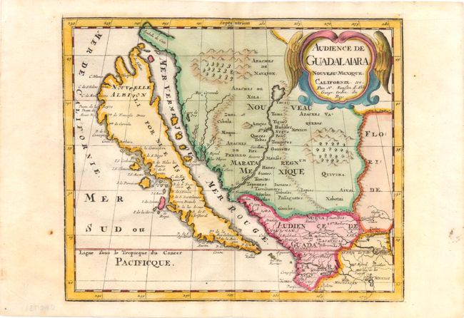
Auction 139, Lot 284
Subject: United States & Mexico, California
Sanson, Nicolas
Audience de Guadalaiara, Nouveau Mexique, Californie, &c., 1715
Size: 9.3 x 7.8 inches (23.6 x 19.8 cm)
Estimate: $1,000 - $1,200
Unsold
Closed on 2/15/2012
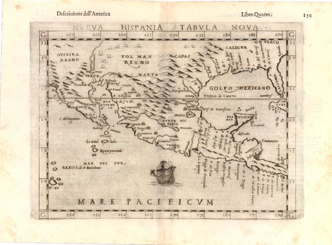
Auction 139, Lot 285
Subject: Southwest United States & Mexico
Ruscelli, Girolamo
Nueva Hispania Tabula Nova, 1598
Size: 9.8 x 7.5 inches (24.9 x 19.1 cm)
Estimate: $1,300 - $1,600
A Foundation Map for the American Southwest
Sold for: $950
Closed on 2/15/2012
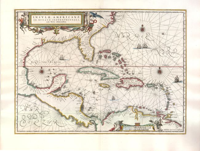
Auction 139, Lot 307
Subject: Gulf of Mexico and Caribbean
Jansson, Jan
Insulae Americanae in Oceano Septentrionali, cum Terris Adiacentibus, 1644
Size: 20.5 x 15 inches (52.1 x 38.1 cm)
Estimate: $1,400 - $1,700
Sold for: $1,100
Closed on 2/15/2012
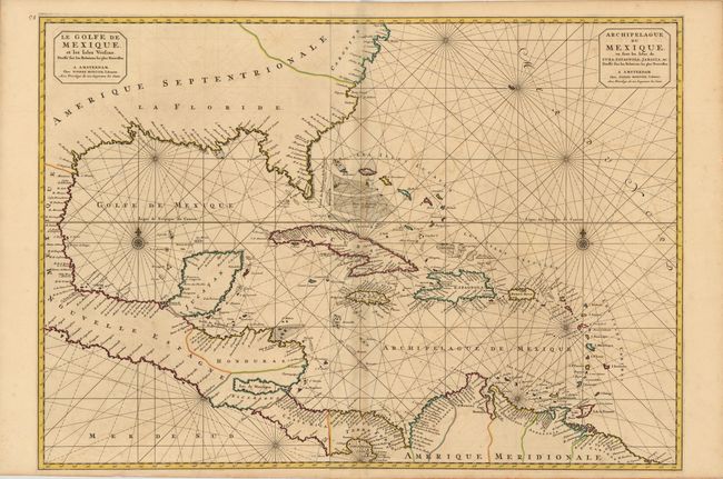
Auction 139, Lot 308
Subject: Gulf of Mexico and Caribbean
Mortier, Pierre
Le Golfe de Mexique, et les Isles Voisine… / Archipelague du Mexique, ou sont les Isles de Cuba, Espagnola, Jamaica, &c., 1700
Size: 33.5 x 23.5 inches (85.1 x 59.7 cm)
Estimate: $1,600 - $2,000
Unsold
Closed on 2/15/2012

Auction 139, Lot 325
Subject: Havana, Cuba
Habana, 1848
Size: 10.8 x 7.3 inches (27.4 x 18.5 cm)
Estimate: $550 - $700
Unsold
Closed on 2/15/2012
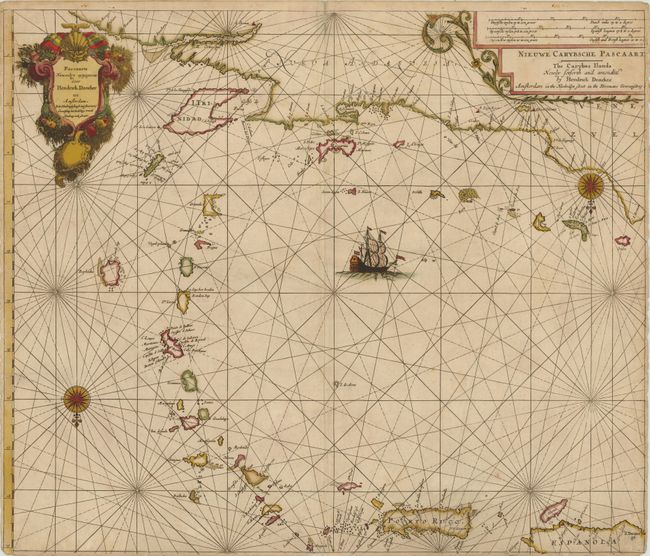
Auction 139, Lot 330
Subject: Puerto Rico and Lesser Antilles
Doncker, Henrick
Pascaarte Nieuwelyx Uytgegeven / Nieuwe Carybsche Pascaart The Carybes Ilands, 1658
Size: 24.5 x 20.8 inches (62.2 x 52.8 cm)
Estimate: $1,600 - $2,000
Unsold
Closed on 2/15/2012
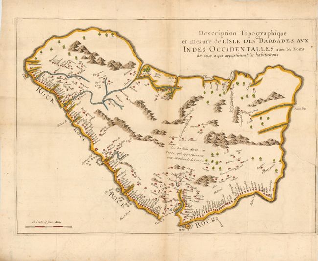
Auction 139, Lot 331
Subject: Barbados
Ligon, Richard
Description Topographique et Mesure de Lisle des Barbades aux Indes Occidentalles avec les Noms de ceux a qui Appartienent les Habitations, 1674
Size: 20.8 x 14.8 inches (52.8 x 37.6 cm)
Estimate: $1,500 - $2,000
Unsold
Closed on 2/15/2012
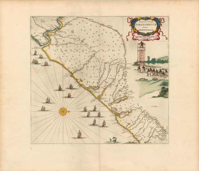
Auction 139, Lot 356
Subject: Brazil
Blaeu, Johannes
Praefecturae Paranambucae Pars Meridionalis, 1647
Size: 17.8 x 16.3 inches (45.2 x 41.4 cm)
Estimate: $1,400 - $1,800
Sold for: $1,300
Closed on 2/15/2012
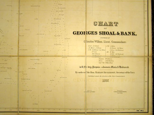
Auction 139, Lot 388
Subject: North Atlantic
Wilkes, Charles
Chart of Georges Shoal & Bank, Surveyed by Charles Wilkes, Lieut. Commandant…, 1837
Size: 44 x 39 inches (111.8 x 99.1 cm)
Estimate: $650 - $800
Rare Chart of George's Bank
Sold for: $400
Closed on 2/15/2012
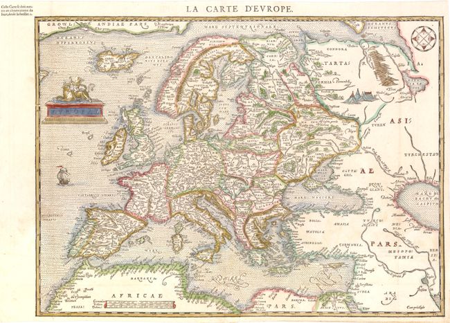
Auction 139, Lot 395
Subject: Europe
Belleforest, Francois
Europae, 1575
Size: 18.5 x 13.8 inches (47 x 35.1 cm)
Estimate: $2,000 - $2,400
Scarce Woodcut Version of Ortelius’ Map of Europe
Unsold
Closed on 2/15/2012
82 lots
Page 1 of 2