Showing Featured Lots(remove filter)
Showing results for:Auction 136
Catalog Archive
52 lots
Page 1 of 2
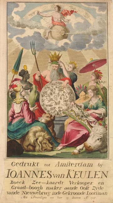
Auction 136, Lot 6
Subject: Title Pages
Keulen, Johannes van
Gedrukt tot Amsterdam by Ioannes van Keulen Boeck Zee-kaardt Verkooper en Graad-boogh maker aande Oost Zyde vande Nieuwebrug inde Gekroonde Lootsman, 1709
Size: 11.5 x 20.5 inches (29.2 x 52.1 cm)
Estimate: $300 - $375
Sold for: $200
Closed on 6/1/2011
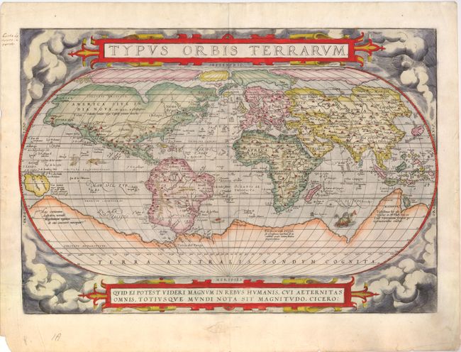
Auction 136, Lot 15
Subject: World
Ortelius, Abraham
Typus Orbis Terrarum, 1575
Size: 19.5 x 13.5 inches (49.5 x 34.3 cm)
Estimate: $8,000 - $10,000
Ortelius' famous world map
Sold for: $6,500
Closed on 6/1/2011
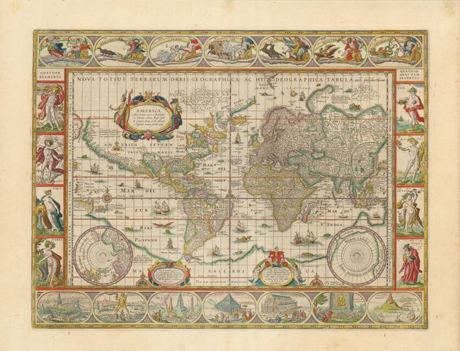
Auction 136, Lot 21
Subject: World
Blaeu, Willem
Nova Totius Terrarum Orbis Geographica ac Hydrographica Tabula, 1635
Size: 21.4 x 16 inches (54.4 x 40.6 cm)
Estimate: $20,000 - $24,000
Blaeu's Magnificent World Map
Sold for: $21,000
Closed on 6/1/2011

Auction 136, Lot 26
Subject: World
Stoopendaal, Bastiaan
Orbis Terrarum Tabula Recens Emendata et in Lucem Edita, 1686
Size: 18.2 x 14.2 inches (46.2 x 36.1 cm)
Estimate: $1,500 - $2,000
Unsold
Closed on 6/1/2011
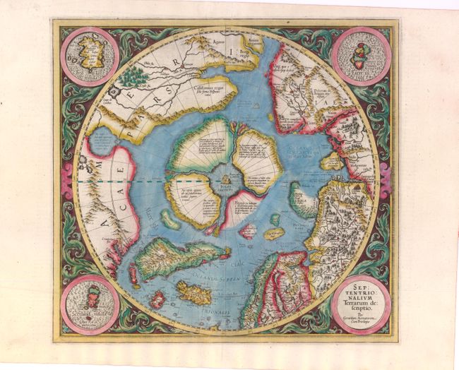
Auction 136, Lot 47
Subject: North Pole
Mercator, Gerard
Septentrionalium Terrarum Descriptio, 1606
Size: 15.5 x 14.8 inches (39.4 x 37.6 cm)
Estimate: $3,000 - $4,000
The First Printed Map Devoted to the Arctic
Unsold
Closed on 6/1/2011
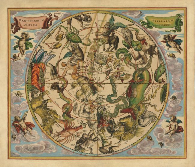
Auction 136, Lot 53
Subject: Celestial
Cellarius, Andreas
Haemisphaerium Stellatum Australe Antiquum, 1660
Size: 20.5 x 17.5 inches (52.1 x 44.5 cm)
Estimate: $4,000 - $5,000
One of the finest celestial charts from the golden age of Dutch cartography
Sold for: $3,000
Closed on 6/1/2011
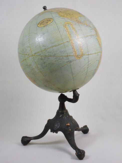
Auction 136, Lot 58
Subject: Globes
Rand McNally & Co.
12" Rand McNally Terrestrial Globe, 1920-24
Size: 14 x 22.5 inches (35.6 x 57.2 cm)
Estimate: $400 - $600
Sold for: $200
Closed on 6/1/2011
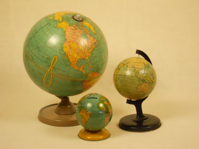
Auction 136, Lot 59
Subject: Globes
[Lot of 3 - Terrestrial Globes], 1933-50
Size: 12 x 12 inches (30.5 x 30.5 cm)
Estimate: $150 - $200
Sold for: $100
Closed on 6/1/2011
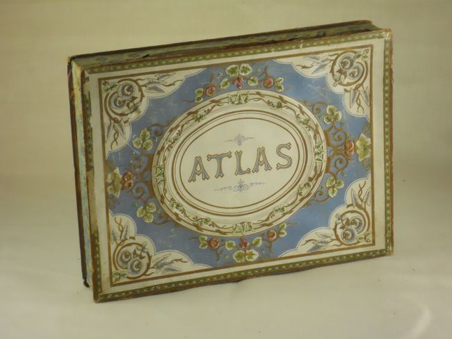
Auction 136, Lot 63
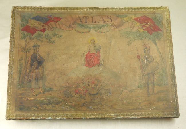
Subject: Puzzle Maps
Logerot, Auguste
[Puzzle Set] Atlas, 1850
Size: 12 x 9 inches (30.5 x 22.9 cm)
Estimate: $400 - $600
Complete 19th Century Puzzle Map Set in Original Box
Sold for: $400
Closed on 6/1/2011
Auction 136, Lot 64
Subject: Puzzle Maps
Delamarche
[Puzzle Maps] Atlas, 1884
Size: 19 x 13.4 inches (48.3 x 34 cm)
Estimate: $200 - $300
Sold for: $100
Closed on 6/1/2011
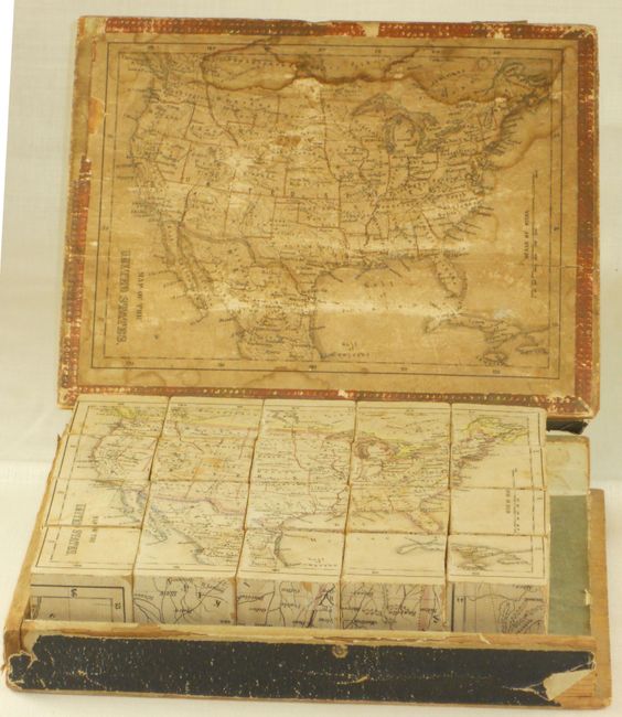
Auction 136, Lot 65
Subject: Puzzle Maps - United States
Anon.
[Set of 6 Puzzle Maps], 1865-66
Size: 7.8 x 10 inches (19.8 x 25.4 cm)
Estimate: $400 - $600
Rare cube-style puzzle map of the United States
Sold for: $425
Closed on 6/1/2011
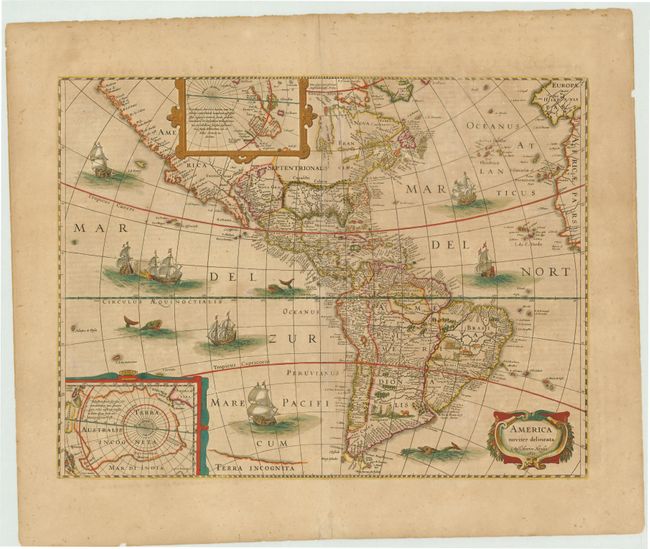
Auction 136, Lot 67
Subject: Western Hemisphere - America
Hondius, Henricus
America noviter delineata, 1631
Size: 19.8 x 14.8 inches (50.3 x 37.6 cm)
Estimate: $2,400 - $3,000
Unsold
Closed on 6/1/2011
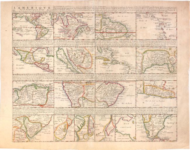
Auction 136, Lot 70
Subject: Western Hemisphere - America
Duval, Pierre
L'Amerique par P. Du Val Geographe du Roy, 1661
Size: 19.2 x 15.8 inches (48.8 x 40.1 cm)
Estimate: $5,000 - $6,000
A rare, very early map of the Island of California
Unsold
Closed on 6/1/2011
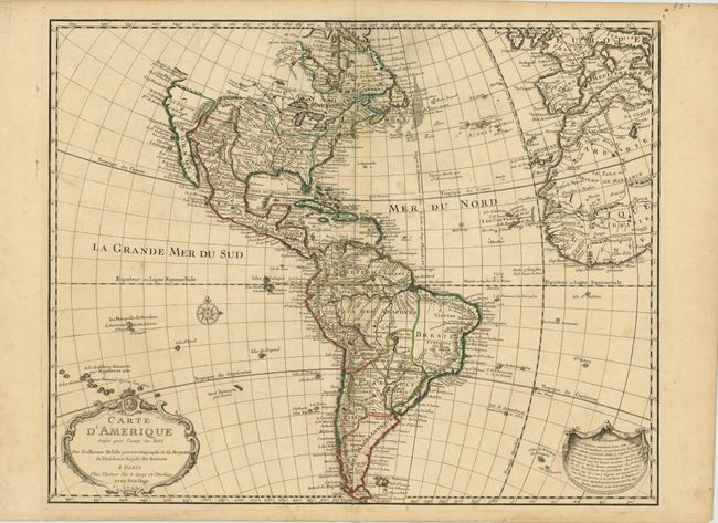
Auction 136, Lot 73
Subject: Western Hemisphere
Delisle, Guillaume
Carte d'Amerique Dressee pour l'Usage du Roy…, 1722
Size: 24.3 x 19.3 inches (61.7 x 49 cm)
Estimate: $1,200 - $1,500
Scarce First State of One of the Most Popular American Maps of the Eighteenth Century
Unsold
Closed on 6/1/2011
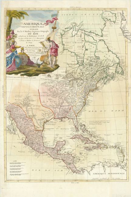
Auction 136, Lot 82
Subject: Western Hemisphere
Moithey, Maurille Antoine
[Lot of 2] Amerique Septentrionale Publiee par le Sr. Moithey ... [and] Amerique Meridionale…, 1788-89
Size: 20.5 x 29 inches (52.1 x 73.7 cm)
Estimate: $2,200 - $3,000
Unsold
Closed on 6/1/2011
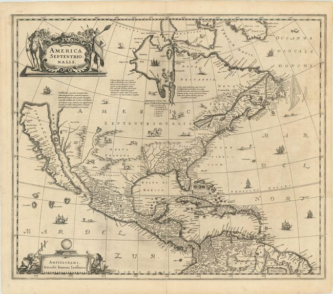
Auction 136, Lot 88
Subject: North America
Hondius/Jansson
America Septentrionalis, 1644
Size: 22 x 18 inches (55.9 x 45.7 cm)
Estimate: $3,000 - $4,000
Influential map showing the Island of California
Sold for: $3,250
Closed on 6/1/2011
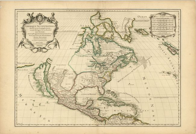
Auction 136, Lot 90
Subject: North America
Sanson/Jaillot
Amerique Septentrionale Divisee en ses Principales Parties…, 1698
Size: 25.5 x 18 inches (64.8 x 45.7 cm)
Estimate: $2,500 - $3,000
A superb map showing the Island of California
Unsold
Closed on 6/1/2011
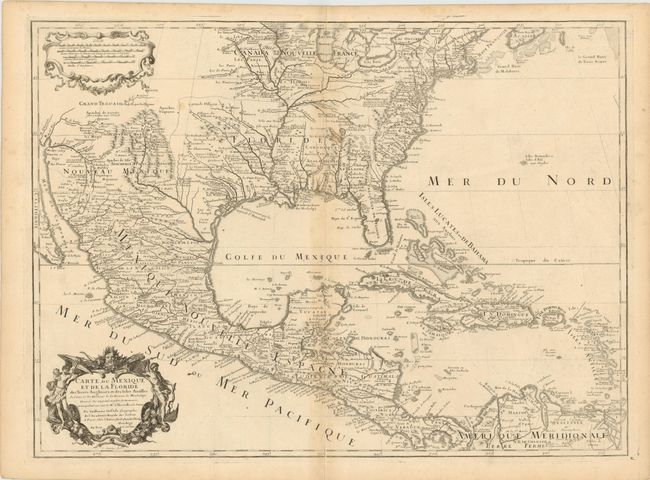
Auction 136, Lot 104
Subject: Colonial North America and Caribbean
Delisle, Guillaume
Carte du Mexique et de la Floride des Terres Angloises et des Isles Antilles du Cours et des Environs de la Riviere de Mississipi…, 1703
Size: 26 x 19 inches (66 x 48.3 cm)
Estimate: $1,700 - $2,000
A Landmark in American Cartography - The first printed map to accurately depict the mouth of the Mississippi River
Sold for: $1,300
Closed on 6/1/2011
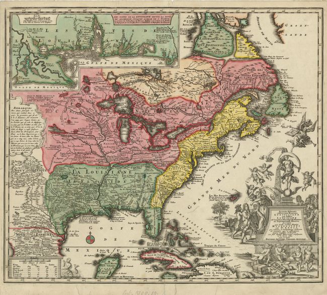
Auction 136, Lot 108
Subject: Colonial North America and Caribbean
Seutter, Matthias
Accurata delineatio celeberrimae Regionis Ludovicianae vel Gallice Louisiane ol Canadae et Floridae adpellatione in Septemtrionali America descripta quae hodie nomine fluminis Mississippi vel St. Louis…, 1740
Size: 22.5 x 19.5 inches (57.2 x 49.5 cm)
Estimate: $2,300 - $3,000
Sold for: $1,700
Closed on 6/1/2011
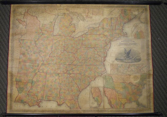
Auction 136, Lot 149
Subject: United States, Republic of Texas
Mitchell, Samuel Augustus
Mitchell's Reference & Distance Map of the United States, 1844
Size: 67 x 52.5 inches (170.2 x 133.4 cm)
Estimate: $8,000 - $10,000
Exceptional Wall Map Featuring the Independent Republic of Texas - 1844
Unsold
Closed on 6/1/2011
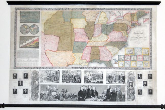
Auction 136, Lot 152
Subject: United States
Ensign, Thayer & Co.
Ensign's Travellers' Guide, and Map of the United States, Containing the Roads, Distances, Steam Boat and Canal Routes &c., 1848
Size: 39 x 26 inches (99.1 x 66 cm)
Estimate: $2,500 - $3,000
Flawless example of Ensign & Thayer's rare wall map
Sold for: $1,800
Closed on 6/1/2011
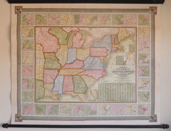
Auction 136, Lot 176
Subject: Eastern United States
Mitchell, Samuel Augustus
Mitchell's National Map of the American Republic or United States of North America, Together with Maps of the Vicinities of Thirty-Two of the Principal Cities and Towns in the Union, 1843
Size: 47 x 38 inches (119.4 x 96.5 cm)
Estimate: $2,500 - $3,000
Remarkable Example of Mitchell's Wall Map
Unsold
Closed on 6/1/2011
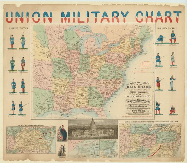
Auction 136, Lot 180
Subject: Eastern United States
Magnus & Co.
Union Military Chart, 1861-62
Size: 28 x 24 inches (71.1 x 61 cm)
Estimate: $800 - $1,200
Colorful Civil War Railroad Map
Sold for: $1,400
Closed on 6/1/2011
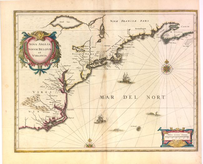
Auction 136, Lot 190
Subject: Colonial New England and Mid-Atlantic
Jansson, Jan
Nova Anglia Novum Belgium et Virginia, 1636
Size: 20 x 15.3 inches (50.8 x 38.9 cm)
Estimate: $1,900 - $2,200
Jansson's influential map of the East Coast
Unsold
Closed on 6/1/2011
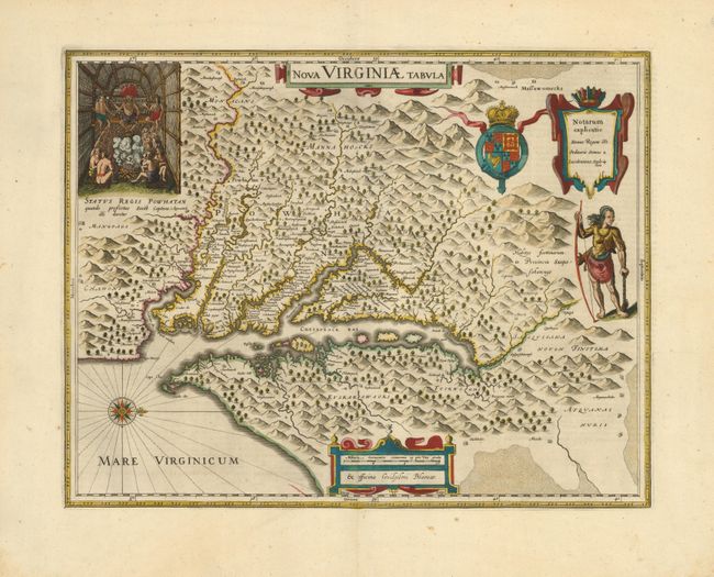
Auction 136, Lot 195
Subject: Colonial Mid-Atlantic
Hondius/Blaeu
Nova Virginiae Tabula, 1642
Size: 19 x 15 inches (48.3 x 38.1 cm)
Estimate: $2,750 - $3,500
One of the most important 17th century maps of the Chesapeake Bay
Sold for: $2,100
Closed on 6/1/2011
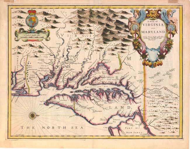
Auction 136, Lot 196
Subject: Colonial Mid-Atlantic
Speed/Lamb
A Map of Virginia and Maryland, 1676
Size: 19.5 x 15 inches (49.5 x 38.1 cm)
Estimate: $4,750 - $5,500
The first printed map to draw upon the legendary Herrman map of the Chesapeake Bay
Sold for: $3,500
Closed on 6/1/2011
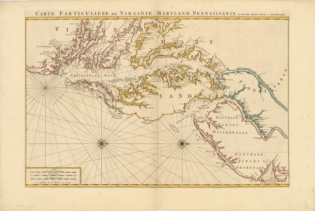
Auction 136, Lot 198
Subject: Colonial Mid-Atlantic
Jaillot/Mortier
Carte Particuliere de Virginie, Maryland, Pennsilvanie, la Nouvelle Iarsey Orient et Occidental, 1700
Size: 31.5 x 20.5 inches (80 x 52.1 cm)
Estimate: $7,000 - $9,000
One of the Most Beautiful Charts of Maryland and the Chesapeake Bay
Unsold
Closed on 6/1/2011
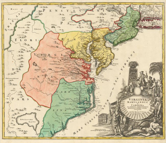
Auction 136, Lot 200
Subject: Colonial Mid-Atlantic
Homann, Johann Baptist
Virginia Marylandia et Carolina in America Septentrionali Britannorum industria excultae, 1730
Size: 22.8 x 19.2 inches (57.9 x 48.8 cm)
Estimate: $1,900 - $2,200
Sold for: $1,200
Closed on 6/1/2011
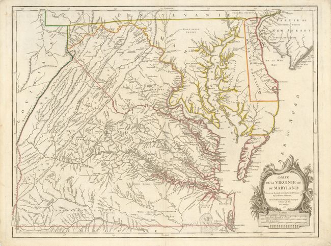
Auction 136, Lot 201
Subject: Colonial Mid-Atlantic
Robert de Vaugondy, Didier
Carte de la Virginie et du Maryland Dressee sur la Grande Carte Angloise de Mrs. Josue Fry et Pierre Jefferson…, 1755
Size: 25.5 x 19.2 inches (64.8 x 48.8 cm)
Estimate: $3,000 - $3,750
An Essential Map of Virginia and Maryland
Sold for: $2,300
Closed on 6/1/2011
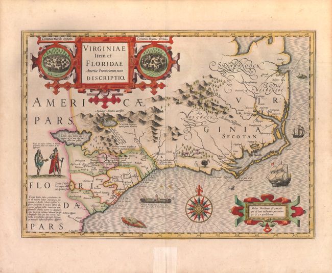
Auction 136, Lot 211
Subject: Colonial Southeast
Hondius, Jodocus
Virginiae Item et Floridae Americae Provinciarum, Nova Descriptio, 1619
Size: 19 x 13.5 inches (48.3 x 34.3 cm)
Estimate: $2,750 - $3,500
A Seminal Map of the Southeast and early American cartography
Sold for: $2,000
Closed on 6/1/2011
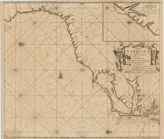
Auction 136, Lot 214
Subject: Colonial Southeast
Keulen, Johannes van
Pas Kaart Van de Kust van Carolina Tusschen C de Canaveral en C Henry…, 1687
Size: 22 x 20 inches (55.9 x 50.8 cm)
Estimate: $3,500 - $4,500
Scarce Dutch chart of the Carolinas
Sold for: $2,500
Closed on 6/1/2011
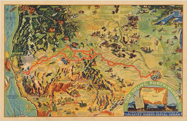
Auction 136, Lot 246
Subject: Western United States
The Young Forty-Niners, 1933
Size: 30 x 18.8 inches (76.2 x 47.8 cm)
Estimate: $180 - $240
Cartograph-style California Gold Rush map
Sold for: $375
Closed on 6/1/2011
Auction 136, Lot 298
Subject: Louisiana
Third Report from the Select Committee on Emigration from the United Kingdom, 1827
Size: 8.5 x 13.2 inches (21.6 x 33.5 cm)
Estimate: $1,600 - $2,400
Rare Parliamentary Report Regarding Emigration from Britain to the United States
Unsold
Closed on 6/1/2011
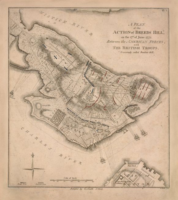
Auction 136, Lot 304
Subject: Boston, Massachusetts
Smith, Charles
A Plan of the Action at Breeds Hill*, on the 17th of June 1775. Between the American Forces, and the British Troops. *Erroneously Called Bunkers Hill, 1796
Size: 8.3 x 9.2 inches (21.1 x 23.4 cm)
Estimate: $3,000 - $4,000
The first detailed plan of the Battle of Bunker Hill published in the United States
Unsold
Closed on 6/1/2011
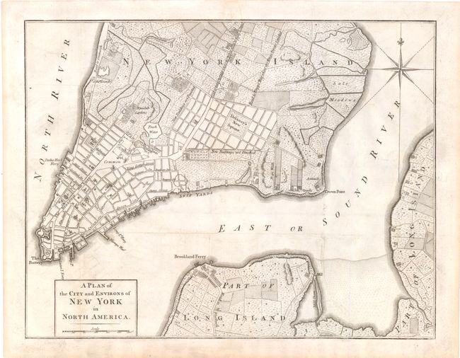
Auction 136, Lot 322
Subject: New York City, New York
Anon.
A Plan of the City and Environs of New York in North America, 1776
Size: 14.5 x 11.3 inches (36.8 x 28.7 cm)
Estimate: $1,500 - $1,800
Sold for: $1,900
Closed on 6/1/2011
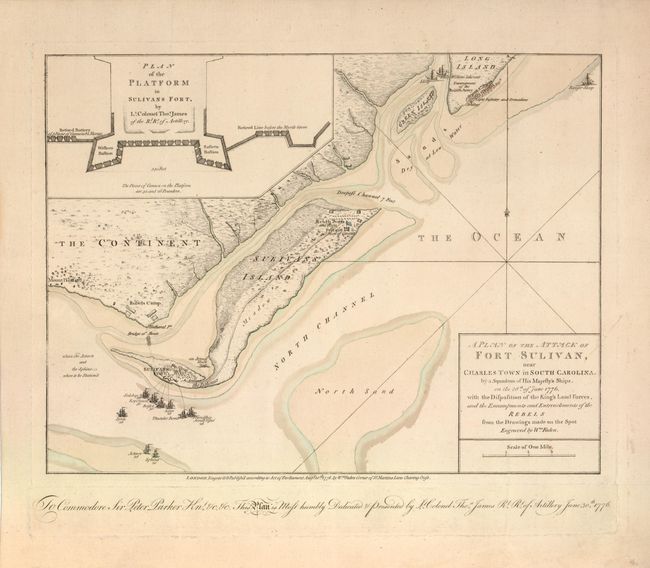
Auction 136, Lot 336
Subject: Charleston, South Carolina
Faden, William
A Plan of the Attack of Fort Sulivan, near Charles Town in South Carolina…, 1776
Size: 14.6 x 11 inches (37.1 x 27.9 cm)
Estimate: $10,000 - $12,000
Important Revolutionary War Map
Unsold
Closed on 6/1/2011
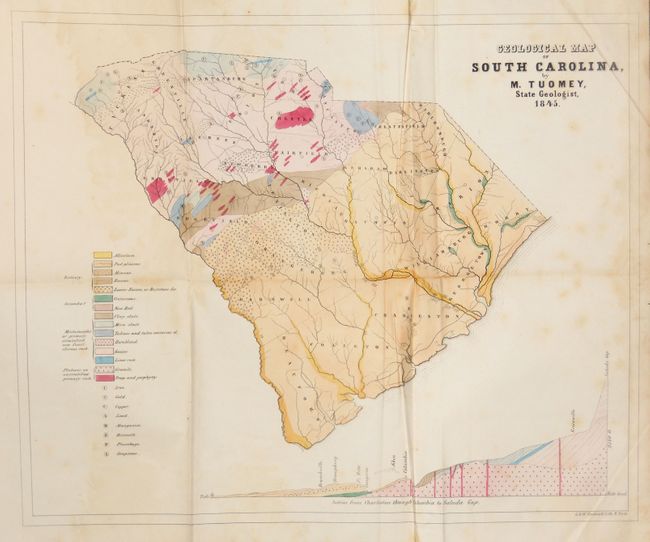
Auction 136, Lot 339
Subject: South Carolina
Tuomey, Michael
Geological Map of South Carolina, by M. Tuomey, State Geologist, 1845, 1848
Size: 9 x 10.5 inches (22.9 x 26.7 cm)
Estimate: $400 - $500
Early Geological Map of South Carolina
Unsold
Closed on 6/1/2011
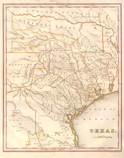
Auction 136, Lot 340
Subject: Republic of Texas
Bradford, Thomas Gamaliel
Texas, 1838
Size: 11.3 x 14.4 inches (28.7 x 36.6 cm)
Estimate: $2,500 - $3,000
Bradford's Republic of Texas
Sold for: $2,100
Closed on 6/1/2011
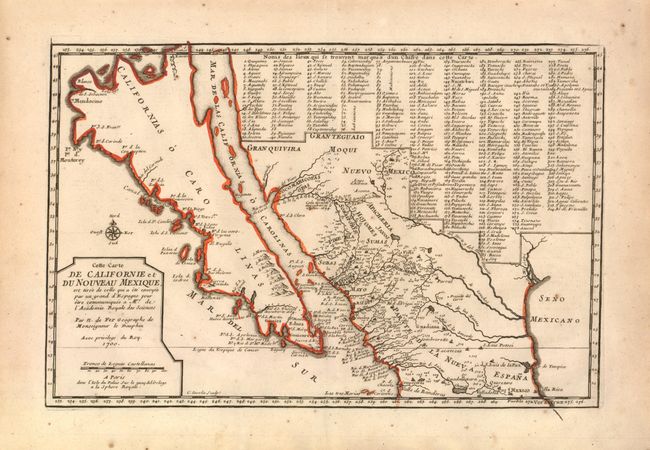
Auction 136, Lot 361
Subject: California, Southwest and Mexico
Fer, Nicolas de
Cette Carte de Californie et du Nouveau Mexique…, 1700
Size: 13.3 x 8.8 inches (33.8 x 22.4 cm)
Estimate: $1,400 - $1,900
Sold for: $1,100
Closed on 6/1/2011
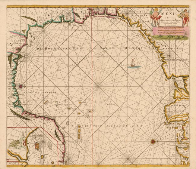
Auction 136, Lot 383
Subject: Gulf of Mexico
Keulen, Gerard van
Pas Kaart van de Golff van Mexico, 1724
Size: 22.8 x 20.3 inches (57.9 x 51.6 cm)
Estimate: $3,500 - $4,000
The first sea chart of the western portion of the Gulf of Mexico
Unsold
Closed on 6/1/2011
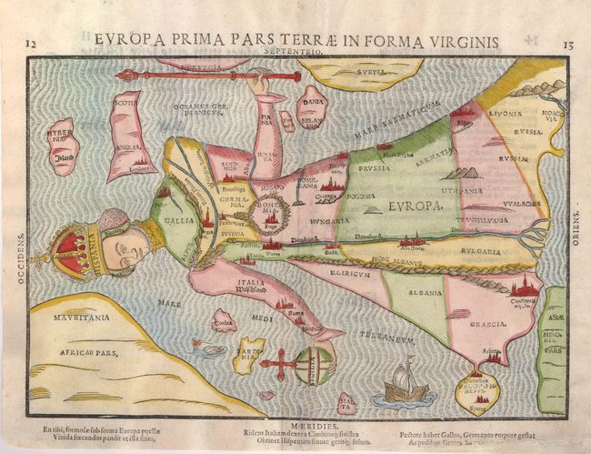
Auction 136, Lot 463
Subject: Europe
Bunting, Heinrich
Europa Prima Pars Terrae in Forma Virginis, 1582
Size: 14.5 x 11 inches (36.8 x 27.9 cm)
Estimate: $2,750 - $3,500
Europe depicted as the Queen of the World
Sold for: $2,000
Closed on 6/1/2011
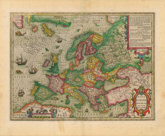
Auction 136, Lot 465
Subject: Europe
Hondius, Jodocus
Nova Europae Descriptio, 1623
Size: 19.5 x 14.6 inches (49.5 x 37.1 cm)
Estimate: $1,500 - $1,700
Sold for: $2,100
Closed on 6/1/2011
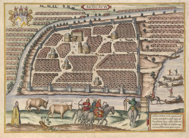
Auction 136, Lot 586
Subject: Moscow, Russia
Braun & Hogenberg
Moscauw, 1575
Size: 19.3 x 13.8 inches (49 x 35.1 cm)
Estimate: $2,400 - $3,000
Sold for: $1,900
Closed on 6/1/2011
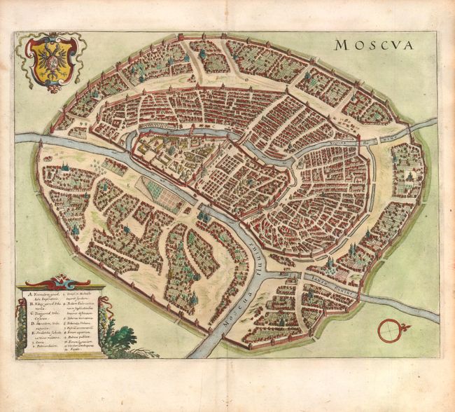
Auction 136, Lot 587
Subject: Moscow, Russia
Merian, Matthaus
Moscva, 1650
Size: 13.9 x 10.8 inches (35.3 x 27.4 cm)
Estimate: $1,100 - $1,400
Unsold
Closed on 6/1/2011
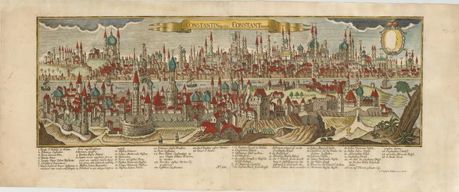
Auction 136, Lot 641
Subject: Istanbul, Turkey
Haffner, Johann Christoph
Constantinopolis. Constantinopel, 1740
Size: 26 x 10.8 inches (66 x 27.4 cm)
Estimate: $3,500 - $4,500
Unsold
Closed on 6/1/2011
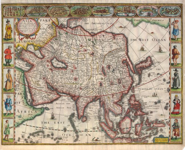
Auction 136, Lot 668
Subject: Asia
Speed, John
Asia with the Islands Adioyning Described, the Atire of the People, & Townes of Importance, All of them Newly Augmented, 1626
Size: 19.8 x 15.4 inches (50.3 x 39.1 cm)
Estimate: $4,000 - $5,000
Sold for: $3,000
Closed on 6/1/2011
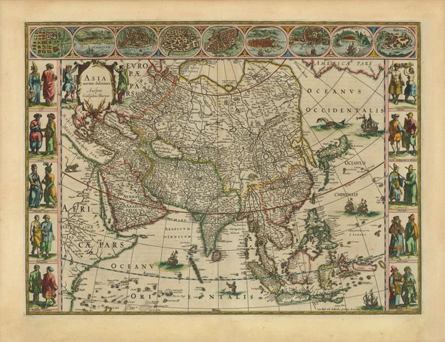
Auction 136, Lot 669
Subject: Asia
Blaeu, Willem
Asia Noviter Delineata, 1640
Size: 22 x 16.3 inches (55.9 x 41.4 cm)
Estimate: $5,000 - $6,000
Magnificent Carte-a-Figures Map of Asia
Sold for: $4,750
Closed on 6/1/2011
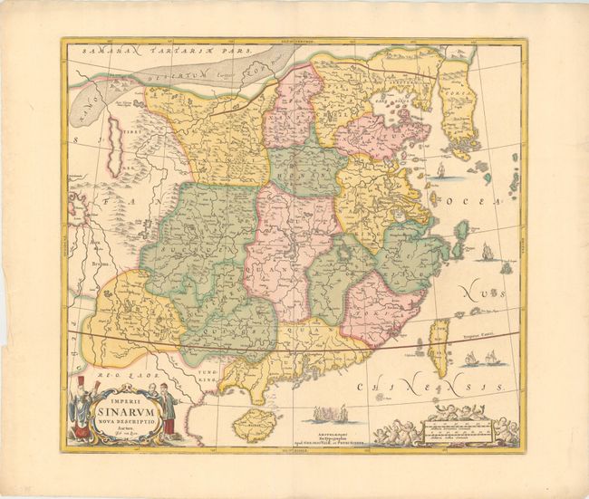
Auction 136, Lot 690
Subject: China & Korea
Jansson/Valck & Schenk
Imperii Sinarum Nova Descriptio Auctore Joh van Loon, 1700
Size: 20.8 x 18.5 inches (52.8 x 47 cm)
Estimate: $1,600 - $1,800
Unsold
Closed on 6/1/2011
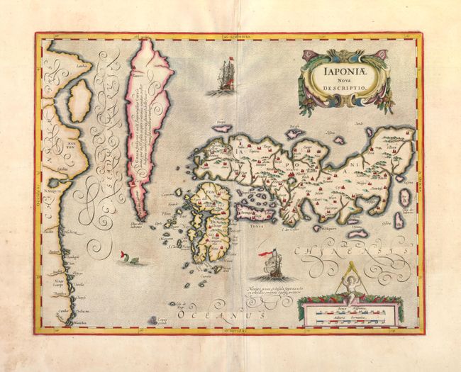
Auction 136, Lot 692
Subject: Japan and Korea
Jansson, Jan
Iaponiae Nova Descriptio, 1636
Size: 17.4 x 13.4 inches (44.2 x 34 cm)
Estimate: $1,800 - $2,100
Unsold
Closed on 6/1/2011
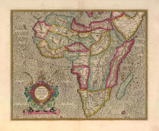
Auction 136, Lot 722
Subject: Africa
Mercator, Gerard (the younger)
Africa ex magna orbis terre descriptione Gerardi Mercatoris desumpta, 1607
Size: 18.5 x 14.8 inches (47 x 37.6 cm)
Estimate: $1,400 - $1,700
Sold for: $1,000
Closed on 6/1/2011
52 lots
Page 1 of 2