Showing Featured Lots(remove filter)
Filtered by Category:United States(Show All Categories)
Showing results for:Auction 97
Catalog Archive
27 lots
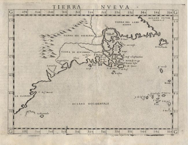
Auction 97, Lot 93
Subject: North America
Ruscelli, Girolamo
Tierra Nueva, 1574
Size: 9.6 x 7.1 inches (24.4 x 18 cm)
Estimate: $1,200 - $1,300
Sold for: $1,200
Closed on 12/5/2001
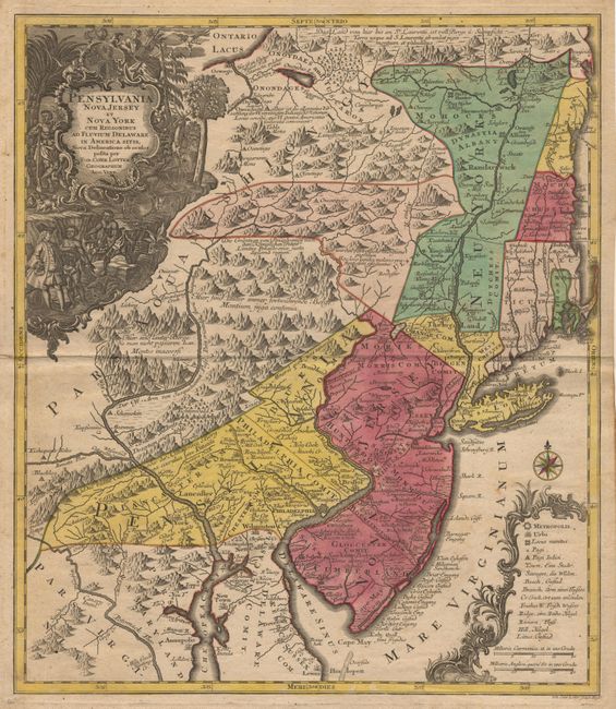
Auction 97, Lot 98
Subject: Colonial New England
Seutter/Lotter
Pensylvania Nova Jersey et Nova York cum Regionibus ad Fluvium Delaware in America sitis…, 1760
Size: 19.2 x 22.2 inches (48.8 x 56.4 cm)
Estimate: $2,500 - $2,750
Sold for: $1,800
Closed on 12/5/2001
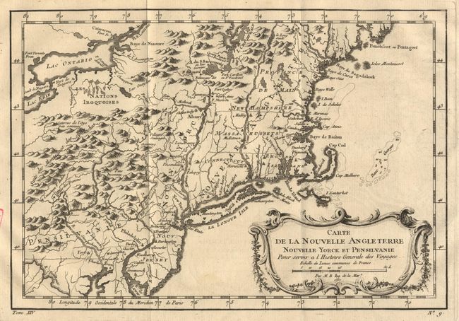
Auction 97, Lot 99
Subject: Colonial New England
Bellin, Jacques Nicolas
Carte de la Nouvelle Angleterre, Nouvelle Yorck et Pensilvanie, 1767
Size: 11.7 x 8.1 inches (29.7 x 20.6 cm)
Estimate: $375 - $425
Sold for: $375
Closed on 12/5/2001
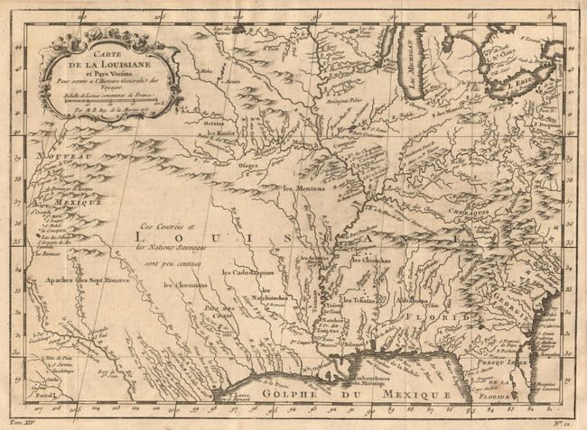
Auction 97, Lot 101
Subject: Colonial Central United States
Bellin, Jacques Nicolas
Carte de la Louisiane et Pays Voisins Pour servir a l'Histoire Generale des Voyages, 1757
Size: 12 x 8.8 inches (30.5 x 22.4 cm)
Estimate: $275 - $325
Sold for: $350
Closed on 12/5/2001
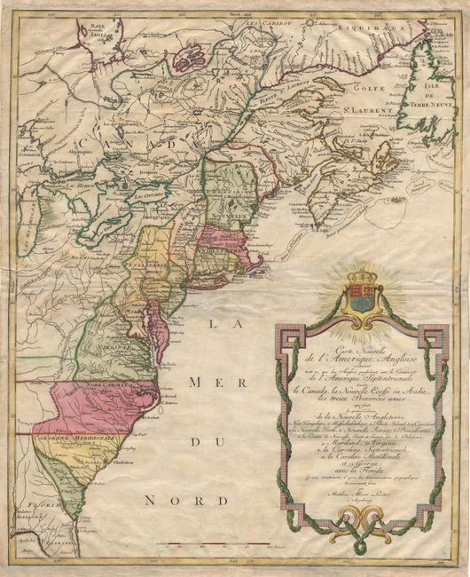
Auction 97, Lot 102
Subject: Colonial North America
Lotter, Mathias Albrecht
Carte Nouvelle de l'Amerique Angloise contenant tout ce que Anglois possedent sur le Continent de l'Amerique Septentrionale Savoir le Canada, la Nouvelle Ecosse ou Acadie, les treize Provinces unies.., 1776
Size: 19.2 x 23.7 inches (48.8 x 60.2 cm)
Estimate: $800 - $1,000
Sold for: $800
Closed on 12/5/2001
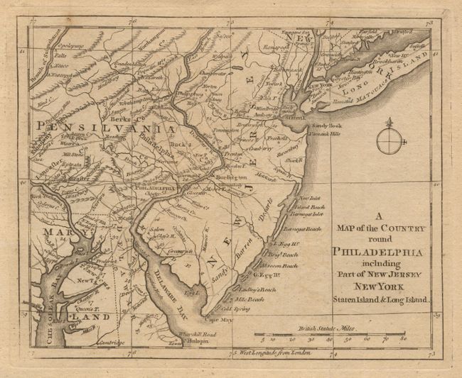
Auction 97, Lot 106
Subject: Colonial Mid-Atlantic
Anon.
A Map of the Country round Philadelphia including Part of New Jersey, New York, Staten Island & Long Island, 1776
Size: 8.8 x 7 inches (22.4 x 17.8 cm)
Estimate: $200 - $250
Sold for: $200
Closed on 12/5/2001
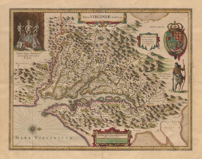
Auction 97, Lot 107
Subject: Colonial Southeast
Hondius, Henricus
Nova Virginiae Tabula, 1665
Size: 19.5 x 15 inches (49.5 x 38.1 cm)
Estimate: $2,300 - $2,500
Sold for: $2,300
Closed on 12/5/2001
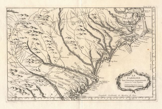
Auction 97, Lot 111
Subject: Colonial Southeast
Bellin, Jacques Nicolas
La Caroline dans l'Amerique Septentrionale Suivant les Cartes Angloises, 1764
Size: 14 x 8.8 inches (35.6 x 22.4 cm)
Estimate: $350 - $450
Sold for: $300
Closed on 12/5/2001
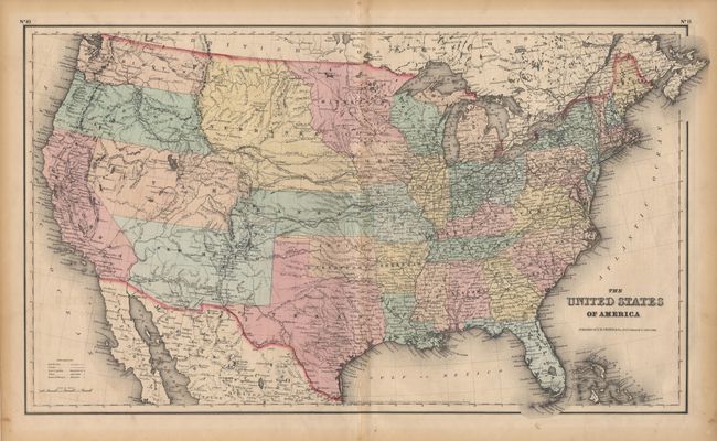
Auction 97, Lot 131
Subject: United States
Colton, Joseph Hutchins
The United States of America, 1855
Size: 25 x 14.6 inches (63.5 x 37.1 cm)
Estimate: $300 - $350
Sold for: $240
Closed on 12/5/2001
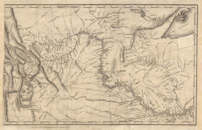
Auction 97, Lot 145
Subject: Central United States
Lewis & Clark
[A Map of Lewis & Clarks track across the western portion of North America…], 1814
Size: 18.7 x 11.7 inches (47.5 x 29.7 cm)
Estimate: $500 - $600
Sold for: $900
Closed on 12/5/2001
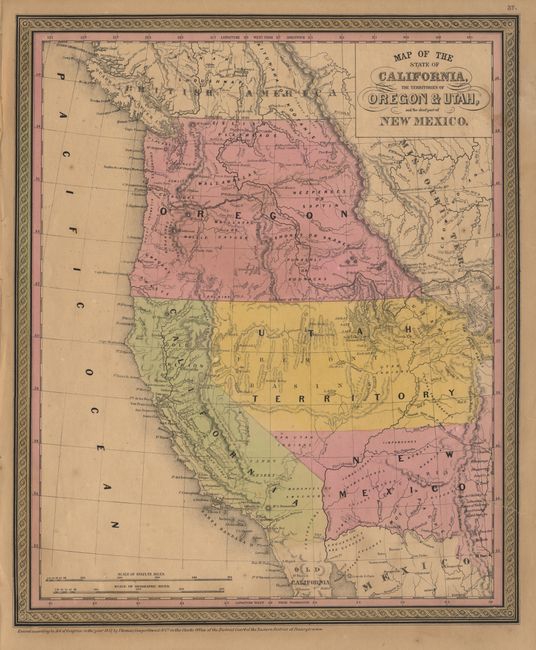
Auction 97, Lot 155
Subject: Western United States
Thomas, Cowperthwait & Co.
Map of the State of California, the Territories of Oregon & Utah, and the chief part of New Mexico, 1851
Size: 12.7 x 15.5 inches (32.3 x 39.4 cm)
Estimate: $450 - $550
Sold for: $500
Closed on 12/5/2001

Auction 97, Lot 162
Subject: Western United States
Warner & Beers
County Map of Colorado, Utah, New Mexico and Arizona, 1875
Size: 14.2 x 16.2 inches (36.1 x 41.1 cm)
Estimate: $80 - $100
Sold for: $80
Closed on 12/5/2001

Auction 97, Lot 174
Subject: California
U.S. Coast Survey
San Diego Entrance and Approaches [on sheet with] General Sketch of San Diego Bay and Los Coronados, 1850
Size: 13 x 11.7 inches (33 x 29.7 cm)
Estimate: $100 - $140
Sold for: $160
Closed on 12/5/2001

Auction 97, Lot 176
Subject: California
U.S. Coast Survey
Reconnaissance of Catalina Harbor and the Anchorage on the N. E. Side of the Island, 1852
Size: 10.5 x 14.8 inches (26.7 x 37.6 cm)
Estimate: $80 - $100
Sold for: $60
Closed on 12/5/2001

Auction 97, Lot 177
Subject: California
U.S. Coast Survey
Monterey Harbor California, 1852
Size: 11.6 x 13 inches (29.5 x 33 cm)
Estimate: $110 - $150
Sold for: $80
Closed on 12/5/2001

Auction 97, Lot 183
Subject: California
U.S. War Department
Bay of San Diego, 1891
Size: 13.5 x 17.2 inches (34.3 x 43.7 cm)
Estimate: $80 - $100
Sold for: $85
Closed on 12/5/2001

Auction 97, Lot 190
Subject: Colorado
Rand McNally & Co.
Rand, McNally & Co's Colorado, 1895
Size: 26 x 19 inches (66 x 48.3 cm)
Estimate: $100 - $130
Unsold
Closed on 12/5/2001

Auction 97, Lot 203
Subject: Louisiana
Tirion, Isaac
Grondvlakte van Nieuw Orleans, de Hoofdstad van Louisiana [on sheet with] De Uitloop van de Rivier Missisippi [and] De oostelyke Ingang van de Missisippi, met een Plan van het Fort, 't Welk het Kanaal Beheerscht, 1763
Size: 17.5 x 13 inches (44.5 x 33 cm)
Estimate: $800 - $850
Sold for: $700
Closed on 12/5/2001

Auction 97, Lot 204
Subject: Maine
Buchon, Jean Alexandre
Carte Geographique, Statistique et Historique du Maine, 1825
Size: 23.5 x 18.5 inches (59.7 x 47 cm)
Estimate: $180 - $220
Sold for: $210
Closed on 12/5/2001

Auction 97, Lot 208
Subject: Montana
U.S. Government
Map Showing original Boundary of the Crow Indian Reservation -Montana- and proposed cession to the United States, 1889
Size: 11.7 x 12.4 inches (29.7 x 31.5 cm)
Estimate: $90 - $120
Sold for: $160
Closed on 12/5/2001

Auction 97, Lot 219
Subject: Pennsylvania
Scull & Heap
A Map of Philadelphia and Parts Adjacent, 1777
Size: 11.5 x 13.1 inches (29.2 x 33.3 cm)
Estimate: $600 - $700
Sold for: $400
Closed on 12/5/2001
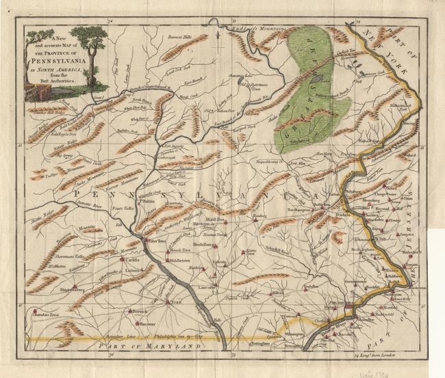
Auction 97, Lot 220
Subject: Pennsylvania
Anon.
A New and Accurate Map of the Province of Pennsylvania in North America, from the Best Authorities, 1780
Size: 12.6 x 10.7 inches (32 x 27.2 cm)
Estimate: $400 - $450
Sold for: $300
Closed on 12/5/2001

Auction 97, Lot 504
Subject: Arizona
Mollhausen, H. B.
Chimney Peak, 1861
Size: 8.9 x 6.5 inches (22.6 x 16.5 cm)
Estimate: $110 - $130
Sold for: $70
Closed on 12/5/2001

Auction 97, Lot 506
Subject: California
Vancouver, George (Capt)
The Presidio of Monterrey [together with] A Remarkable Mountain near the River of Monterrey, 1798
Size: 9.1 x 6.1 inches (23.1 x 15.5 cm)
Estimate: $180 - $220
Sold for: $130
Closed on 12/5/2001

Auction 97, Lot 509
Subject: Montana
U.S. Railroad Surveys
[Set of 4 lithographs], 1856-61
Size: 9 x 5.8 inches (22.9 x 14.7 cm)
Estimate: $120 - $150
Sold for: $80
Closed on 12/5/2001

Auction 97, Lot 511
Subject: Virginia
Middleton, Charles T.
Sir Walter Raleigh ordering the Standard of Queen Elizabeth to be erected on the Coast of Virginia, 1779
Size: 6.4 x 10.7 inches (16.3 x 27.2 cm)
Estimate: $75 - $100
Unsold
Closed on 12/5/2001

Auction 97, Lot 632
Subject: Colonial Southeast
Hondius, Henricus
Nova Virginiae Tabula, 1665
Size: 19.5 x 15 inches (49.5 x 38.1 cm)
Estimate: $2,300 - $2,500
Unsold
Closed on 12/5/2001
27 lots