Showing Featured Lots(remove filter)
Filtered by Category:United States(Show All Categories)
Showing results for:Auction 155
Catalog Archive
16 lots
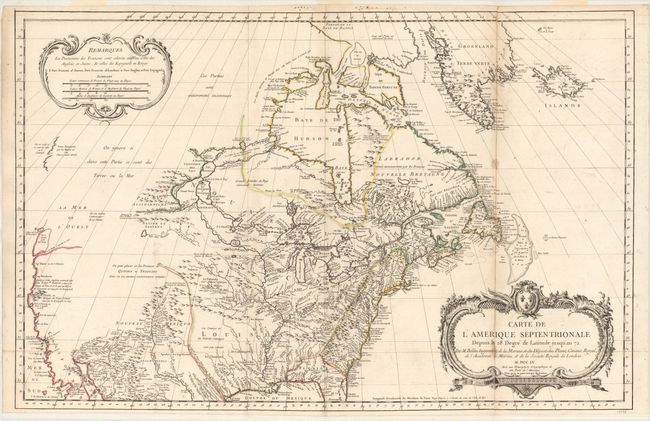
Auction 155, Lot 109
Subject: Colonial United States & Canada
Bellin, Jacques Nicolas
Carte de l'Amerique Septentrionale Depuis le 28 Degre de Latitude Jusqu'au 72, 1755
Size: 34 x 22 inches (86.4 x 55.9 cm)
Estimate: $1,500 - $1,800
NO RESERVE - Bellin's Important, Large Format Map of North America
Unsold
Closed on 11/18/2015
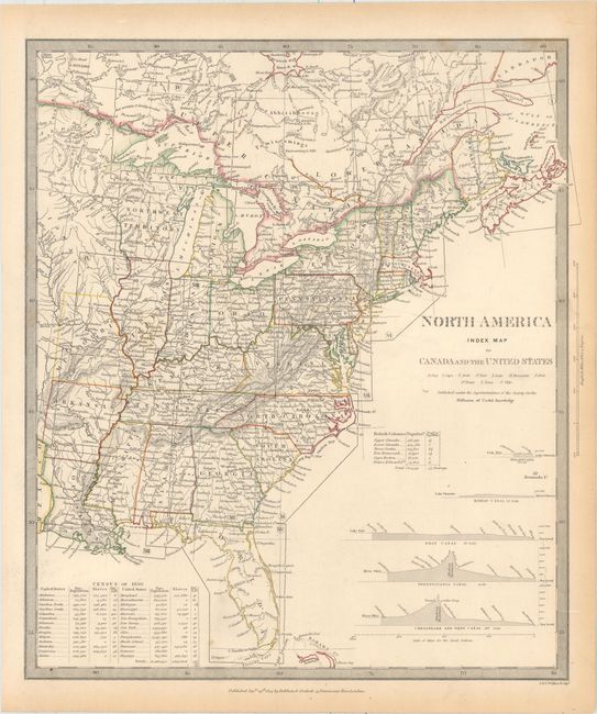
Auction 155, Lot 113
Subject: Canada & United States
SDUK Society for the Diffusion of Useful Knowledge
[Lot of 15 - North America], 1832-34
Size: See Description
Estimate: $1,300 - $1,600
Matching Set of North America SDUK Maps
Sold for: $650
Closed on 11/18/2015
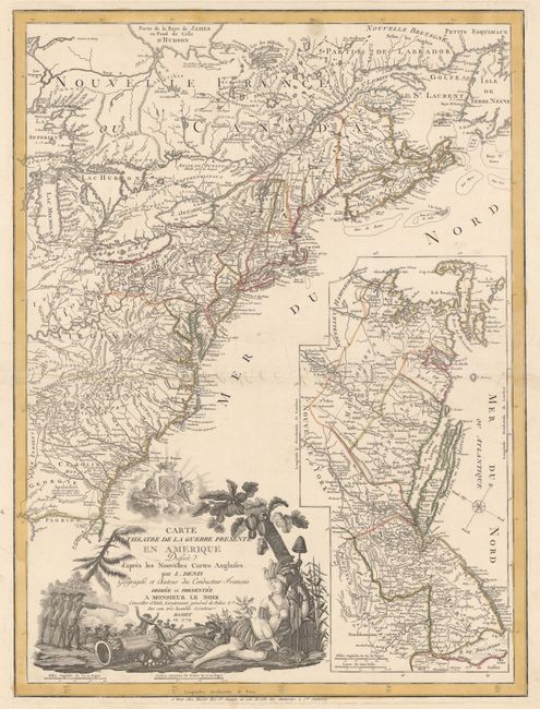
Auction 155, Lot 117
Subject: Colonial Eastern United States & Canada
Denis, Louis
Carte du Theatre de la Guerre Presente en Amerique Dressee d'Apres les Nouvelles Cartes Anglaises..., 1779
Size: 19.8 x 26.3 inches (50.3 x 66.8 cm)
Estimate: $5,500 - $6,500
Scarce American Revolutionary War Map
Unsold
Closed on 11/18/2015
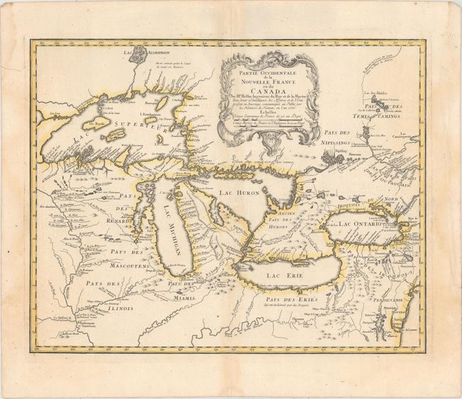
Auction 155, Lot 127
Subject: Colonial Great Lakes
Bellin/Homann Heirs
Partie Occidentale de la Nouvelle France ou du Canada, 1755
Size: 21.3 x 16.8 inches (54.1 x 42.7 cm)
Estimate: $1,400 - $1,700
Influential Map of the Great Lakes
Sold for: $1,500
Closed on 11/18/2015
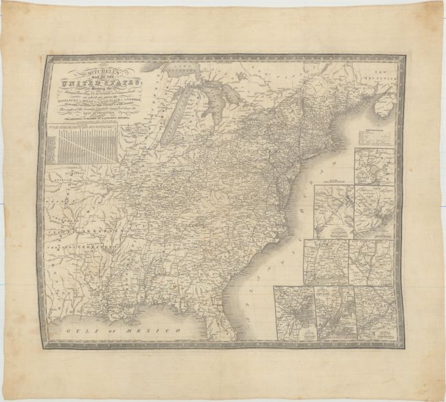
Auction 155, Lot 142
Subject: Eastern United States
Mitchell, Samuel Augustus
[Fabric Map] Mitchell's Map of the United States; Showing the Principal Travelling, Turnpike and Common Roads; on Which Are Given the Distances in Miles from One Place to Another..., 1836
Size: 23.6 x 19.1 inches (59.9 x 48.5 cm)
Estimate: $1,000 - $1,500
The Only Mitchell Map to be Printed on Silk
Sold for: $500
Closed on 11/18/2015
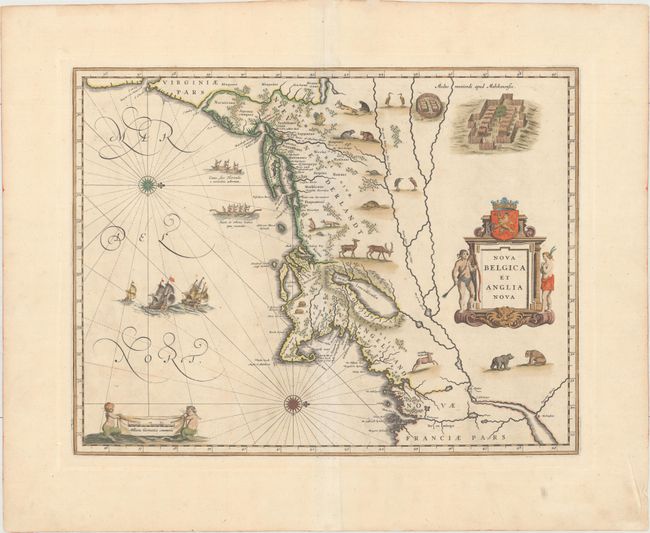
Auction 155, Lot 151
Subject: Colonial New England & Mid-Atlantic
Blaeu, Willem
Nova Belgica et Anglia Nova, 1635
Size: 19.6 x 15.2 inches (49.8 x 38.6 cm)
Estimate: $3,250 - $4,000
Important Map of Colonial New England and the Mid-Atlantic - Rare Example with Blank Verso
Sold for: $2,500
Closed on 11/18/2015
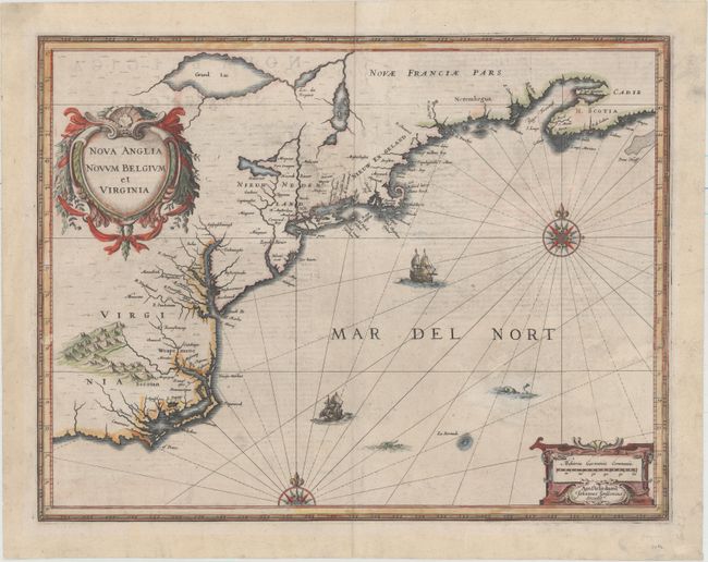
Auction 155, Lot 152
Subject: Colonial New England & Mid-Atlantic
Jansson, Jan
Nova Anglia Novum Belgium et Virginia, 1637
Size: 19.8 x 15.3 inches (50.3 x 38.9 cm)
Estimate: $1,600 - $1,900
Jansson's Influential Map of the East Coast
Sold for: $1,100
Closed on 11/18/2015
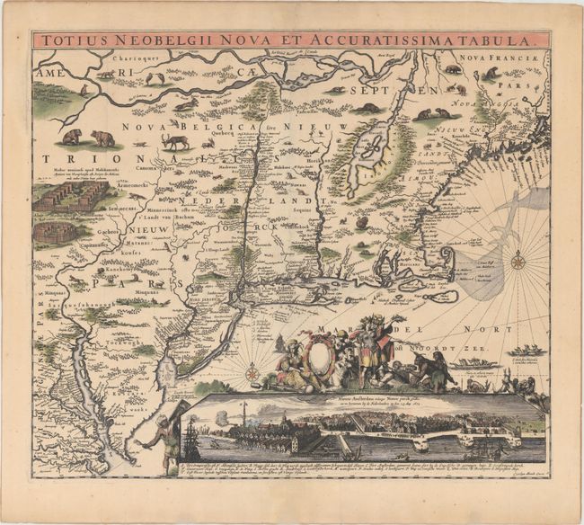
Auction 155, Lot 154
Subject: Colonial New England & Mid-Atlantic
Allard, Carel
Totius Neobelgii Nova et Accuratissima Tabula, 1680
Size: 21.3 x 18.3 inches (54.1 x 46.5 cm)
Estimate: $10,000 - $12,000
Rare Map of New England with Famous "Restitutio" View of New York City
Sold for: $7,500
Closed on 11/18/2015
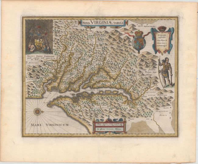
Auction 155, Lot 166
Subject: Colonial Mid-Atlantic United States
Hondius/Blaeu
Nova Virginiae Tabula, 1643
Size: 18.9 x 14.8 inches (48 x 37.6 cm)
Estimate: $2,750 - $3,500
One of the Most Important 17th Century Maps of the Chesapeake Bay
Unsold
Closed on 11/18/2015
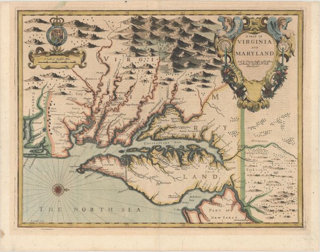
Auction 155, Lot 168
Subject: Colonial Mid-Atlantic United States
Speed/Lamb
A Map of Virginia and Maryland, 1676
Size: 19.4 x 14.8 inches (49.3 x 37.6 cm)
Estimate: $5,000 - $6,000
The First Printed Map to Draw Upon the Legendary Herrman Map of the Chesapeake Bay
Sold for: $4,250
Closed on 11/18/2015
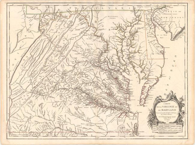
Auction 155, Lot 170
Subject: Colonial Mid-Atlantic United States
Robert de Vaugondy, Didier
Carte de la Virginie et du Maryland Dressee sur la Grande Carte Angloise de Mrs. Josue Fry et Pierre Jefferson..., 1755
Size: 25.4 x 19.1 inches (64.5 x 48.5 cm)
Estimate: $3,000 - $4,000
First State of Robert de Vaugondy's Essential Map of Virginia and Maryland
Unsold
Closed on 11/18/2015
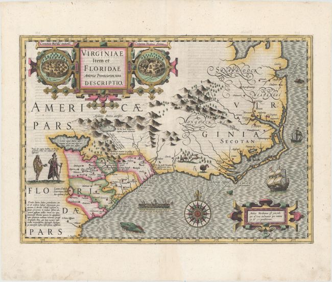
Auction 155, Lot 181
Subject: Colonial Southeast United States
Hondius, Jodocus
Virginiae Item et Floridae Americae Provinciarum, Nova Descriptio, 1607
Size: 19.1 x 13.5 inches (48.5 x 34.3 cm)
Estimate: $2,400 - $3,000
A Seminal Map of the Southeast and Early American Cartography
Sold for: $1,800
Closed on 11/18/2015
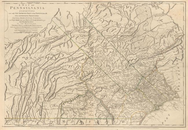
Auction 155, Lot 293
Subject: Pennsylvania
Sayer & Bennett
[On 2 Sheets] A Map of Pennsylvania Exhibiting Not Only the Improved Parts of that Province, but Also Its Extensive Frontiers…, 1775
Size: 19.7 x 26.8 inches (50 x 68.1 cm)
Estimate: $1,200 - $1,400
English Revision of William Scull’s Map of Pennsylvania
Sold for: $600
Closed on 11/18/2015
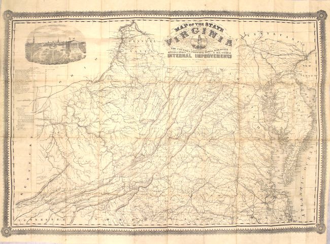
Auction 155, Lot 309
Subject: Virginia
West & Johnston
Map of the State of Virginia Containing the Counties, Principal Towns, Railroads, Rivers, Canals & all Other Internal Improvements, 1862
Size: 37 x 25.5 inches (94 x 64.8 cm)
Estimate: $9,500 - $12,000
Rare Civil War Map Based on Bucholtz Map of Virginia
Sold for: $6,500
Closed on 11/18/2015
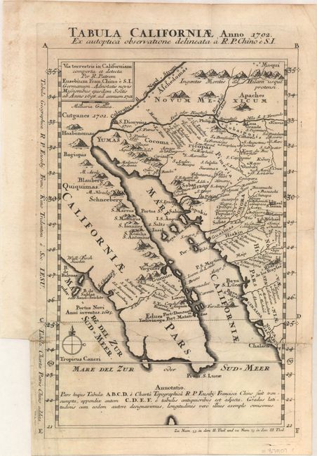
Auction 155, Lot 323
Subject: Southwestern United States & Mexico
Kino, Eusebio Francisco, SJ
Tabula Californiae, Anno 1702. Ex Autoptica Observatione Delineata a R.P. Chino e S.I., 1702
Size: 8.7 x 13.4 inches (22.1 x 34 cm)
Estimate: $1,600 - $2,000
NO RESERVE - Kino's Scarce Second Map of Lower California
Unsold
Closed on 11/18/2015
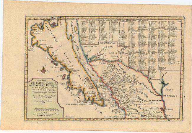
Auction 155, Lot 324
Subject: Southwestern United States & Mexico, California
Fer, Nicolas de
Cette Carte de Californie et du Nouveau Mexique, est Tiree de Celle qui a ete Envoyee par un Grand d'Espagne..., 1705
Size: 13.4 x 8.9 inches (34 x 22.6 cm)
Estimate: $1,200 - $1,500
De Fer's Important Map of the Island of California
Sold for: $900
Closed on 11/18/2015
16 lots