Showing Featured Lots(remove filter)
Filtered by Category:United States(Show All Categories)
Showing results for:Auction 152
Catalog Archive
14 lots
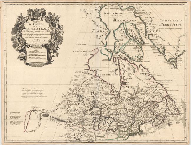
Auction 152, Lot 123
Subject: Colonial Northeastern United States & Canada, Great Lakes
Delisle, Guillaume
Carte du Canada ou de la Nouvelle France et des Decouvertes qui y ont ete faites..., 1703
Size: 25.7 x 19.7 inches (65.3 x 50 cm)
Estimate: $2,400 - $3,000
Delisle's Seminal Map of Canada and the Great Lakes
Sold for: $2,100
Closed on 2/18/2015
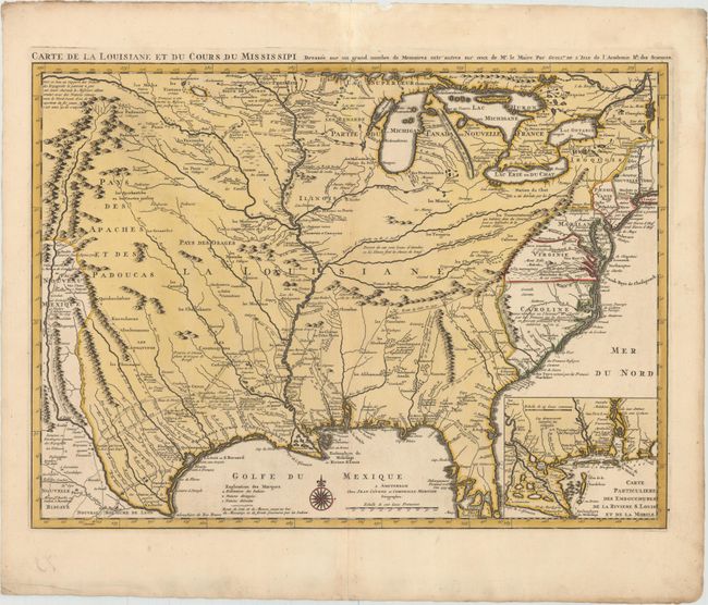
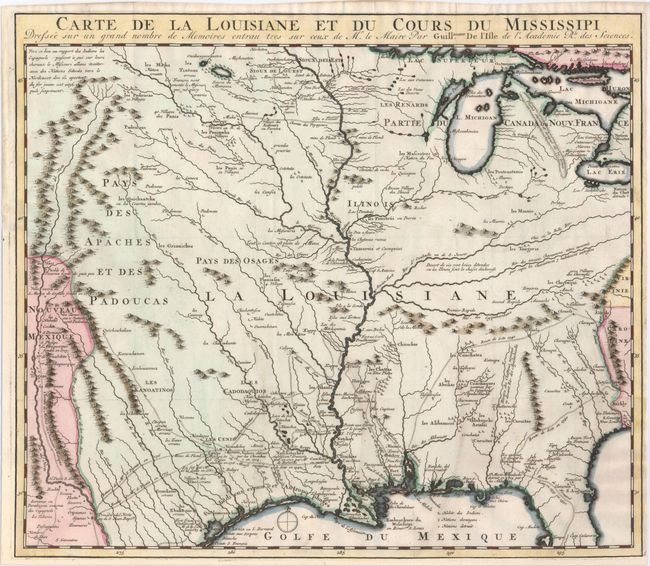
Auction 152, Lot 138
Subject: Colonial Eastern United States, Louisiana Territory
Delisle/Covens & Mortier
Carte de la Louisiane et du Cours du Mississipi Dressee sur un Grand Nombre de Memoires Entr'autres sur ceux de Mr. le Maire, 1730
Size: 23.6 x 17.3 inches (59.9 x 43.9 cm)
Estimate: $2,750 - $3,500
Delisle's Influential Map of the Louisiana Territory
Sold for: $1,800
Closed on 2/18/2015
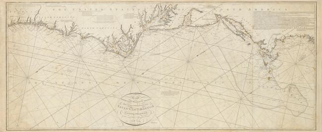
Auction 152, Lot 146
Subject: Eastern United States
Norie, John William
To the Independent Mariners of America, This Chart of their Coast from Savannah to Boston is most Respectfully Dedicated…, 1852
Size: 61 x 25.3 inches (154.9 x 64.3 cm)
Estimate: $2,000 - $2,300
Rare Blue-Back Chart of the East Coast
Sold for: $1,500
Closed on 2/18/2015
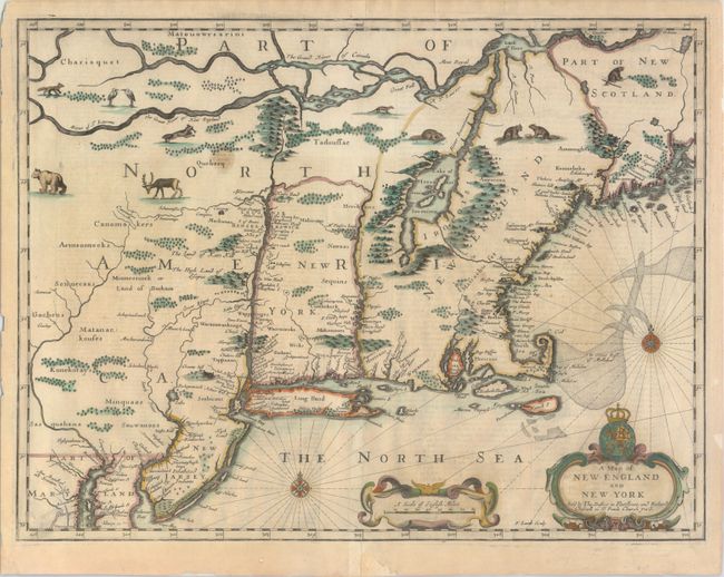
Auction 152, Lot 149
Subject: Colonial New England & New York
Speed/Lamb
A Map of New England and New York, 1676
Size: 19.7 x 15 inches (50 x 38.1 cm)
Estimate: $5,000 - $6,000
"Speed" Map of New England
Sold for: $3,500
Closed on 2/18/2015
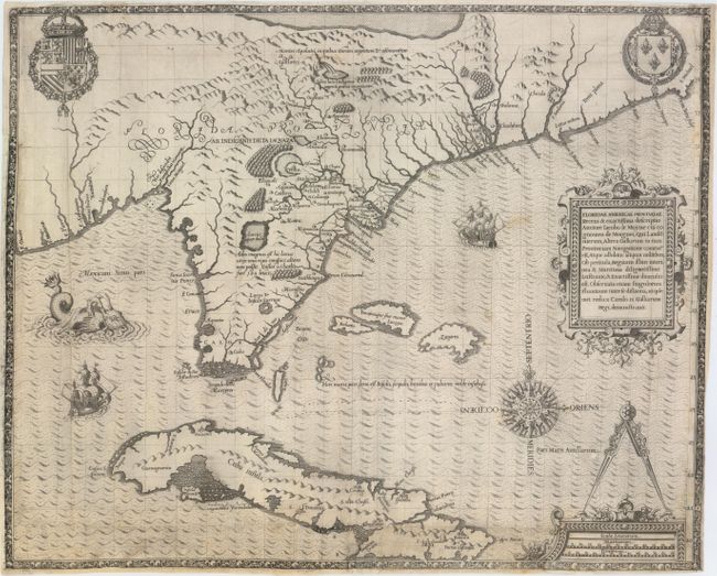
Auction 152, Lot 160
Subject: Colonial Southeast, Florida and Cuba
Bry, Theodore de
Floridae Americae Provinciae Recens & Exactissima Descriptio Auctore Iacobo le Moyne..., 1591
Size: 17.9 x 14.5 inches (45.5 x 36.8 cm)
Estimate: $11,000 - $15,000
De Bry's Influential Map of Colonial North America
Unsold
Closed on 2/18/2015
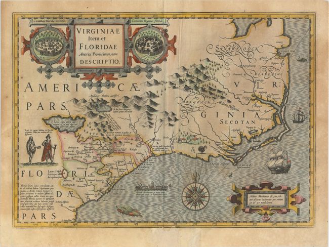
Auction 152, Lot 161
Subject: Colonial Southeast United States
Hondius, Jodocus
Virginiae Item et Floridae Americae Provinciarum, Nova Descriptio, 1623
Size: 19.2 x 13.6 inches (48.8 x 34.5 cm)
Estimate: $2,300 - $2,750
A Seminal Map of the Southeast and Early American Cartography
Sold for: $1,500
Closed on 2/18/2015
Auction 152, Lot 173
Subject: Colonial Central & Southern United States
Delisle, Guillaume
Carte de la Louisiane et du Cours du Mississipi Dressee sur un Grand Nombre de Memoires..., 1727
Size: 16.2 x 14 inches (41.1 x 35.6 cm)
Estimate: $2,000 - $2,300
Reduced-Size Edition of Delisle's Influential Map of the Louisiana Territory
Sold for: $1,000
Closed on 2/18/2015
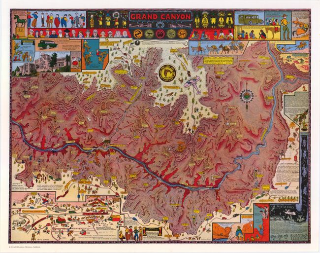
Auction 152, Lot 189
Subject: Grand Canyon, Arizona
Mora, Joseph Jacinto
Grand Canyon, 1959
Size: 18.1 x 14.1 inches (46 x 35.8 cm)
Estimate: $200 - $250
Reduced Version of Jo Mora's Splashy Map of the Grand Canyon
Sold for: $350
Closed on 2/18/2015
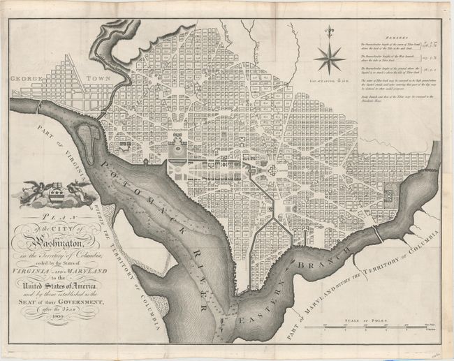
Auction 152, Lot 198
Subject: Washington, D.C.
Russell, John C.
Plan of the City of Washington, in the Territory of Columbia, Ceded by the States of Virginia and Maryland to the United States of America, and by Them Established as the Seat of Their Government, After the Year 1800, 1795
Size: 21 x 15.8 inches (53.3 x 40.1 cm)
Estimate: $3,000 - $3,750
Rare, Early Large Format Map of Washington D.C.
Sold for: $3,250
Closed on 2/18/2015
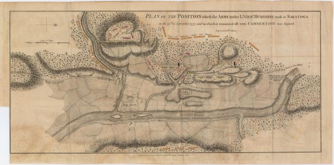
Auction 152, Lot 228
Subject: Colonial New York, Revolutionary War
Faden, William
Plan of the Position which the Army under Lt. Genl. Burgoine Took at Saratoga on the 10th of September 1777..., 1780
Size: 18.8 x 8.5 inches (47.8 x 21.6 cm)
Estimate: $1,500 - $1,800
Important Revolutionary War Map
Sold for: $750
Closed on 2/18/2015
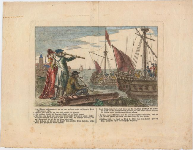
Auction 152, Lot 236
Subject: New York City, New York
Anon.
Die Sussigkeit des Friedens Wird Nur von Denen Verkannt, Welche die Plagen des Kriegs Nicht Erfahren Haben, 1790
Size: 10.1 x 6.7 inches (25.7 x 17 cm)
Estimate: $600 - $800
The Infamous British Prison Ships of the Revolutionary War
Sold for: $400
Closed on 2/18/2015
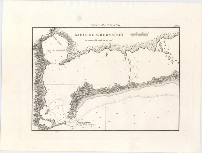
Auction 152, Lot 258
Subject: Matagorda Bay, Texas
Direccion de Hidrografia
Bahia de S. Bernardo, 1809
Size: 10.3 x 7.3 inches (26.2 x 18.5 cm)
Estimate: $800 - $1,000
First Engraved Map of Matagorda Bay
Sold for: $400
Closed on 2/18/2015
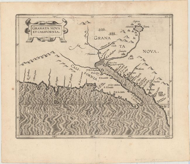
Auction 152, Lot 278
Subject: Southwestern United States & Mexico
Wytfliet, Cornelis
Granata Nova et California, 1597
Size: 11.4 x 9.1 inches (29 x 23.1 cm)
Estimate: $2,400 - $3,000
First Printed Map to Focus on California and the Southwest
Sold for: $2,000
Closed on 2/18/2015
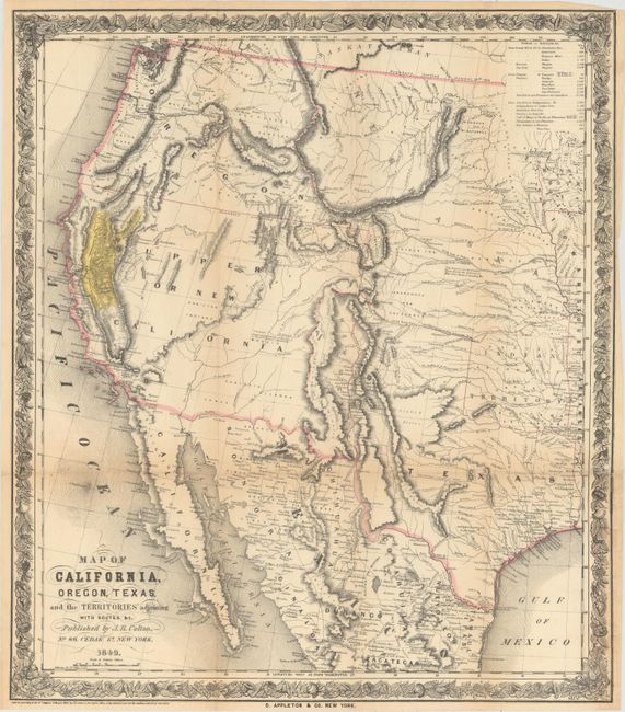
Auction 152, Lot 293
Subject: Western United States & Mexico
Colton, Joseph Hutchins
Map of California, Oregon, Texas, and the Territories Adjoining with Routes &c., 1849
Size: 18.1 x 20.8 inches (46 x 52.8 cm)
Estimate: $1,500 - $1,800
Colton's Rare Map Depicting the Gold Region of California
Sold for: $1,200
Closed on 2/18/2015
14 lots