Showing Featured Lots(remove filter)
Filtered by Category:United States(Show All Categories)
Showing results for:Auction 151
Catalog Archive
18 lots
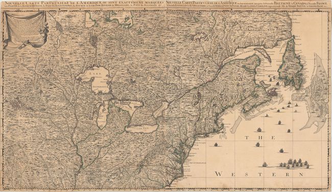
Auction 151, Lot 101
Subject: Colonial United States & Canada
Popple/Covens & Mortier
Nouvelle Carte Particuliere de l'Amerique, ou Sont Exactement Marquees, une Partie de la Baye d'Hudson… / … Ou sont Exactement Marquees la Nouvelle Bretagne, le Canada, ou Nouvelle France…, 1737
Size: 40.1 x 22.5 inches (101.9 x 57.2 cm)
Estimate: $3,500 - $4,500
The Two Northern Sheets of the Reduced Size Edition of Popple's Map
Sold for: $2,500
Closed on 11/19/2014
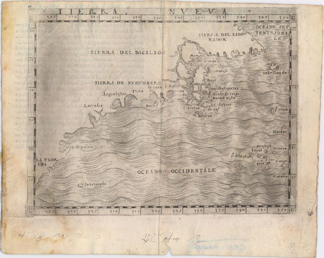
Auction 151, Lot 106
Subject: Eastern United States & Canada
Gastaldi, Giacomo
Tierra Nueva, 1548
Size: 6.7 x 5.1 inches (17 x 13 cm)
Estimate: $2,400 - $3,000
The First Published Map Devoted to the East Coast of North America
Sold for: $2,100
Closed on 11/19/2014
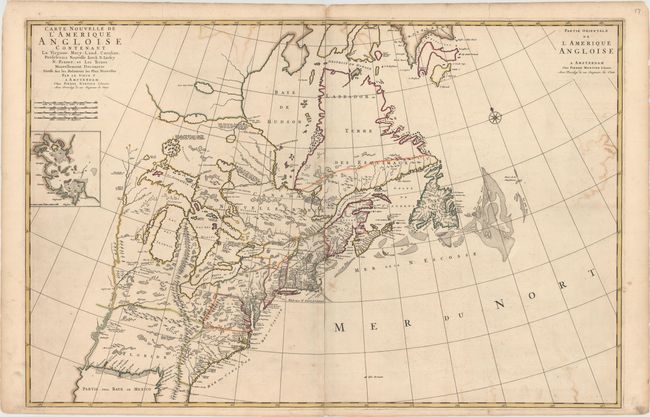
Auction 151, Lot 108
Subject: Colonial Eastern United States & Canada
Mortier, Pierre
Carte Nouvelle de l'Amerique Angloise Contenant la Virginie, Mary-Land, Caroline, Pensylvania Nouvelle Iorck, N: Iarsey N: France, et les Terres Nouvellement Decouerte..., 1700
Size: 35.8 x 23.4 inches (90.9 x 59.4 cm)
Estimate: $2,400 - $3,000
A Map Showing Fascinating Geographic Misconceptions
Unsold
Closed on 11/19/2014
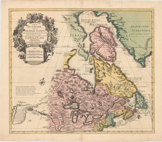
Auction 151, Lot 110
Subject: Colonial Eastern United States & Canada, Great Lakes
Delisle/Covens & Mortier
Carte du Canada ou de la Nouvelle France et des Decouvertes qui y ont ete Faites..., 1730
Size: 22.6 x 19.3 inches (57.4 x 49 cm)
Estimate: $1,400 - $1,700
One of the Most Influential Maps of Canada, the Great Lakes and Upper Midwest
Sold for: $1,400
Closed on 11/19/2014
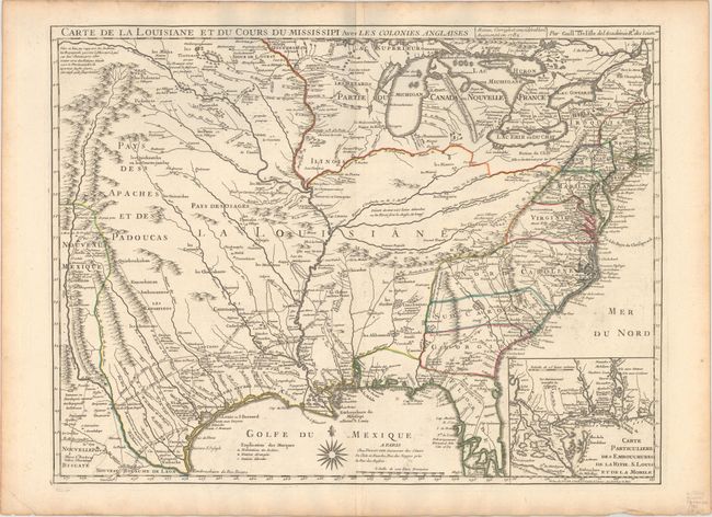
Auction 151, Lot 136
Subject: Colonial Eastern United States, Louisiana Territory
Delisle/Dezauche
Carte de la Louisiane et du Cours du Mississipi avec les Colonies Anglaises, 1782
Size: 25.6 x 19.3 inches (65 x 49 cm)
Estimate: $1,600 - $1,900
Delisle's Influential Map of the Louisiana Territory
Sold for: $1,300
Closed on 11/19/2014
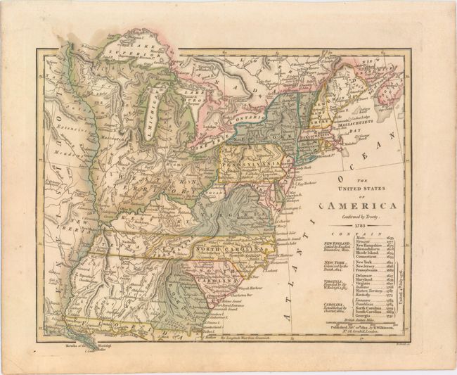
Auction 151, Lot 143
Subject: Eastern United States
Wilkinson, Robert
The United States of America Confirmed by Treaty. 1783, 1812
Size: 11.3 x 9.8 inches (28.7 x 24.9 cm)
Estimate: $900 - $1,100
Early Map of the United States Featuring Franklinia and the Indiana Land Company
Sold for: $700
Closed on 11/19/2014
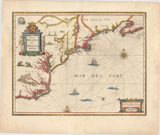
Auction 151, Lot 147
Subject: Colonial New England & Mid-Atlantic United States
Jansson, Jan
Nova Belgica et Anglia Nova, 1653
Size: 19.9 x 15.3 inches (50.5 x 38.9 cm)
Estimate: $1,600 - $1,900
Jansson's Influential Map of the East Coast
Sold for: $1,100
Closed on 11/19/2014
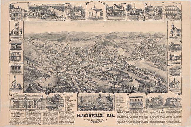
Auction 151, Lot 213
Subject: Placerville, California
Elliott, Wallace W.
Bird's Eye View Placerville, Cal., 1888
Size: 29 x 21 inches (73.7 x 53.3 cm)
Estimate: $2,400 - $3,000
View of California Gold Rush Town
Unsold
Closed on 11/19/2014
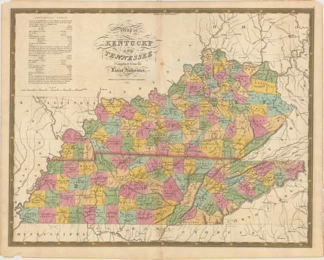
Auction 151, Lot 237
Subject: Kentucky & Tennessee
Mitchell, Samuel Augustus
Map of Kentucky and Tennessee Compiled from the Latest Authorities, 1831
Size: 21.5 x 17 inches (54.6 x 43.2 cm)
Estimate: $1,400 - $1,700
Rare Map Based on Finley's Map of 1826
Unsold
Closed on 11/19/2014
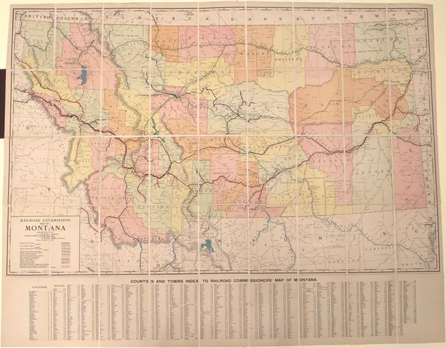
Auction 151, Lot 258
Subject: Montana, Railroads
Rand McNally & Co.
Railroad Commission Map of Montana, 1917
Size: 51.4 x 32.3 inches (130.6 x 82 cm)
Estimate: $900 - $1,100
Large, Attractive Railroad Map of Montana
Sold for: $450
Closed on 11/19/2014
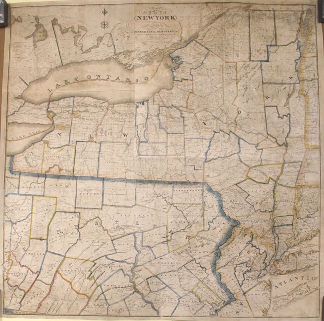
Auction 151, Lot 265
Subject: New York & Pennsylvania
Lay, Amos
Map of the State of New-York with Part of the States of Pennsylvania, New-Jersey &c., 1819
Size: 50.1 x 50 inches (127.3 x 127 cm)
Estimate: $2,750 - $3,500
Rare Wall Map of the State of New York
Sold for: $1,700
Closed on 11/19/2014
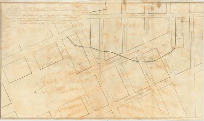
Auction 151, Lot 270
Subject: New York City, New York
[Lot of 2] A Map Shewing the Arrangement Agreed to Between the Corporation of Trinity Church, and the Proprietors of the Estate Late Ireland's, with Regard to Streets, &c. &c. [and] [Vellum Manuscript Indenture], 1796
Size: 21.5 x 12.4 inches (54.6 x 31.5 cm)
Estimate: $4,000 - $5,000
Early Manuscript Survey Map of Tribeca in Lower Manhattan
Unsold
Closed on 11/19/2014
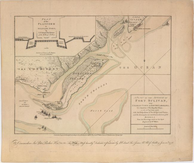
Auction 151, Lot 291
Subject: Charleston, South Carolina
Faden, William
A Plan of the Attack of Fort Sulivan, near Charles Town in South Carolina…, 1776
Size: 14.6 x 11 inches (37.1 x 27.9 cm)
Estimate: $5,500 - $7,000
Important Revolutionary War Map
Sold for: $3,750
Closed on 11/19/2014
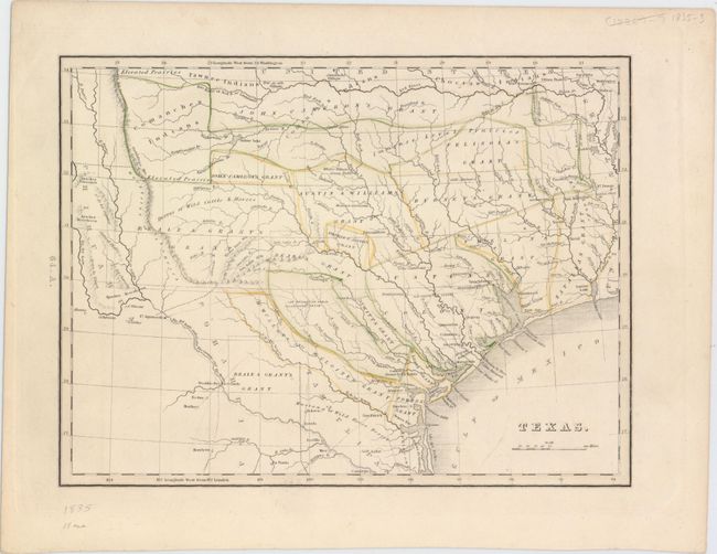
Auction 151, Lot 296
Subject: Texas
Bradford, Thomas Gamaliel
Texas, 1835
Size: 10.4 x 8.9 inches (26.4 x 22.6 cm)
Estimate: $2,500 - $3,250
First Separate Map of Texas in an American Atlas
Sold for: $2,100
Closed on 11/19/2014
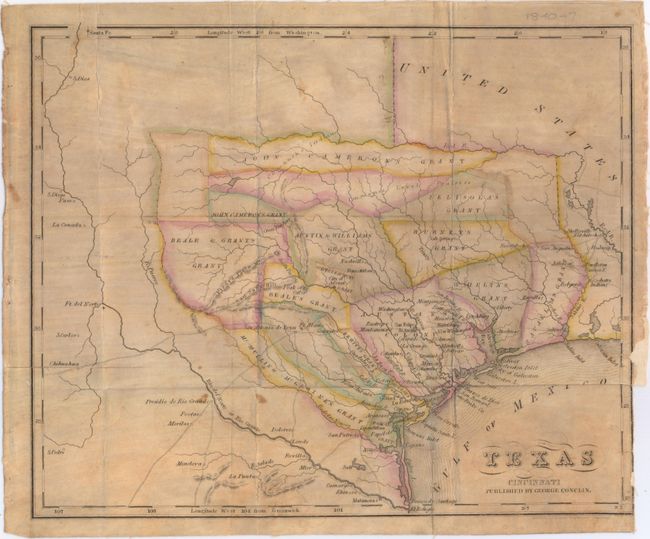
Auction 151, Lot 297
Subject: Texas
Texas, 1840
Size: 11.4 x 9.4 inches (29 x 23.9 cm)
Estimate: $4,000 - $5,000
Rare Republic Era Map
Sold for: $2,300
Closed on 11/19/2014
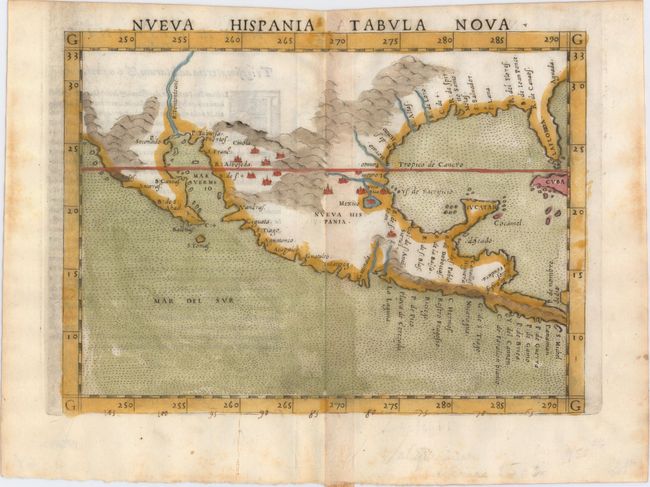
Auction 151, Lot 314
Subject: Southern United States & Mexico
Ruscelli, Girolamo
Nueva Hispania Tabula Nova, 1564
Size: 9.5 x 7.3 inches (24.1 x 18.5 cm)
Estimate: $1,300 - $1,600
A Foundation Map for the American Southwest
Sold for: $1,000
Closed on 11/19/2014
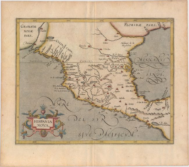
Auction 151, Lot 315
Subject: Southern United States & Mexico
Wytfliet, Cornelis
Hispania Nova, 1598
Size: 11.3 x 9 inches (28.7 x 22.9 cm)
Estimate: $900 - $1,100
Early Map of the American Southwest and Mexico
Sold for: $600
Closed on 11/19/2014
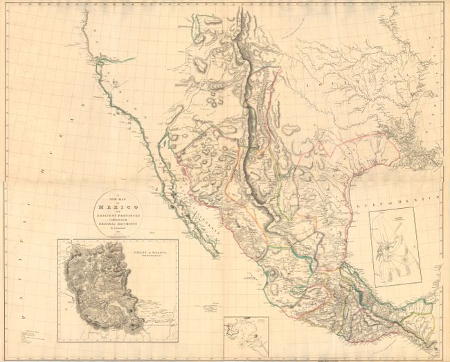
Auction 151, Lot 330
Subject: Western United States & Mexico
Arrowsmith, Aaron, Sr.
[On 4 Sheets] A New Map of Mexico and Adjacent Provinces Compiled from Original Documents, 1810
Size: 31.1 x 25.4 inches (79 x 64.5 cm)
Estimate: $15,000 - $17,000
Rare First State of Arrowsmith's Cornerstone Map of Texas and the Southwest
Sold for: $8,500
Closed on 11/19/2014
18 lots