Showing Featured Lots(remove filter)
Filtered by Category:United States(Show All Categories)
Showing results for:Auction 139
Catalog Archive
16 lots
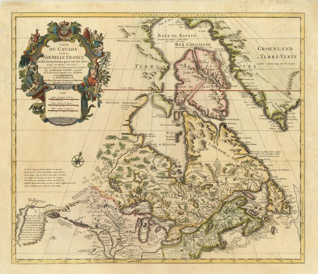
Auction 139, Lot 121
Subject: Colonial United States & Canada
Delisle/Covens & Mortier
Carte du Canada ou de la Nouvelle France et des Decouvertes qui y ont ete faites…, 1730
Size: 22.5 x 19.5 inches (57.2 x 49.5 cm)
Estimate: $1,300 - $1,600
One of the most influential maps of Canada, the Great Lakes and Upper Midwest
Sold for: $1,000
Closed on 2/15/2012
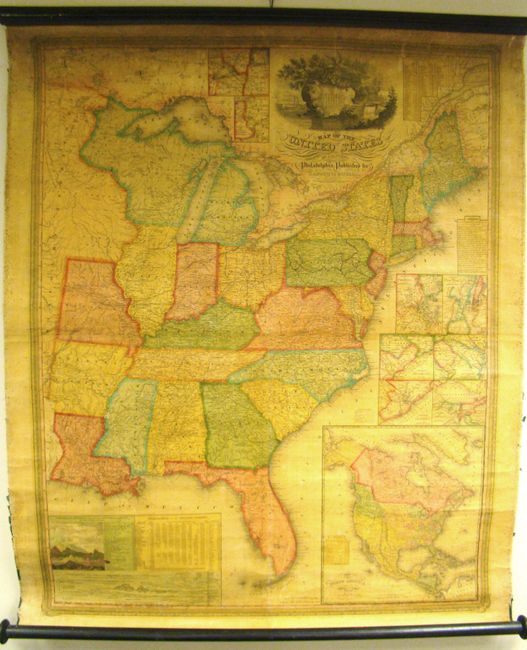
Auction 139, Lot 135
Subject: United States
Mitchell, Samuel Augustus
Map of the United States by J.H. Young, 1833
Size: 35 x 44 inches (88.9 x 111.8 cm)
Estimate: $1,000 - $1,500
Rare, Early Edition Mitchell Wall Map
Sold for: $1,200
Closed on 2/15/2012
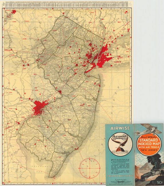
Auction 139, Lot 141
Subject: United States
Rand McNally & Co.
[Lot of 46] Rand McNally Standard Indexed Map with Air Trails, 1929-30
Size: 18.5 x 26 inches (47 x 66 cm)
Estimate: $1,600 - $2,000
Rare Rand McNally "Air Trails" Pocket Maps
Unsold
Closed on 2/15/2012
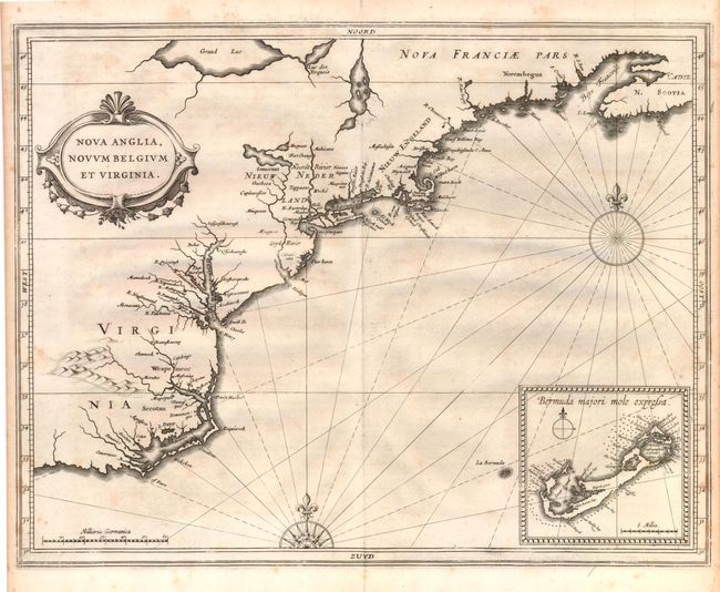
Auction 139, Lot 143
Subject: Colonial United States
Gerritsz/De Laet
Nova Anglia, Novum Belgium et Virginia, 1630
Size: 14 x 11 inches (35.6 x 27.9 cm)
Estimate: $5,000 - $7,000
A Map of Extreme Importance in the Cartographic Evolution of North America
Sold for: $3,750
Closed on 2/15/2012
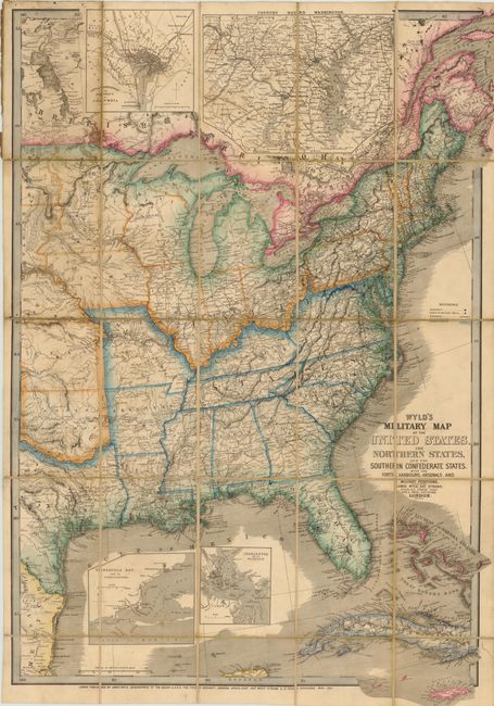
Auction 139, Lot 150
Subject: Eastern United States
Wyld, James
Wyld's Military Map of the United States, the Northern States, and the Southern Confederate States, with the Forts, Harbours, Arsenals, and Military Positions, 1861
Size: 23.3 x 35 inches (59.2 x 88.9 cm)
Estimate: $1,800 - $2,200
Important Civil War Map
Sold for: $1,300
Closed on 2/15/2012
Auction 139, Lot 152
Subject: Colonial New England and Mid-Atlantic
Jansson, Jan
Nova Anglia Novum Belgium et Virginia, 1636
Size: 20 x 15.3 inches (50.8 x 38.9 cm)
Estimate: $2,100 - $2,400
Jansson's Influential Map of the East Coast
Sold for: $2,000
Closed on 2/15/2012
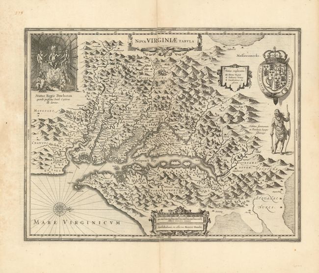
Auction 139, Lot 163
Subject: Colonial Mid-Atlantic
Hondius, Henricus
Nova Virginiae Tabula, 1630
Size: 19.5 x 15 inches (49.5 x 38.1 cm)
Estimate: $2,300 - $3,000
Unsold
Closed on 2/15/2012
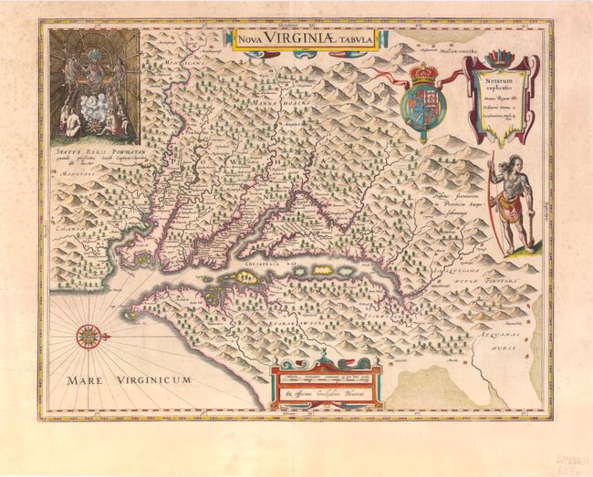
Auction 139, Lot 164
Subject: Colonial Mid-Atlantic
Hondius/Blaeu
Nova Virginiae Tabula, 1640
Size: 19 x 14.8 inches (48.3 x 37.6 cm)
Estimate: $3,000 - $4,000
Sold for: $1,900
Closed on 2/15/2012
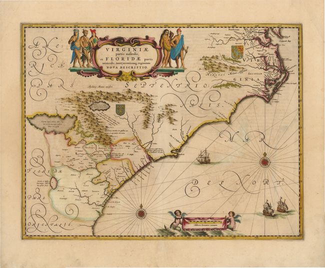
Auction 139, Lot 172
Subject: Colonial Southeast
Jansson, Jan
Virginiae Partis Australis, et Floridae Partis Orientalis, interjacentiumq Regionum Nova Descriptio, 1639
Size: 19.8 x 15.3 inches (50.3 x 38.9 cm)
Estimate: $1,600 - $1,800
Unsold
Closed on 2/15/2012
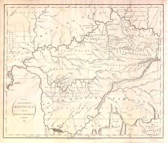
Auction 139, Lot 182
Subject: Kentucky and Tennessee
Russell, John C.
Map of the State of Kentucky; with the Adjoining Territories., 1794
Size: 17.8 x 15 inches (45.2 x 38.1 cm)
Estimate: $1,000 - $1,300
An Important Map of the Trans-Appalachian Frontier
Sold for: $950
Closed on 2/15/2012
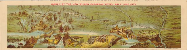
Auction 139, Lot 193
Subject: Central & Western United States - Utah
Route of the Mormon Pioneers from Nauvoo to Great Salt Lake, 1889
Size: 28.8 x 8.5 inches (73.2 x 21.6 cm)
Estimate: $500 - $650
Sold for: $300
Closed on 2/15/2012
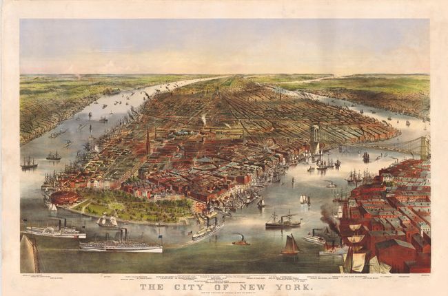
Auction 139, Lot 254
Subject: New York City, New York
Currier & Ives
The City of New York, 1870
Size: 32.8 x 22 inches (83.3 x 55.9 cm)
Estimate: $6,000 - $8,000
Fabulous View of the Brooklyn Bridge Prior to its Completion
Sold for: $11,000
Closed on 2/15/2012
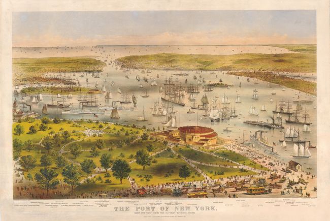
Auction 139, Lot 255
Subject: New York City, New York
Currier & Ives
The Port of New York, Bird's Eye View from the Battery Looking South, 1872
Size: 33 x 22 inches (83.8 x 55.9 cm)
Estimate: $6,000 - $8,000
Breathtaking Folio-Size Currier & Ives View of New York Harbor
Sold for: $4,000
Closed on 2/15/2012
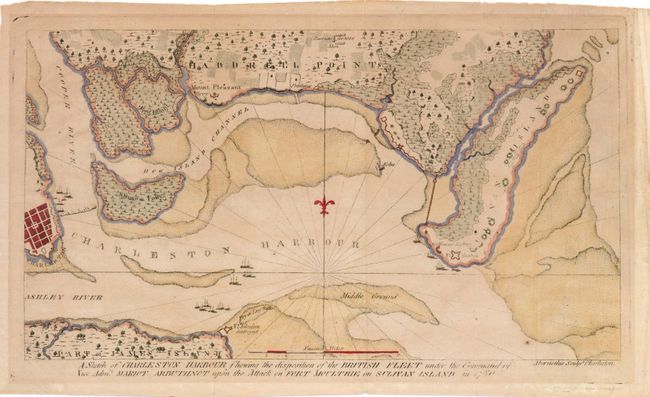
Auction 139, Lot 265
Subject: Charleston, South Carolina
Ramsay, David
A Sketch of Charleston Harbour Shewing the Disposition of the British Fleet under the Command of Vice Adm. Mariot Arbuthnot upon the Attack on Fort Moultrie on Sulivan Island in 1780, 1785
Size: 11.8 x 6.5 inches (30 x 16.5 cm)
Estimate: $1,200 - $1,500
Scarce Map of Charleston and the Battle at Fort Sullivan
Sold for: $700
Closed on 2/15/2012
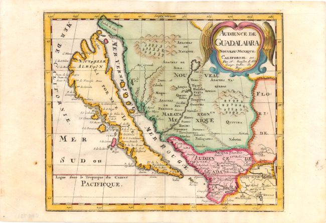
Auction 139, Lot 284
Subject: United States & Mexico, California
Sanson, Nicolas
Audience de Guadalaiara, Nouveau Mexique, Californie, &c., 1715
Size: 9.3 x 7.8 inches (23.6 x 19.8 cm)
Estimate: $1,000 - $1,200
Unsold
Closed on 2/15/2012
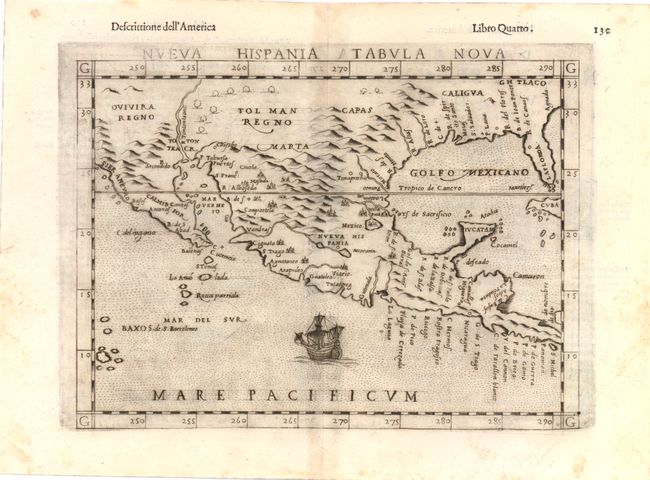
Auction 139, Lot 285
Subject: Southwest United States & Mexico
Ruscelli, Girolamo
Nueva Hispania Tabula Nova, 1598
Size: 9.8 x 7.5 inches (24.9 x 19.1 cm)
Estimate: $1,300 - $1,600
A Foundation Map for the American Southwest
Sold for: $950
Closed on 2/15/2012
16 lots