Catalog Archive
Auction 99, Lot 22

"Planisphaerium Terrestre Cum Globi du Coeleste Terr et Spaerium Armill. Etc.", Anon.
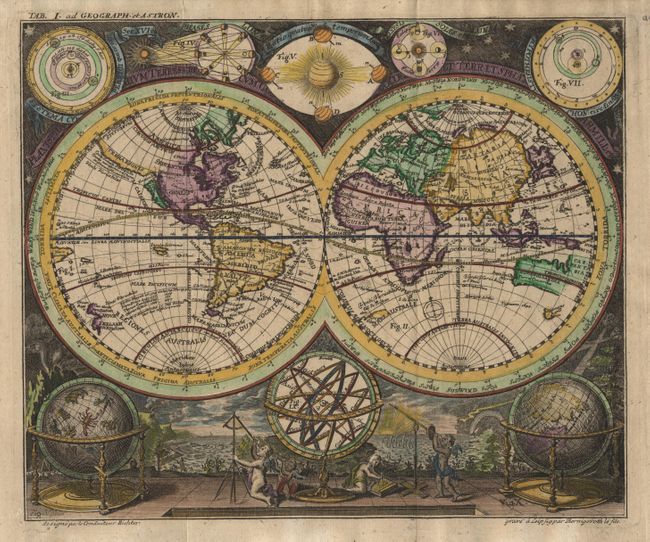
Subject: World

Period: 1700 (circa)

Publication:

Color: Hand Color

Size:
9 x 7.5 inches
22.9 x 19.1 cm
Download High Resolution Image
(or just click on image to launch the Zoom viewer)

Small and very decorative double hemisphere map. California is depicted as an Island with a flat northern coast. Australia includes the western and northern coasts and the discoveries of Van Diemen. There are numerous Pacific islands including much of the western coastline of New Zealand. Five astronomical diagrams decorate the top of the map. At the base are a pair of globes and an armillary sphere, which is surrounded by putti using a variety of scientific instruments. The background is taken from a map by Homann displaying natural phenomenon such as volcanoes, earthquakes, waterspouts and a rainbow. The map was included in a geography book as the upper margin includes "Tab. I. Ad Geograph. et Astron." Imprints at bottom are "designed par le Conducteur Richter" and "grave a Leipzig par Bernigeroth le fils". None of these names appear in Tooley's Dictionary of Mapmakers.

References: Not listed in Shirley.

Condition: A

Very crisp impression. Couple of tiny tears in margin, well away from map.

Estimate: $1,000 - $1,100

Sold for: $900

Closed on 6/12/2002

Archived