Catalog Archive
Auction 98, Lot 419

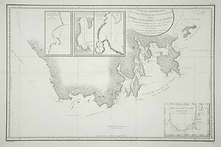
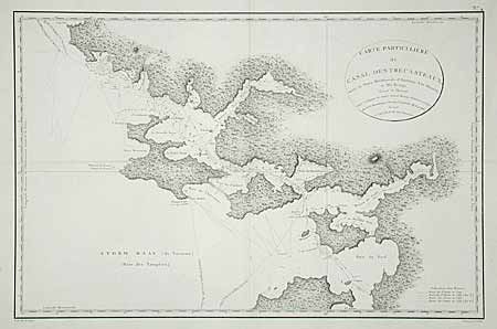
"[Lot of 2] Carte Generale de la Partie Meridionale de la Nouvelle Hollande, appelee Terre d'Anthony van Diemen… [and] Carte Particuliere du Canal Dentrecasteaux, entre la Terre Meridionale d'Anthony Van Diemen et l'Ile Bruny, Levee et Dressee", Beautemps-Beaupre, Charles Francois

Subject: Tasmania

Period: 1807 (published)

Publication: Atlas du Voyage de Bruny-Dentrecasteaux en 1792 et 1793

Color: Black & White

Size:
29.7 x 19.2 inches
75.4 x 48.8 cm
Download High Resolution Image
(or just click on image to launch the Zoom viewer)

Rarely seen pair of maps showing, in great detail, the areas of Tasmania explored by Admiral Bruny-Dentrescasteaux. The expedition to search for the lost expedition of La Perouse occurred in 1792-93, the height of the French Revolution. The expedition ended in the East Indies amid open clashes between the Royalists and the Republicans in the crew. The first chart centers on the area known as Storm Bay showing track date and excellent coastal topography and survey detail. Inset maps of the southern end of Van Diemens Land, Marion Bay and Frederick Hendrick Bay. The second is a more detailed chart of the area of modern Tasmania's South Bruny Island. Track of D' Entrecasteaux's ship shown along with excellent coastal and inland survey detail.

References:

Condition: A

Finely engraved and detailed on very thick paper. Both professionally backed to repair small split at fold intersection.

Estimate: $650 - $750

Sold for: $550

Closed on 3/6/2002

Archived