Catalog Archive
Auction 98, Lot 216

"Petersburg and Five Forks", U.S. War Department
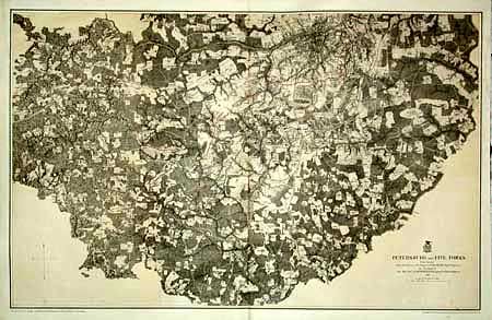
Subject: Virginia

Period: 1867 (dated)

Publication:

Color: Hand Color

Size:
33.5 x 21.1 inches
85.1 x 53.6 cm
Download High Resolution Image
(or just click on image to launch the Zoom viewer)

This superb Civil War military map was issued in a U.S. War Department report illustrating the Operations of the Armies of the Potomac & James. The maps were beautifully lithographed and hand colored by Julius Bien of New York. Each large-scale map features incredible detail including roads, houses, fences, names of inhabitants, vegetation, drainage, and relief hachures. Maj. J.E. Weyss drew these maps from surveys under the direction of Bvt. Brig. Gen. N. Michler and Bvt. Lieut. Col. P.S. Michie under the command of Bvt. Maj. Gen. A.A. Humphreys.

This shows the battlefield area, extending to Five Forks in the west and including a plan of Petersburg at street level. It is a very detailed plan on a scale 1.5 inches = 1 mile. Full-wash burnt umber background and colored troop entrenchments.

References: Phillips (A) Vol. 3, #3688-11.

Condition: A

A little marginal staining and a few tiny spots, still very good.

Estimate: $200 - $250

Sold for: $140

Closed on 3/6/2002

Archived