Catalog Archive
Auction 98, Lot 199

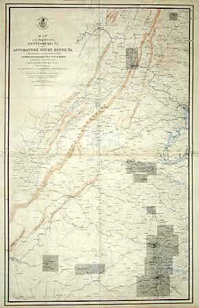
"Map of the Region between Gettysburg, PA. and Appomattox Court House, VA. Exhibiting the connection between Campaign and Battle-Field Maps prepared by Authority of the Hon. Secretary of War.", U.S. War Department

Subject: Pennsylvania

Period: 1869 (circa)

Publication:

Color: Hand Color

Size:
27 x 43.3 inches
68.6 x 110 cm
Download High Resolution Image
(or just click on image to launch the Zoom viewer)

This superb Civil War military map was issued in a U.S. War Department report illustrating the Operations of the Armies of the Potomac & James. The maps were beautifully lithographed and hand colored by Julius Bien of New York. Each large-scale map features incredible detail including roads, houses, fences, names of inhabitants, vegetation, drainage, and relief hachures. Maj. J.E. Weyss drew these maps from surveys under the direction of Bvt. Brig. Gen. N. Michler and Bvt. Lieut. Col. P.S. Michie under the command of Bvt. Maj. Gen. A.A. Humphreys.

This large and important is the index map made to accompany "Military maps illustrating the operations of the Armies of the Potomac and James…". Filled with a huge amount of Civil War detail and information. Extends to include Lynchburg in the southwest, Petersburg in the southeast and north through Washington and on to Gettysburg.

References: Stephenson (CW) #518 & S196; Phillips (A) #3688.

Condition: B

Printed on four sheets and joined on linen. Marginal staining in top margin, lightly toned from glue, and a few small areas of roughness at joins, but remarkable condition for a map of this size.

Estimate: $200 - $300

Sold for: $100

Closed on 3/6/2002

Archived