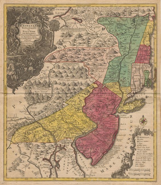
"Pensylvania Nova Jersey et Nova York cum Regionibus ad Fluvium Delaware in America sitis…", Seutter/Lotter
Subject: Colonial New England
Period: 1760 (circa)
Publication:
Color: Hand Color
Size:
19.2 x 22.2 inches
48.8 x 56.4 cm
This is a significant pre-Revolutionary War era map based on Lewis Evans’ map of 1749, one of the first and most important maps of the region. This German version had wider circulation than the Evans map and therefore significant influence on the European view of the colonies. It extends from New England to the estuaries of the Delaware and Chesapeake. The British colonies are confined east of the Appalachian Mountains and are depicted with some early, and not entirely accurate, boundary configurations. New Hampshire's entire eastern border is the Atlantic Ocean. Massachusetts is just below New Hampshire, but does not include Boston or Cape Code, which are shown as part of Connecticut. New York is divided into three sections and includes the western part of Massachusetts and Vermont. The map is graphically engraved to shows mountains, forests, colonial settlements and Indian villages. Two ornate (uncolored) cartouches fill opposite corners of the map: title is surrounded in an elaborate engraving featuring William Penn bartering with the natives and indigenous flora and fauna; distance scale and map key is enclosed in a decorative cartouche with a compass rose. Lotter engraved the map for his father-in-law Mattaeus Seutter probably in 1750. He then succeeded Seutter in 1756, and changed the cartouche imprint to his own for subsequent editions. This example bears the Lotter imprint.
References: McCorkle #750-4
Condition: A
Original color. Bit of minor foxing in margins with a few tiny spots in image - overall very near fine.