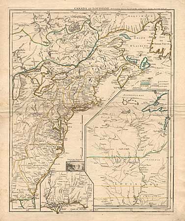
"Canada et Louisiane…", Le Rouge, George Louis
Subject: Colonial United States and Canada
Period: 1755 (dated)
Publication:
Color: Hand Color
Size:
19.5 x 24 inches
49.5 x 61 cm
First state of this important and scarce map issued at the outbreak of hostilities in the French and Indian Wars. The map depicts the entire eastern seaboard and the Great Lakes up to Lake Michigan with a great amount of detail. The coloring indicates the possessions of France, England and Spain. A large inset shows the upper Mississippi River valley with the important frontier forts and Indian nations. A smaller inset shows the lower Mississippi and Gulf coast. A small vignette of Niagara Falls adds further interest to this fascinating map. $2,400 RESERVE.
References: McCorkle # 755-23; Sellers and Van Ee #33.
Condition: A
Light soil in margins. Minor crease along centerfold, reinforced with tissue on verso.