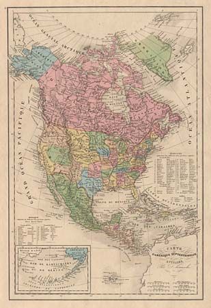
"Carte de l'Amerique Septentrionale et des Antilles", Delamarche, Francois Alexander
Subject: North America
Period: 1852 (circa)
Publication:
Color: Hand Color
Size:
11.4 x 17 inches
29 x 43.2 cm
Attractive map of the continent with early western borders. District of Oregon includes all of present day Washington, Oregon, Idaho and parts of Montana and Wyoming. New Mexico Territory has a long tail that extends north following the Rio Grande well into today's Colorado. Utah is a large and unnamed region. The Minnesota Territory is large and includes the Dakota area, all of which is within the "District des Sioux." Filled with the location of many Indian Districts and Tribes. Six distance scales in different units. Lists and locates shows 38 states and the territories. Another list locates 23 states of Mexico. Hand coloring indicates lands belonging to six nations. Inset of Mer de Kamchatka our de Bering shows the Aleutian Islands extending from 'Amerique Russe'. Fancy script lettered title.
References:
Condition: A
Good impression and very nice coloring. On sheet of sound paper with full margins.