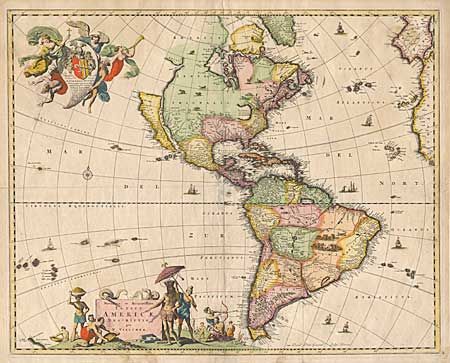
"Novissima et Accuratissima Totius Americae Descriptio", Visscher, Nicolas
Subject: Western Hemisphere
Period: 1680 (circa)
Publication:
Color: Hand Color
Size:
21.3 x 17.2 inches
54.1 x 43.7 cm
This handsome and important map of the Americas, with its distinctive decorative cartouches, had great influence on subsequent cartographers. Geographically it is largely derived from Blaeu’s 1648 world map and the Briggs 1625 map of THE ISLAND OF CALIFORNIA. The mainland coastline continues northeast toward the 'Straet Anian', which separates it from Anian. In the Southwest, the 'Rio del Norto' flows from a large interior lake, and empties into to the sea between the mainland and California. One of its most recognizable features is the huge open-ended lake in the vicinity of the Great Lakes. In South America, 'Parime Lacus' is prominent. The map is arrayed with wildlife throughout the land, a battle scene in South America, and the seas are filled with sailing ships. The bottom cartouche includes a scene of gold panning. The top cartouche bears a dedication to Cornelis Witsen, and depicts three angels carrying an Indian to heaven while banishing the devil.
References: Burden #332, State 2; McLaughlin #48; Tooley (America) p. 119.
Condition: B
Attractive old color. Some centerfold damage repaired with Japanese tissue on verso, couple of small worm holes and a worm track in upper cartouche all professionally filled.