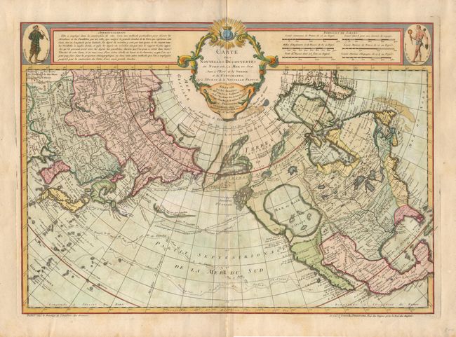
"Carte des Nouvelles Decouvertes au Nord de la Mer du Sud, Tant a l'Est de la Siberie et du Kamchatka, qu'a l'Ouest de la Nouvelle France", Delisle/Buache
Subject: North Pacific Ocean
Period: 1780 (circa)
Publication:
Color: Hand Color
Size:
25.2 x 17.8 inches
64 x 45.2 cm
This is Dezauche's reissue of Joseph Nicolas Delisle and Philippe Buache's rare 1750 map of the North Pacific. It is a cornerstone map of Alaska and the Pacific Northwest showing the discoveries of the Russians in 1723, 1732 and 1741, the tracks of Bering's first and second voyages, Delisle's voyage with Capt. Tchirikow in 1741, the track of De Frondat's voyage of 1709, and the route of the Galleons in 1743. The west coast of North America is entirely fictitious north of Cap Blanc with an enormous Sea of the West, Lac Valasco, Isle of Bernarda and a network of rivers and lakes making up most of a Northwest Passage. Title in rococo cartouche flankes a native of Kamchatka in upper left corner, native of Louisiana in upper right corner.
References: Tooley (America) p. 35 #105, plt. #22.
Condition: B
Light scattered foxing.