Catalog Archive
Auction 97, Lot 214

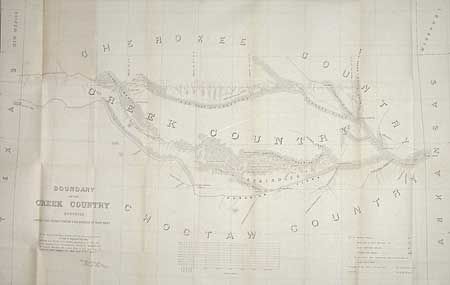
"Boundary of the Creek Country surveyed under the direction of the Bureau of Topographical Engineers", Sitgreaves, Lorenzo (Capt.)

Subject: Oklahoma

Period: 1849 (circa)

Publication: Hr Ex. Doc. 104, 35th Cong., 1st Session

Color: Black & White

Size:
37 x 23.7 inches
94 x 60.2 cm
Download High Resolution Image
(or just click on image to launch the Zoom viewer)

The area covered lies in the environs of the Canadian River and Red Fork of the Arkansas River in the Indian Territory. Extends from Fort Smith to the border with New Mexico Territory. Locates the lands of the Cherokee, Creek, Seminole and Choctaw Indians. Locates numerous forts and the roads connecting them including forts Smith, Coffee, Gibson and Old Fort Holmes. "Talasee" is shown at the site of Tulsa. Other interesting place names such as Post Oak & Black Jack. This map was issued with the "Northern and Western Boundary Line of the Creek Country" report by Sitgreaves and Lt. J.C. Woodruff. It is the only Creek Country map listed in the reference noted and is called by Fitch an "oversize rarity."

References: Phillips (M) p.251.

Condition: B

Folding as issued. A little toning along some fold and a couple of very short tears at fold intersections.

Estimate: $200 - $275

Sold for: $150

Closed on 12/5/2001

Archived