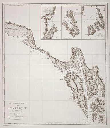
"Cote Nord-Ouest de l'Amerique Reconnue Par le Cap.e Vancouver. Vle Partie", Vancouver, George (Capt)
Subject: Alaska
Period: 1799 (published)
Publication: Voyage de Decouvertes a l' Ocean Pacifique
Color: Black & White
Size:
24.2 x 28.5 inches
61.5 x 72.4 cm
Beautifully engraved, large scale chart featuring the coastal topography with elevations from Mt. St. Elias to Cape Decision in Christian Sound covering the region of Southeastern Alaska where the future capital of the state would be located. Three insets at top: " Plan du Port Conclusion"; "Plan du Port Protection"; and Plan de l'entrée de Cross-Sound". During the summers of 1792-94, George Vancouver and the crew of the British naval ships Discovery and Chatham mapped the northwest coast of North America from Baja California to Alaska. Vancouver's voyage was the last, and longest, of the great Pacific voyages of the late eighteenth century. Taking the art and technique of distant voyaging to a new level, Vancouver eliminated the possibility of a Northwest Passage and his remarkably precise surveys completed the outline of the Pacific.
References:
Condition: A+
A few tiny spots of light foxing, still overall very fine condition for such a large sea chart.