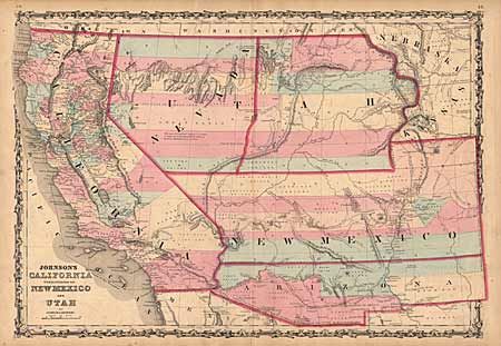
"Johnson's California Territories of New Mexico and Utah", Johnson & Browning
Subject: Southwestern United States
Period: 1861 (circa)
Publication: Illustrated Atlas
Color: Hand Color
Size:
24 x 16.8 inches
61 x 42.7 cm
The first and rarest map from Johnson's Southwest series. "Arizona" shows up in the southern 1/3 of New Mexico Territory. Here the Utah/Nevada border begins near the Great Salt Lake but wanders south-south-west from Lake Sevier. Filled with historical notes and notations. One note near Quartzite, Arizona refers to the area as being "fertile and abundantly timbered and well watered." Details the Emigrant road, the Hastings Road, and the routes of numerous explorers and military expeditions.
References:
Condition: B
Terrific color and a strong impression. A little marginal toning and some offsetting within the map, small tears in margins and split on bottom centerfold repaired with archival tape.