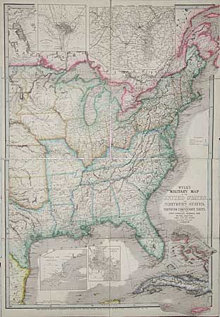
"Wyld's Military Map of the United States and the Southern Confederate States with the Forts, Harbours, Arsenals and Military Positions", Wyld, James
Subject: Southeastern United States
Period: 1861 (dated)
Publication:
Color: Hand Color
Size:
23 x 33 inches
58.4 x 83.8 cm
A colorful and detailed map of the United States east of the 100th meridian. Shows a good portion of Texas including San Antonio. Extends to show most of Cuba. Large insets show "City of Washington and District of Columbia", "Country Round Washington", "Pensacola Bay and its Fortifications", and "Charleston and the Harbor". Blue outlines indicate the "slave states". Filled with detail of roads, villages and cities, watershed and terrain, but specifically calling out arsenals, forts & military posts, and railways. West Virginia is still shown as part of Virginia. Original outline color.
References:
Condition: A
Dissected and mounted on linen, as issued. Very nice and wide outline coloring.