Catalog Archive
Auction 96, Lot 85

"A New Map of North America with the West India Islands divided according to the Preliminary Articles of Peace, Signed at Versailles, 20 Jan. 1783 wherein are particularly Distinguished The United States and the several Provinces, Governments &c…", Laurie & Whittle

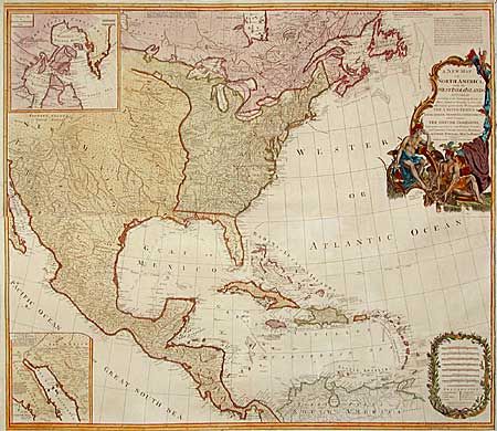
Subject: North America

Period: 1794 (dated)

Publication: General Atlas

Color: Hand Color

Size:
46 x 50 inches
116.8 x 127 cm
Download High Resolution Image
(or just click on image to launch the Zoom viewer)

Fabulous British wall map on four joined sheets. The map was originally drawn by Emanuel Bowen and engraved by John Gibson in 1755 to illustrate the French & Indian War. It was revised numerous times, going through a number of title changes and publishers over its long publication. Governor Pownall’s name first appeared on the map in 1777 and the map was updated to show the newly formed United States in 1783. It provides an extremely detailed view, locates hundreds of settlements and Indian villages and is filled with interesting notations. There are two inset maps - one showing the discoveries of Father Kino in California, the other showing Baffin and Hudson Bays. The large cartouche features Native Americas and indigenous animals.

References: Stevens & Tree (MCC-39) #49.

Condition: A

Original color, recently refreshed with added color to cartouche. Some minor tears professionally repaired and backed with light Japanese tissue.

Estimate: $2,750 - $3,250

Sold for: $2,750

Closed on 9/12/2001

Archived