Catalog Archive
Auction 96, Lot 25

"Diversi Globi Terr-Aquei Statione Variante et Visu Intercedente per Coluros Tropicorum per Ambos Polos…", Seutter, Matthias
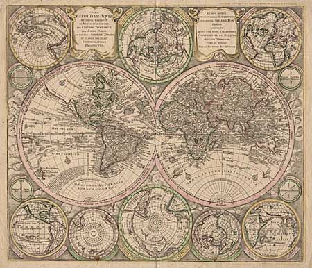
Subject: World

Period: 1730 (circa)

Publication:

Color: Hand Color

Size:
22.5 x 19.5 inches
57.2 x 49.5 cm
Download High Resolution Image
(or just click on image to launch the Zoom viewer)

Striking double hemisphere map surrounded by several smaller maps on various projections. CALIFORNIA IS AS AN ISLAND and is shown five times on the sheet. In Asia, Japan is shown in a bizarre shape, which is included with the fictional Terra Yedso. The map is filled with detail including the tracks of several explorers. The maps are set in a richly engraved background of clouds with numerous wind heads, lesser spheres and two cartouches. One of the most graphic 18th century world maps.

References:

Condition: B

Slightly faded original color, a few small stains in lower spheres, some tiny scattered worm holes. Marginal tears, including some missing paper in corners, all well away from the map.

Estimate: $2,500 - $2,750

Sold for: $1,700

Closed on 9/12/2001

Archived