Catalog Archive
Auction 96, Lot 123

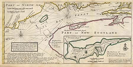
"A Description of the Bay of Fundy Shewing ye Coast, Islands, Harbours, Creeks, Coves, Rocks, Sholes, Soundings & Anchorings &c. observed by Nat. Blackmore in ye years 1711 and 1712. By Her Majesties Special Command", Moll, Herman

Subject: Canada and Maine

Period: 1745 (circa)

Publication: Atlas Minor

Color: Hand Color

Size:
17.2 x 8.2 inches
43.7 x 20.8 cm
Download High Resolution Image
(or just click on image to launch the Zoom viewer)

Fascinating map covering part of the coast of Maine, New Brunswick and Nova Scotia. Identified off the Maine coast are Mount Desart Rock, Great Manan I., Machias and the mouth of the St. Croix River. The map is filled with interesting notations to assist the navigator, such as "Mount Desart seen 15 leagues off in very clear weather" and "A hill like a Sugar Loafe, a good mark to steer in by N.N.E. when it is N. from you the Harbour is open." Large inset of "The Harbour of Annapolis Royal" in Nova Scotia. Third state with Moll's imprint replaced with the Imprint of Thomas Bowles as publisher.

References: Phillips (A) 574-54; Kershaw #763.

Condition: B

Minor light soil and old repairs on marginal fold splits, overall very good.

Estimate: $300 - $350

Sold for: $350

Closed on 9/12/2001

Archived