Catalog Archive
Auction 95, Lot 13

"Orbis Terrarum Nova et Accuratissima Tabula", Visscher, Nicolas
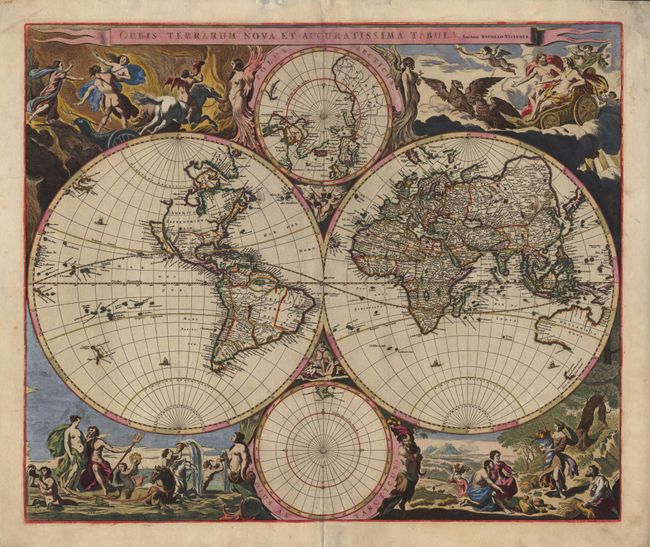
Subject: World

Period: 1658 (circa)

Publication:

Color: Hand Color

Size:
22.2 x 18.5 inches
56.4 x 47 cm
Download High Resolution Image
(or just click on image to launch the Zoom viewer)

Splendid large map regarded as the foundation for highly decorative Dutch world maps produced throughout the remainder of the 17th century. The twin hemispheres are surrounded by dramatic scenes drawn by Nicolaes Berchem. These superb engravings represent the rape of Persephone, Zeus being carried across the heavens in an eagle-drawn chariot, Poseidon commanding his entourage, and Demetre receiving the fruits of the Earth. At the top and bottom are smaller polar projections, each flanked by allegorical representations of Fire, Air, Water and Earth. Geographically the map is based on Blaeu's large world map of 1648 with minor variations in the ISLAND OF CALIFORNIA, shown here with a flat northern coast, and 'Anian' appearing adjacent to a strait leading within striking distance of the west shores of Hudson's Bay. In China, stippling is used for the first time in a general map to denote a desert, 'Xamo Desertum', just west of the Great Wall. The desert symbol was copied from Martini's 'Novus Atlas Sinensis' published in 1655. The map appeared in Jansson's Novus Atlas in 1658 and was used in several later atlases both by Jansson and Visscher, all in the unchanged state.

References: Shirley #406.

Condition: A

A superb, crisp example with original color and extensive original gold highlights. Map has been expertly backed with Japanese tissue, repairing centerfold.

Estimate: $7,500 - $9,500

Sold for: $5,500

Closed on 6/13/2001

Archived