Catalog Archive
Auction 93, Lot 17

"Nova Totius Terrarum Orbis Geographica ac Hydrographica Tabula", Hondius/Jollain
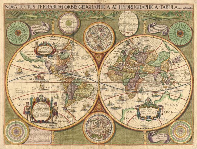
Subject: World

Period: 1671-3 (circa)

Publication:

Color: Hand Color

Size:
22 x 16.5 inches
55.9 x 41.9 cm
Download High Resolution Image
(or just click on image to launch the Zoom viewer)

Splendid copper engraved map depicting the world in two hemispheres with astronomical charts and diagrams in a fully engraved decorative surround. This is a rare, and apparently unrecorded, late variant of this map published by Francis Jollain (imprint: A Paris Chez Jollain rue St. Jacques a la ville de Cologne). The Hondius world map of 1617 was the prototype for a series of maps by French publishers who combined Hondius' geographical information with the more scientific border decorations from Boisseau's map of 1636. The map depicts the discovery of the Le Maire Strait at the tip of South America. In North America, the St. Lawrence River runs nearly the entire width of the continent, terminating in a large lake, and Hudson Bay is shown (after Gerritsz). In Asia, Korea is shown as an island, the northern coast of New Guinea is more properly located and there is a large "Terre Australle Incognue". The surrounding engravings include a pair of celestial charts, circular diagrams containing the compass points, the names of the winds, the climatic zones, the heavenly orbits and a thirty-year calendar. The map is richly adorned with a variety of decorations including three cartouches, each with figures, numerous sailing ships, sea monsters, flying fish and a depiction of Neptune. Ref: Shirley #354, 370 and Chart VI. There are several differences between this state and the editions mentioned by Shirley: the spelling in title "Hydrographic" is correct; flanking the top celestial chart are a circular diagram with a division of the world in climatic zones, called "Premiere Figure", and an oval containing "Explanation de la I re. Figure"; the calendar in the lower left corner begins with 1671 (instead of 1637); and the small banner at the right has been replaced by a square areas with an example of calculating with the calendar; and finally the Latin text in the large cartouche has been replaced with a French "Instruction du Calendrier". The year 1673 has been chosen to illustrate the use of the calendar. It is therefore likely that the present state of the map was published between 1671 and 1673. All variants listed by Shirley as scarce or rare.

References:

Condition: A

Paper edges are a bit ragged with a tiny bit of light foxing in margins, image fine.

Estimate: $11,000 - $12,000

Sold for: $8,250

Closed on 12/6/2000

Archived