Catalog Archive
Auction 92, Lot 68

"Nova Totius Americae Descriptio", Wit, Frederick de

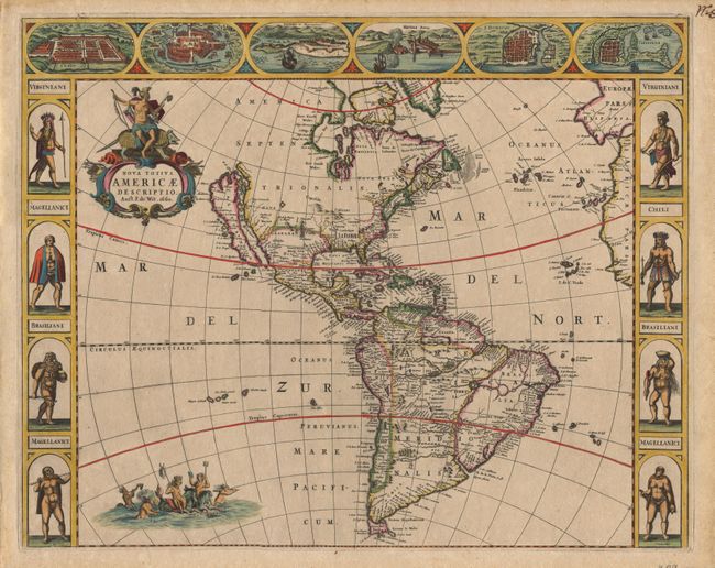
Subject: Western Hemisphere

Period: 1660 (dated)

Publication:

Color: Hand Color

Size:
21.5 x 17 inches
54.6 x 43.2 cm
Download High Resolution Image
(or just click on image to launch the Zoom viewer)

An uncommon and splendid carte-et-figures map of the Americas. The map combines many different sources including the Luke Foxe model of the ISLAND OF CALIFORNIA. The only hint of the Great Lakes is a small 'L Contenant' at the end of the St. Lawrence River. 'New Neder Land' occupies the eastern seaboard and there is no mention of any English settlement other than the name Virginia. In South America a large river and lake system provides the boundary of Brazil. The decorations were taken from van den Keere's map of 1614. The figures at sides depict the natives of Virginia, Magellanica, and Brazil, and the cities across the top include Cusco, Mexico, Olinda, Havana, S. Dominique, and Cartegena. The map is further embellished with a title cartouche bearing a native Indian mounted on an armadillo, and Neptune frolicking in the Pacific with mermaids and sea horses. This is the scarce first state of this separately issued map. The map is backed with 17th century paper, giving it extra sturdiness. It was bound at the left and therefore has no centerfold.

References: Burden #356; McLaughlin #24; Tooley (America) #18.

Condition: A+

Fine original color and condition.

Estimate: $5,000 - $6,000

Sold for: $6,000

Closed on 9/13/2000

Archived