Catalog Archive
Auction 92, Lot 26

"A New & Correct Map of the Whole World Shewing ye Situation of its Principal Parts...With the most Remarkable Tracks of the Bold Attempts which have been made to find out the North East & Northwest Passages…", Moll, Herman
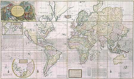
Subject: World

Period: 1719 (dated)

Publication:

Color: Hand Color

Size:
47 x 27.8 inches
119.4 x 70.6 cm
Download High Resolution Image
(or just click on image to launch the Zoom viewer)

A very large, spectacular map on Mercator's projection. The cartographic details include the prominent INSULAR CALIFORNIA and recent discoveries in Australasia and northern Japan. There is a large inset of the North Pole depicting the potential regions where either a northwest, or northeast, passage may be found. Another inset world map shows the magnetic variations of the compass in the Atlantic and Indian oceans based on recent English observations. The tradewinds are graphically shown in the oceans and the map is filled with fascinating comments and annotations. The large title cartouche is surrounded by explorers, natives, animals and allegorical figures. The map consists of 4 sheets joined. $3,500 RESERVE

References:

Condition: A

Lovely color and condition, with professionally reinforced folds.

Estimate: $4,200 - $4,500

Sold for: $3,750

Closed on 9/13/2000

Archived