Catalog Archive
Auction 91, Lot 89

"Le Canada ou Partie de la nouvelle France, Contenant la Terre de Labrador la Nouvelle France, les Isles de Terra Neuve, de Nostre Dame &c.", Mortier, Pierre
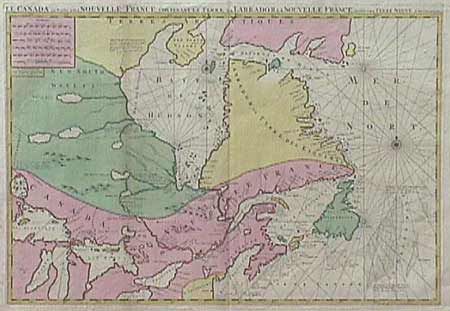
Subject: Canada

Period: 1693 (circa)

Publication: Suite du Neptune Francois ou Atlas Nouveau

Color: Hand Color

Size:
30.7 x 22 inches
78 x 55.9 cm
Download High Resolution Image
(or just click on image to launch the Zoom viewer)

First state of this large, striking map of the region to the north of Lake Superior and eastward. Pierre Mortier based this map on Jaillot's map of 1685, which incorporated information from the manuscripts of Jolliet, Hennepin, and Franquelin. Lake Superior is based on the Dablon prototype and Hudson Bay is derived from English sources with Port Nelson shown in roughly the correct location.

References: Verner & Stuart Stubbs, #9; Kershaw #176.1

Condition: A+

An extremely fine copy in original, full wash color with two beautiful compass roses.

Estimate: $1,800 - $2,000

Sold for: $1,800

Closed on 6/14/2000

Archived