Catalog Archive
Auction 91, Lot 88

"La Terra de Hochelaga Nella Nova Francia",
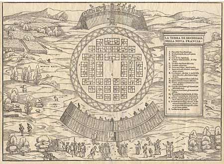
Subject: Canada

Period: 1556 (published)

Publication: Navigationi et Viaggi

Color: Black & White

Size:
14.7 x 10.8 inches
37.3 x 27.4 cm
Download High Resolution Image
(or just click on image to launch the Zoom viewer)

Rare, first edition of the first plan of the site of Montreal showing the Indian settlement visited by Cartier in 1535-36. This is the first time the name "Monte Real" appears on a map. The village is laid out in a circular form and protected by wooden barriers. Cartier and his crew are pictured in the foreground being greeted by their Indian hosts. The woodblock for this map, and the others in the "Navigationi et Viaggi" were destroyed by fire in 1557. Ref: Kershaw #16, Lamb #449, Schwartz & Ehrenberg, p. 63. A fine, early impression. Professional repair of centerfold with a tiny bit of expert facsimile.

References:

Condition: A

Estimate: $1,200 - $1,400

Sold for: $950

Closed on 6/14/2000

Archived