Catalog Archive
Auction 91, Lot 75

"Amerique Septentrionale Par N. Sanson d'Abbeville Geog. Du Roy A Paris Chez l'Auteur et chez Pierre Mariette rue S. Iacques a l Esperace 1650",

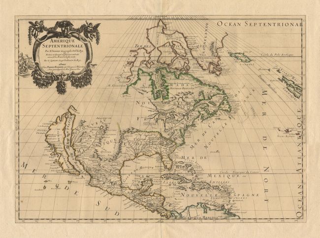
Subject: North America

Period: 1669 (dated)

Publication: Carte Generales de toutes les parties du Monde

Color: Hand Color

Size:
21.5 x 15.3 inches
54.6 x 38.9 cm
Download High Resolution Image
(or just click on image to launch the Zoom viewer)

This map replaced Nicolas Sanson's landmark map of 1650 in this atlas. Guillaume Sanson, in partnership with Pierre Mariette, based this map on his father's 1666 wall map of North America. Cartographically it is an amalgam of Sanson's maps of "Le Canada, ou Nouvelle France" and "Le Nouveau Mexique, et La Floride". Lake Erie is shown in a recognizable form and the entire Great Lakes network is shown in greater detail, although still with the western lakes open-ended. On the East coast, Long Island is shown and the shape of the Outer Banks is improved. The ISLAND OF CALIFORNIA is now shown in the form originating with Luke Foxe's map of 1635, and popularized by Sanson. Several Indian tribes are identified in New Mexico where the "R. del Norte" (Rio Grande) mistakenly flows from an interior lake and empties into the "Mar Vermeio ou Mer Rouge" (Gulf of California). In the Atlantic, Iceland now appears, as well as a bit of Britain. First state. Ref: Burden #404; Tooley (America), p. 114; and McLaughlin #45. A superb early impression with original outline color and wide margins. $2,400 RESERVE

References:

Condition: A+

Estimate: $3,000 - $4,000

Sold for: $2,750

Closed on 6/14/2000

Archived