Catalog Archive
Auction 191, Lot 45

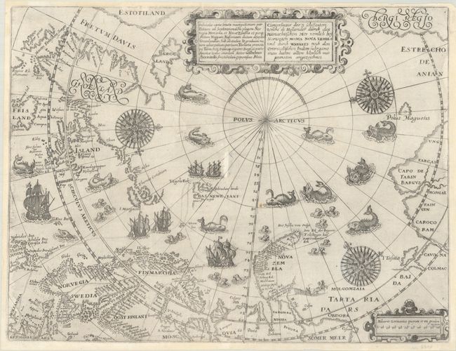
Early Map of North Pole Depicting Barentsz' Expedition

"Deliniatio Cartae Trium Navigationum per Batavos ad Septentrionalem Plagem Norvegia Moscovia et Nova Zembla... / Conterfactur der 3 Schiffarten Welche di Hollander durch das Mitnachtischen Mer Nemlich bey Norwegen Mosca Nova Zembla...", Bry, Theodore de

Subject: North Pole

Period: 1601 (circa)

Publication: Petits Voyages, Part III

Color: Black & White

Size:
14.3 x 11 inches
36.3 x 27.9 cm
Download High Resolution Image
(or just click on image to launch the Zoom viewer)

This copper engraving is from a remarkable series of publications, illustrating voyages of discovery and travels of exploration to various parts of the world. The project was begun by Theodore de Bry of Frankfurt, in 1590 and was to continue for another 54 years. They became known collectively as the Grands Voyages (to America and the West Indies) and the Petits Voyages (to the Orient and the East Indies). De Bry died after the first six parts of the Grands Voyages were completed. The project was completed initially by his widow and two sons, Johann Theodore de Bry and Johann Israel de Bry, then by his son-in-law, Matthaus Merian in 1644.

This is one of the most decorative early maps of the North Pole, and depicts the voyage of Willem Barentsz on his quest to find a Northeast passage to the East Indies. This map is a reduced-size edition of Barentsz' 1598 map of the region and was the first to show Spitsbergen, here called Das Newe Lant. Barentsz never reached further east than Novaya Zemlya, where his ship became trapped in the ice and he and his crew were forced to survive the harsh winter. The crew dismantled the ship to build a shelter and two smaller open boats, which they used to return to Holland after the ice melted. Unfortunately Barentsz fell ill and died shortly after the ships departed Novaya Zemlya.

The map extends from Estotiland (Labrador) to Bergi Regio (the northwestern coast of North America) and the Strait of Anian and shows the track of Barentsz' third voyage from Holland to Nova Zembla. It includes excellent detail along the coasts of Scandinavia. Greenland, Iceland and Novaya Zemlya are partially delineated, and the mythical island of Frisland is included at far left. The ocean is filled with decorative illustrations of sailing ships, sea monsters, and compass roses. In Tartaria is a small image of a reindeer pulling a Laplander on a sleigh.

Published in the 1599 and 1616 German editions and the 1601 and 1629 Latin editions of De Bry's Petits Voyages. This is the second state of the map, which was first published in 1601, with the addition of the title in Latin adjacent to the German title, as well as several place names added and the the scale of miles filled in at bottom right.

References: Ginsberg #47.

Condition: B+

A nice impression on a bright sheet with a double-sided cross watermark. There is a small hole at center and a tiny chip at top that have been professionally repaired with a minor amount of the rhumb lines replaced in facsimile.

Estimate: $3,500 - $4,250

Sold for: $4,000

Closed on 2/8/2023

Archived