Catalog Archive
Auction 190, Lot 69

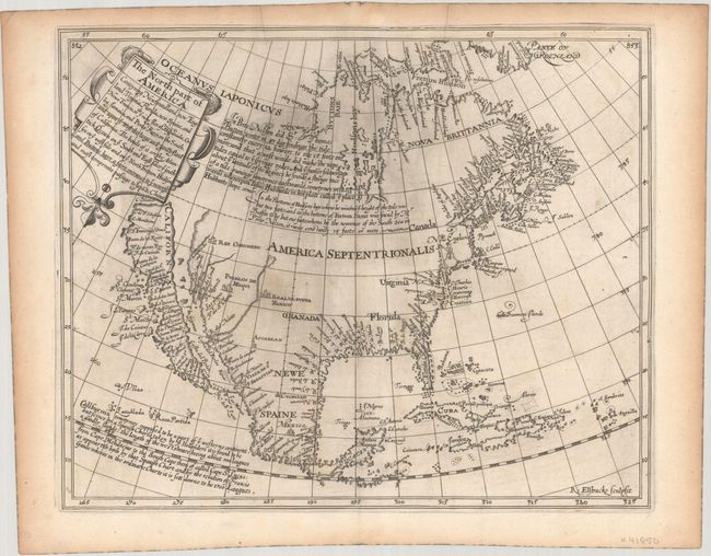
First English Map to Show California as an Island

"The North Part of America Conteyning Newfoundland, New England, Virginia, Florida, New Spaine, and Nova Francia...", Briggs, Henry

Subject: Colonial North America

Period: 1625 (circa)

Publication: Hakluytus Postumus or Purchas His Pilgrimes

Color: Black & White

Size:
13.8 x 11.2 inches
35.1 x 28.4 cm
Download High Resolution Image
(or just click on image to launch the Zoom viewer)

This is the first English map, and very likely the very first map overall, to show California as an Island and features a flat northern coastline. Burden aptly describes this map as "the progenitor of the most persistent of cartographic misconceptions," as many scholars believe that Briggs' map was in fact the source for Abraham Goos' 1624 map of the continent that by publication date was the first map to show California as an island. The most compelling evidence for this argument on Goos' map is the lack of a Dutch presence in New England and the use of Hudsons R. which was the only Dutch map of the period to use this English name. If Briggs' map was in fact issued earlier, his would also be the first to name Hudson Bay, Hudson River, and Cape Cod among others. It was engraved by Reynold Elstracke with his imprint in the lower right corner and locates Plymouth, James Citti, and Real De Nueva Mexico (Santa Fe). No Great Lakes are depicted. There is a large Oceanus Iaponicus to the west of Hudson Bay with two paragraphs of text demonstrating knowledge of recent explorers seeking a Northwest Passage. The third paragraph at lower left relates to California and begins "California sometymes supposed to be a part of ye westerne continent, but scince by a Spanish Charte taken by ye Hollanders it is found to be a goodly Ilande..." indicating that the theory began with Spanish explorers. Vizcaino's voyage of 1602-03 is noted with the place names P.S. Diego and S. Clemet appearing for perhaps the first time. Friar Antonio de la Ascension was on Vizcaino's ship, whose written account is most likely the origin of the insular California theory.

The map was featured in Henry Briggs' work entitled A Treatise of the North-West Passage to the South Sea, Through the Continent of Virginia, and by Fretum Hudson, which was issued in the third volume of Purchase His Pilgrimes with page numbers 852 and 853 in the top corners of the map.

References: Burden #214; McLaughlin #2; Wagner (NW) #295; Wheat (TMW) #38.

Condition: A

A dark impression with some minor printer's ink residue at center and light toning along the sheet edges.

Estimate: $16,000 - $19,000

Sold for: $11,500

Closed on 11/16/2022

Archived