Catalog Archive
Auction 189, Lot 6

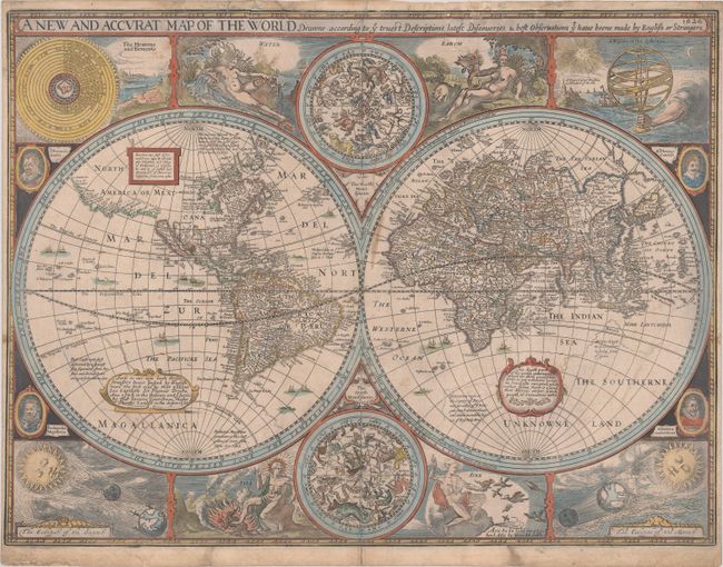
First State of Speed's Double-Hemisphere World Map with Rare Blank Verso

"A New and Accurat Map of the World Drawne According to ye Truest Descriptions Latest Discoveries & Best Observations yt Have Beene Made by English or Strangers", Speed, John

Subject: World

Period: 1626 (dated)

Publication:

Color: Hand Color

Size:
20.6 x 15.5 inches
52.3 x 39.4 cm
Download High Resolution Image
(or just click on image to launch the Zoom viewer)

This desirable and beautiful double-hemispheric world map carries the imprint of George Humble. The map is dated 1626 but it was known to be published in editions of A Prospect of the Most Famous Parts of the World through 1632 with this imprint. This map is based on William Grent's rare, separately issued map of 1625 (Shirley #313). It is considered one of the earliest published world maps to be printed in English, and is the first atlas map to show the cartographic curiosity of California as an island, which persisted for nearly 100 years. It was also one of the first to show the settlement of New Plymouth. The coastline in North America is blank east of California and swings wildly to the west in the northern regions of Canada and Alaska. The Straits of Magellan are inaccurately shown and Tierra de Fuego is left open to the west. The Southerne Unknowne Land shows the large conjectured continent covering much of the southern hemisphere. The map is beautifully engraved and highly detailed throughout. The engraver is unknown but Shirley acknowledges it was most likely Abraham Goos. This highly decorative production is surrounded by two celestial hemispheres, figural allegorical representations of Water, Earth, Air and Fire, plus portraits of Ferdinand Magellan, Oliver vander Noort, Thomas Cavendish and Sir Francis Drake. The corners are filled with an astronomical table, an armillary sphere, and eclipses of the sun and moon. With several lengthy notes including comments on the South Pole and the Straits of Magellan, Sir Francis Drake and others. Shirley says this map was not as widely disseminated as those from contemporary Dutch cartographers and was uncommon outside the UK. This is a particularly rare edition with a blank verso; although most examples of this map were published with English text on verso in Speed's A Prospect of the Most Famous Parts of the World, this appears to be a separately issued version of the first state.

References:

Condition: B+

On a sheet with a Strasbourg bend & lily watermark and narrow side margins, as issued. Edge tears along the top edge and a 6.5" centerfold separation at bottom have all been repaired on verso with archival materials. There are some errant ink marks near the center and light soiling.

Estimate: $14,000 - $16,000

Sold for: $11,000

Closed on 9/14/2022

Archived