Catalog Archive
Auction 189, Lot 671

First State in Full Contemporary Color

"Mar del Zur Hispanis Mare Pacificum", Jansson, Jan

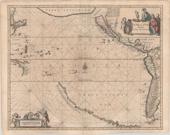
Subject: Pacific Ocean

Period: 1650 (circa)

Publication: Nouvel Atlas

Color: Hand Color

Size:
21.4 x 17.3 inches
54.4 x 43.9 cm
Download High Resolution Image
(or just click on image to launch the Zoom viewer)

This significant map covers the whole Pacific Ocean along with the western coastlines of the Americas, Japan, and a bit of New Guinea and Cape York, Australia, showing the recent Dutch discoveries there. The top of the chart is dominated by a large landmass labeled Terra Incognita. A large Island of California appears, based on the Briggs type, most probably using Abraham Goos' map as a model. A curious chain of islands thread their way across the South Pacific with a legend that identifies these islands as being discovered by Hernando Galego in 1576. The chart is centered on a compass rose with rhumb lines and is ornamented with a great title cartouche with Asian figures and the distance scale with putti using navigational instruments. This is the first state with French text on verso, published between 1650-57.

References: Burden #292; McLaughlin #11; Tooley (Amer) p. 114, #10; Van der Krogt (Vol. I) #0600:1; Wagner (NW) #359.

Condition: B+

Full contemporary color. There is some uneven toning and faint dampstains at bottom that have been backed with Japanese tissue.

Estimate: $1,600 - $1,900

Sold for: $800

Closed on 9/14/2022

Archived