Catalog Archive
Auction 189, Lot 584

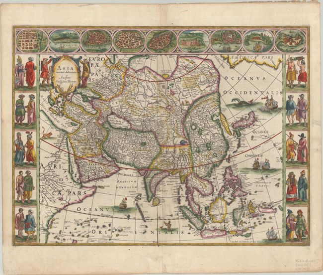
Magnificent Carte-a-Figures Map of Asia in Full Contemporary Color

"Asia Noviter Delineata", Blaeu, Willem

Subject: Asia

Period: 1643 (circa)

Publication: Theatre du Monde ou Nouvel Atlas

Color: Hand Color

Size:
21.9 x 16.3 inches
55.6 x 41.4 cm
Download High Resolution Image
(or just click on image to launch the Zoom viewer)

This is one of the most famous 17th century maps of the continent of Asia. It is surrounded by a beautiful carte-a-figures border and is richly ornamented with animals, sea monsters, and sailing ships. The eastern coastline of Asia is severely truncated, Korea is shown as an island, and Japan is depicted on the Ortelius-Teixeira model. The Indian subcontinent is too narrow and the islands of Indonesia are very sketchy. A large island labeled Ceiram probably represents the western part of New Guinea. In the interior, the Caspian Sea is oriented on an east-west axis and there are several large erroneous lakes in China including the mythical Chiamay Lacus. The frieze across the top features vignettes of the cities of Candy, Calecut, Goa, Damascus, Jerusalem, Hormuz, Banten, Aden, and Macao. The inclusion of Banten reflects the emergence of the Dutch as a major commercial power in the East Indies. The side panels flanking the map depict costumed figures of the various Asian peoples. This is a later edition with evidence of a crack in the copperplate at bottom center. French text on verso, published between 1643-50.

References: Van der Krogt (Vol. II) #8000:2; Walter #25; Yeo #24.

Condition: A

A nice impression with full contemporary color on a bright, watermarked sheet with a hint of soiling and some minor creasing along the centerfold at bottom. There are a few tiny chips and an archivally repaired tear in the top margin, and small remnants of hinge tape on verso.

Estimate: $3,500 - $4,250

Sold for: $2,500

Closed on 9/14/2022

Archived