Catalog Archive
Auction 187, Lot 499

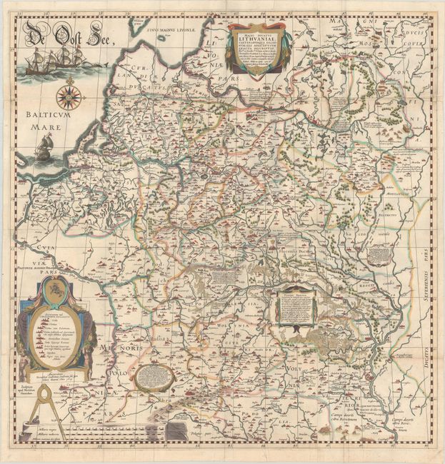
Impressive Wall Map of the Grand Duchy of Lithuania

"Magni Ducatus Lithuaniae, Caeterarumque Regionum Illi Adiacentium Exacta Descriptio...", Blaeu, Willem

Subject: Eastern Europe, Lithuania & Ukraine

Period: 1634 (circa)

Publication:

Color: Hand Color

Size:
28.9 x 29.6 inches
73.4 x 75.2 cm
Download High Resolution Image
(or just click on image to launch the Zoom viewer)

This superb 4-sheet map is based on an important map of the Duchy of Lithuania commissioned by Prince Michael Radziwill in 1586. The map was the most accurate map of Lithuania and served as a resource for all other maps of the region for 150 years. Blaeu first published his four-sheet map of Lithuania along with a two-sheet map of the Dnieper River in 1613 with the imprint "Guilhelmus Janssonius" below the legend at bottom left. He later added the name "Blaeu" to his name in order to differentiate himself from his rival, Jan Jansson. The map of Lithuania, which had been engraved by Hessel Gerritsz, first appeared in 1631, in Blaeu's Appendix, and were subsequently published in various editions through 1670.

The wall map of the Grand Duchy of Lithuania covers the region from Riga to Smolensk in the north, and from Cracow to Kiev in the south. The map provides an incredible amount of information on hundreds of cities and towns of all sizes, political boundaries, and the extensive system of rivers in the region. Also included are a number of historical notations and two vignettes illustrating important battles west of Smolensk and between Braclaw (Bratslav) and Cherkasy (at bottom right). It is the first published map to include the name “Ukraina.” Based on surveys initiated by Crown Prince Nicholas Christopher Radziwill after the Polish-Lithuanian Commonwealth gained control of most of Ukraine, it greatly improved upon the mapping of the region with the addition of new settlements and updates to the river systems. The region west of Kiova (Kyiv) is called Volynia Ulterior, quae tum Ukraina tum nis ab aliis volcitatur. The map is handsomely embellished with several cartouches, three galleons and a sea monster in the Baltic Sea, a large compass rose, and a distance scale on parchment with a caliper. Blank verso. On two full sheets and two half sheets, joined. This map was recently featured in our March 2022 newsletter article on the history of the mapping of Ukraine.

References: Ukraine in Old Maps pp. 184-87; Van der Krogt (Vol. II) #1730/I:2A.

Condition: B

A sharp impression with gilt highlights, issued folding with a light stain near center. There is a strip along the horizontal fold at top, measuring around 0.25 - 0.5" in width, that has been replaced in facsimile. There are archival repairs to a few separations along the edges of the sheet and around the lower joint, as well as to two 2" tears at bottom center (within "Wolynia Citerior").

Estimate: $3,500 - $4,250

Sold for: $3,250

Closed on 4/27/2022

Archived