Catalog Archive
Auction 186, Lot 694

Ortelius' Important Map of Southeast Asia

"Indiae Orientalis, Insularumque Adiacientium Typus", Ortelius, Abraham

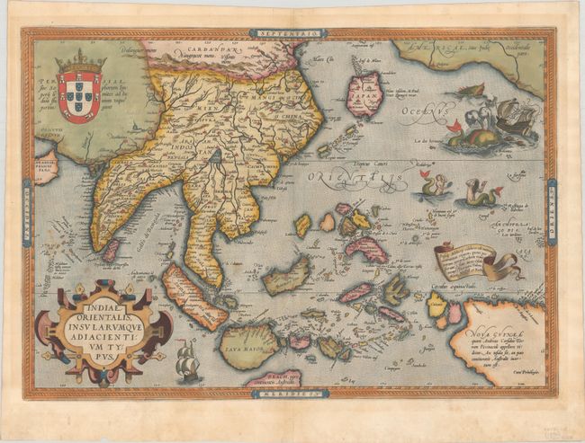
Subject: Southern & Southeast Asia

Period: 1572 (circa)

Publication: Theatrum Orbis Terrarum

Color: Hand Color

Size:
19.6 x 13.6 inches
49.8 x 34.5 cm
Download High Resolution Image
(or just click on image to launch the Zoom viewer)

Ortelius' important map of Southeast Asia, based on Mercator's 1569 World map, shows how sketchy the available information was concerning the region. The East Indies are presented as a randomly scattered archipelago with Java and Borneo particularly misshapen. Taiwan is mapped for the first time as I. Fermosa in the 'tail' of kite-shaped Japan's Lequaio islands. The fictitious Chyamai lacus is the source of a network of major rivers in Southeast Asia. Beach pars, a presumed promontory of the great southern continent based on Marco Polo's account, protrudes into the bottom of the map. In the upper right corner, America makes an appearance with the three coastal cities of Quivira, Cicuie, and Tiguex. Near the shore lies a ship being menaced by a pair of sea monsters, while twin mermaids preen before each other near the Ladrone Islands. French text on verso, published in 1572 or 1574.

References: Van den Broecke #166; Suarez (SE Asia), pp. 164-69.

Condition: B+

A crisp impression on a faintly toned sheet with a bunch of grapes watermark, a few spots of soiling, and a couple of tiny tears along the edges of the sheet. There are small remnants of paper tape in the corners of the sheet on verso.

Estimate: $2,500 - $3,250

Sold for: $1,900

Closed on 2/9/2022

Archived