Catalog Archive
Auction 186, Lot 676

Ortelius' Influential Map of Japan

"Iaponiae Insulae Descriptio. Ludoico Teisera Auctore", Ortelius, Abraham

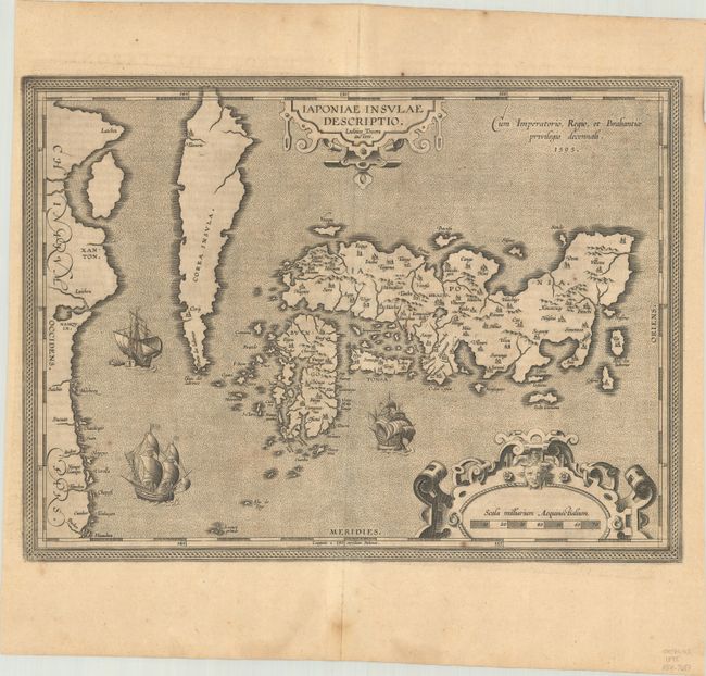
Subject: Japan & Korea

Period: 1595 (dated)

Publication: Theatrum Orbis Terrarum

Color: Black & White

Size:
19 x 14 inches
48.3 x 35.6 cm
Download High Resolution Image
(or just click on image to launch the Zoom viewer)

This landmark map was the first map of Japan published in a European atlas. Ortelius received the map from Ludovico Teixeira, a Portuguese Jesuit cartographer and mathematician. While Teixeira had not personally traveled to Japan, he obviously had access to Japanese sources as the map presents the first reasonably accurate and recognizable depiction of the island nation with numerous Japanese place names. Korea appears as an island tapering to a point labeled Punta dos ladrones. The map is elegantly embellished with three large galleons, two elaborate cartouches, and a boldly engraved border. This influential map was to become the basis for many other cartographers' maps of Japan for more than fifty years. Italian text on verso, published in either 1608 or 1612.

References: Van den Broecke #165; Walter OAG #5, plt. 19.

Condition: B+

A dark impression with a few spots of foxing and a faint dampstain along the centerfold at bottom, not affecting the image.

Estimate: $2,000 - $2,300

Sold for: $1,300

Closed on 2/9/2022

Archived