Catalog Archive
Auction 186, Lot 385

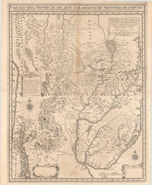
Pre-Publication Proof of Extremely Rare Jesuit Map of Paraguay

"Paraquariae Provinciae Soc. Jesu cum Adjacentib. Novissima Descriptio...",

Subject: Central South America, Paraguay

Period: 1722 (dated)

Publication:

Color: Black & White

Size:
21.9 x 28.4 inches
55.6 x 72.1 cm
Download High Resolution Image
(or just click on image to launch the Zoom viewer)

This is Jesuit Juan Francisco Davila's extremely rare map of the the Jesuit province of Paraguay and its surrounding regions. It is likely a pre-publication proof, with some blank and unfinished cartouches and an incomplete date of "172" in the dedicatory cartouche at top right. The product of a decade's work, Brother Davila completed the map to aide the Superior General in transferring personnel to the region. It was the most comprehensive map of the region up to that point. The finished map was published in Rome in 1726 and was copied by other publishers such as Joannes Petroschi and Mattias Seutter.

Between 1609 and 1780, the Roman Catholic Society of Jesus (the Jesuits) established an autonomous Christian Indian state on the territory of present-day Paraguay, Uruguay, and parts of Argentina and Brazil. The map depicts this region, spanning from the Peruvian Andes north of Cusco to the mouth of the Rio de la Plata. It covers present-day Paraguay, Uruguay, and Bolivia and large areas of Peru, Chile, Brazil, and Argentina. Place names include Lag de Chucuito (Lake Titicaca), La Paz, Cochabamba, Potosi, Santiago, Cordoba, (Asuncion), Monte Video, and Buenos Aires. There is rich topographical detail of the region, and it locates major missionary trails, missions, native settlements, and existing and destroyed Spanish towns. The mythical lake Xareyes is prominent in Brazil. There are four decorative cartouches: a dedicatory cartouche at top right dedicated to Michelangelo Tamburini, Superior General of the Society of Jesus from 1706 to 1730; a cartouche featuring Latin verse at center left; and two blank cartouches at bottom that would later include a distance scale and key. Two ornate compass roses complete the composition. Printed on 2 joined sheets.

References:

Condition: B+

A crisp impression with a 1.5" fold separation at center that has been repaired with archival materials on verso, light toning along the vertical fold, a printer's crease near the center of the image, and some light stains.

Estimate: $4,000 - $4,750

Unsold

Closed on 2/9/2022

Archived