Catalog Archive
Auction 185, Lot 665

Blaeu's Map of China Featuring Fictitious Lakes and Rivers in Full Contemporary Color

"China Veteribus Sinarum Regio nunc Incolis Tame Dicta", Blaeu, (Family)

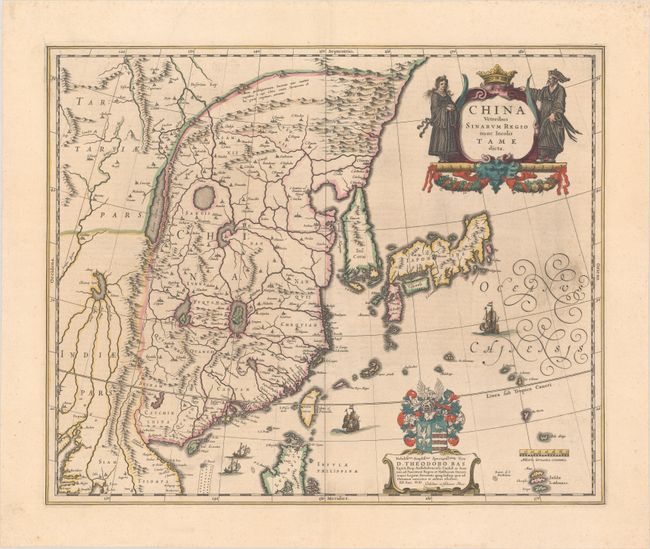
Subject: China, Korea & Japan

Period: 1641 (circa)

Publication: Novus Atlas

Color: Hand Color

Size:
19.8 x 16.2 inches
50.3 x 41.1 cm
Download High Resolution Image
(or just click on image to launch the Zoom viewer)

Several large lakes dominate the topography of this elegantly engraved map of China. The Great Wall forms the northern boundary of China. The fictitious Chiamay Lacus is shown with numerous rivers flowing south into India and Siam. Korea is depicted as a strangely shaped island separated from the mainland by a narrow strait. Taiwan is located in a roughly correct position, named as both Pakan al I. Formosaand Tayoan The three main islands of Japan are shown on the Ortelius/Teixeira model. A fine title cartouche is flanked by a Chinese woman and man. The map is further adorned with a coat of arms (dedicated to Theodore Bas, a director of the Dutch East India Company), European ships and Chinese sampans. German text on verso, published between 1641-49.

References: Van der Krogt (Vol. II) #8410:2A.

Condition: A

Full contemporary color with some printer's ink residue at right.

Estimate: $1,600 - $1,900

Unsold

Closed on 11/17/2021

Archived