Catalog Archive
Auction 185, Lot 41

"Polus Arcticus cum Vicinis Regionibus", Mercator/Hondius
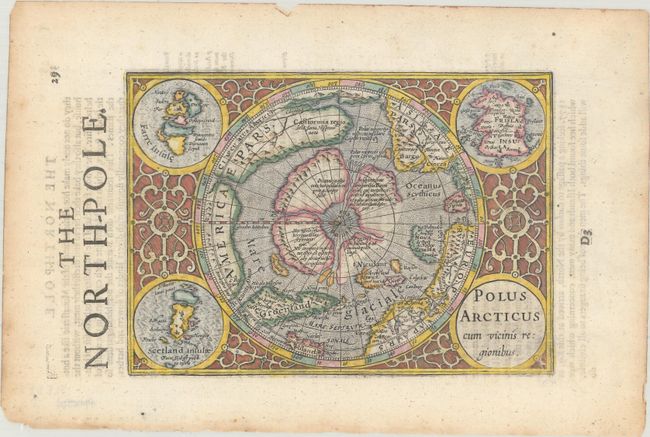
Subject: North Pole

Period: 1635 (published)

Publication: Historia Mundi or Mercators Atlas...

Color: Hand Color

Size:
7.4 x 5.3 inches
18.8 x 13.5 cm
Download High Resolution Image
(or just click on image to launch the Zoom viewer)

This is a reduced version of the second state of Mercator's famous North Pole map. It depicts the region between the pole and the Arctic Circle. This is one of the most intriguing early maps, combining medieval geographic concepts with some of the most advanced cartography of its day. The North Pole is shown as a rocky island surrounded by 'in-drawing seas' between four huge islands. The map shows an awareness of recent discoveries, including those of Frobisher and Davis, as well as the northern sea passage through America to Asia. It is a striking example of baroque engraving, with the map set off by the roundel title cartouche and inset maps of the Faeroes, the Shetlands, and the mythical Frisland in the corners, and framed by a border of interlocking acanthus designs.

This map comes from the English edition of Mercator's Atlas Minor, which was published under the title Historia Mundi or Mercators Atlas by Michael Spark and Samuel Cartwright. After acquiring the plates to the 1607 edition of the Mercator/Hondius Atlas Minor, Sparke republished the maps with text translated into English by Wye Saltonstall.

References: Burden #154; Kershaw #27; Van der Krogt (Vol. III) #0020:351.

Condition: A

A sharp impression with light toning along the edges of the sheet and a few tiny edge tears also along the edges.

Estimate: $400 - $475

Sold for: $350

Closed on 11/17/2021

Archived