Catalog Archive
Auction 185, Lot 124

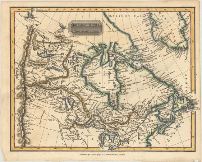
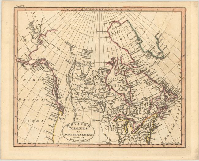
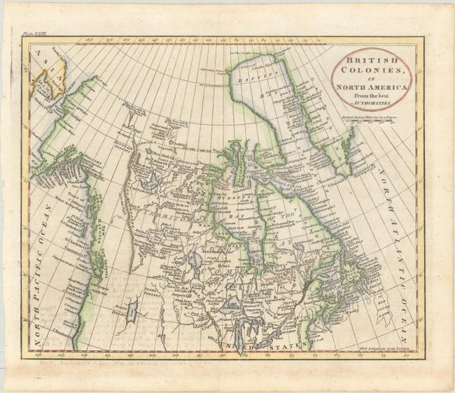
"[Lot of 3] British Colonies in North America [and] British Colonies, in North America; from the Best Authorities [and] British Colonies, in North America from the Best Authorities",

Subject: Canada & Northern United States

Period: 1797-1815 (circa)

Publication:

Color: Hand Color

Size:
See Description
Download High Resolution Image
(or just click on image to launch the Zoom viewer)

A. British Colonies in North America, by Thomas Kelly, circa 1815 (9.9 x 7.5"). This fascinating map details the English possessions east of the Rockies and north of Lake Erie, with most of the detail in Canada. There is nice detail of watershed, including the "supposed courses" of several western rivers branching off the Missouri. Notes in Canada indicate "The Sea seen by Hearne 1771," "The Sea seem by Mackenzie 1789," and "This River according to the Indians joins the Sea" (along it is not clear to which river it refers). Many Indian villages are identified. Condition: A crisp impression with minor soiling.

B. British Colonies, in North America; from the Best Authorities, by Anonymous, circa 1810 (9.0 x 7.4"). This very finely engraved map shows all of Canada and Alaska. The western reaches are blank but along the coast are labeled New Cornwall, New Hanover, and New Georgia. In the far north of Yukon is the notation "The Sea seen by Mr. McKenzie in 1789" and further east another says "The Sea seen by Mr. Hearn in 1771." It locates the Copper Indians and the Coppermine River. The entire northern coast is blank. The map hints at a Northwest Passage with a complex network of rivers; the key connection is delineated by dotted line. In Alaska the Aleutian chain is Alyaska, and the chart locates Cook's River, Prince Williams Sound, Mt. Elias, Bristol Bay, and Norton Sound. Kodiak Island is I. Kichtac. Other editions credit John Russell with drawing and engraving the map, but on this edition his imprint has been removed, although vague remnants can still be seen beneath the title cartouche. Condition: There is minor toning and light offsetting.

C. British Colonies, in North America from the Best Authorities, by Anonymous, circa 1797 (8.8 x 7.0"). This richly detailed small map of Canada extends to show Alaska and features many interesting notations throughout. New Cornwall, New Hanover, and New Georgia are named along the coast of present-day British Columbia. The Alaska Peninsula is labeled Alyaska, and Cook's River, Prince Williams Sound, Bristol Bay, and Norton Sound are all identified. Beyond the outer limits of Hearne and McKenzie's explorations, the map is blank. The University of British Columbia has an edition of this map with the same plate number (Plate XXIII), but with the imprints of engraver John Russell and the publishers (Published Novr. 21, 1797 by C. Dilly & G.G. & J. Robinson, London). Condition: Issued folding, now flat, with minor offsetting from an opposing page of text.

References:

Condition: A

See description above.

Estimate: $240 - $300

Sold for: $230

Closed on 11/17/2021

Archived