Catalog Archive
Auction 183, Lot 245

NO RESERVE

"A Hysterical Map of Yellowstone Park and the Jackson Hole Country Slightly Cockeyed",

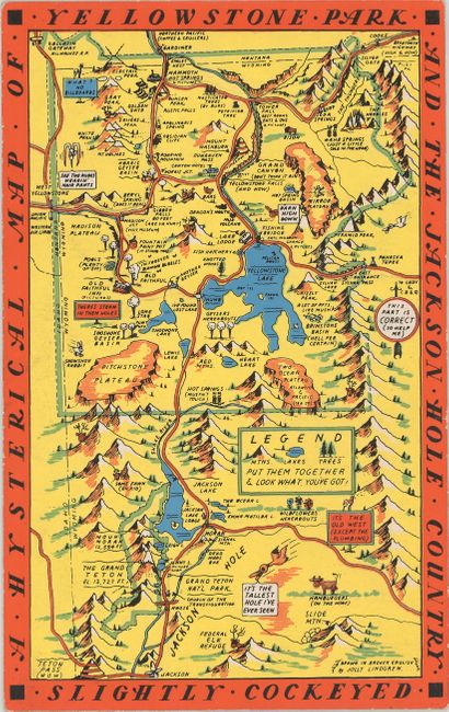
Subject: Yellowstone & Jackson Hole, Wyoming

Period: 1950 (circa)

Publication:

Color: Printed Color

Size:
5.4 x 8.6 inches
13.7 x 21.8 cm
Download High Resolution Image
(or just click on image to launch the Zoom viewer)

Visual puns and funny asides abound in this novelty map of Yellowstone National Park "drawn in broken English" by Jolly Lindgren. It extends to show the Jackson Hole valley and Grand Teton National Park. Examples of Lindgren's madcap humor include Electric Peak shown with lightning bolts crashing into its peak, Old Faithful doing a rendition of "I'm Forever Blowing Bubbles," hot springs depicted as coils radiating heat, and birds sitting upon signs reading "What? No Billboards" and "It's the Old West (Except the Plumbing)". A swooping bird regards Jackson Hole and quips, "It's the tallest hole I've ever seen," while below a caption identifies a cow as "Hamburgers (On the Hoof)." This map is printed on cardstock with "King Size Mapcard" printed on verso to allow tourists to mail this postcard to friends and family.

The Lindgren brothers of Spokane, Washington, specialized in humorous maps primarily of national parks. The brothers founded their business in 1928 with Hjalmer (Jolly) serving as the artist and Oscar (O.S.) overseeing administration and production. They produced their first map in 1932 - Hysterical Map of the Spokane Country Slightly Cockeyed - which was designed to be "hysterical" rather than "historical." Their comical map was successful, and in 1933 others followed, including Puget Sound, Rainier National Park and Yellowstone National Park. Despite the Great Depression, tourism in National Parks increased significantly in the 1930s, and visitors were eager for souvenirs of their trips. The Lindgren brothers capitalized on this trend, producing numerous National Park maps. Beginning with the Yellowstone map, Jolly developed a standardized format with a bold blue border incorporating the title, yellow denoting land (because of Yellowstone), red for roadways, black for text, and accents of green and blue. This style and color scheme became Jolly's signature style and was continued on all of his Hysterical maps of National Parks. The Lindgren brothers had hired Ted Turner as director of sales in 1930, and his role in the business gradually evolved until he became an official partner in 1949, and the business was renamed Lindgren-Turner. After World War II, the map business declined, so the Lindgrens and Turner innovated to create souvenir decals, which became hugely popular. After Jolly Lindgren's death in 1952, Oscar Lindgren and Ted Turner further extended the product line to include postcards (called "King Size Mapcard").

References: Clinton (IMCOS #125) pp. 27-39; Hornsby, p. 58.

Condition: A

A bright example with minor wear along the edges, lightly bumped corners, and some old ink markings on verso.

Estimate: $75 - $100

Sold for: $70

Closed on 6/9/2021

Archived