Catalog Archive
Auction 183, Lot 234

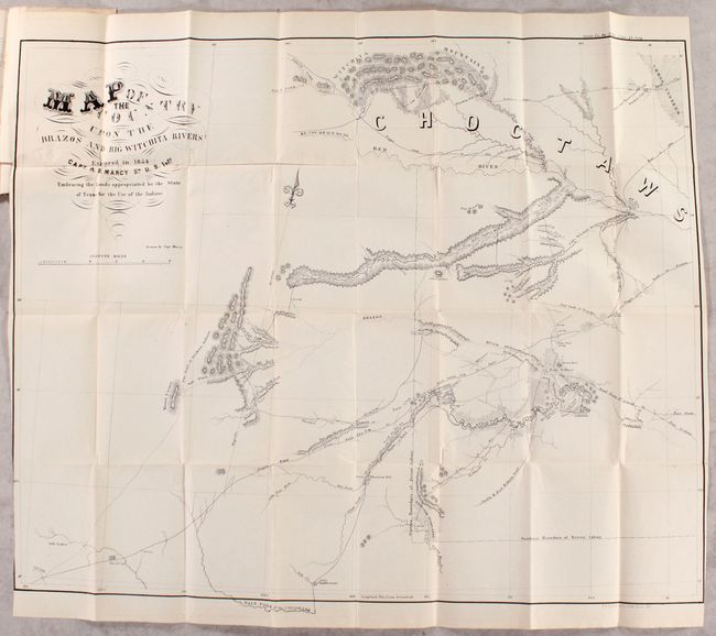
"[Map in Report] Map of the Country Upon the Brazos and Big Wichita Rivers Explored in 1854 by Capt. R.B. Marcy 5th U.S. Infy. Embracing the Lands Appropriated by the State of Texas for the Use of the Indians", Marcy, Capt. R.B.

Subject: Northeastern Texas, Oklahoma

Period: 1856 (published)

Publication: Sen. Doc. 60, 34th Congress, 1st Session

Color: Black & White

Size:
31.3 x 26.1 inches
79.5 x 66.3 cm
Download High Resolution Image
(or just click on image to launch the Zoom viewer)

This large and detailed map covers the northeastern part of Texas and a portion of Oklahoma, just north of the Red River, which is noted as Choctaw territory. Filled with details, it includes many place names, wagon roads, forts, reservations, woodlands, bayous, etc. Marcy explored this region in part to locate suitable lands for Indian settlement. Complete with Marcy's 48-page disbound report.

References: Wagner & Camp #278.

Condition: B+

The folding map is clean and bright and has been trimmed to just inside the border at bottom left by the binder. A 6" binding tear at top left has been closed on verso with archival tape. Text has light toning and scattered foxing.

Estimate: $350 - $425

Sold for: $220

Closed on 6/9/2021

Archived