Catalog Archive
Auction 182, Lot 743

A Cornerstone Piece in the Mapping of Australia and New Zealand

"Kaart der Reyse van Abel Tasman Volgens syn Eygen Opstel", Valentyn, Francois

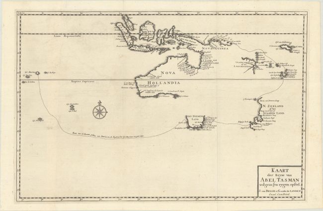
Subject: South Pacific Ocean, Australia, & New Zealand

Period: 1726 (published)

Publication: Oud en Nieuw Oost-Indien...

Color: Black & White

Size:
18.1 x 11.9 inches
46 x 30.2 cm
Download High Resolution Image
(or just click on image to launch the Zoom viewer)

This rare map is one of the earliest maps to center the newly discovered Australia. It is also the first printed map to completely delineate the first voyage of Abel Tasman in 1642-43, tracing his route from Mauritius to Batavia. One of Tasman's primary objectives was to explore the unknown Province of Beach, a presumed promontory of the great southern continent based on a mistake from Marco Polo's account. By circumnavigating Australia from a distance, Tasman was able to determine that it was not attached to the southern continent.

The map depicts the southern coast of Tasmania, named Van Diemens Land by Tasman after the Dutch colonial governor Antonio van Diemen. N. Zeeland of het Staaten Land is also depicted as an incomplete coastline with an anchorage in A. Tasmans Baey. Tasman and his crew were the first Europeans to sight New Zealand, which they believed to be the western edge of Terra Australis. While the map does not chart Tasman's second voyage in 1644, it does record his findings from that voyage along the northern coast of Australia. New Guinea has not fully taken shape and nearly connects to the Australian continent. The map also extends to show part of present-day peninsular Malaysia and Indonesia, naming Sumatra, Java, Borneo, and Celebes. A compass rose capped with fleur-de-lis adorns the sea. On 2 joined sheets. This map was published by Joannes van Braam and Gerard Onder de Linden in the third volume of Valentyn's Oud en Nieuw Oost Indien.

Valentyn was a prominent historian of the Dutch East India Company who is best known for Oud en Nieuw Oost Indien, his vast illustrated account of the Dutch trading empire in Asia. He twice traveled to the East Indies and served as Calvinist minister to Ambon between 1686 and 1694. In preparing this monumental work, he was given privileged access to the previously secret archives of the VOC, containing transcripts and copies of important earlier Dutch voyages.

References: Shirley (BL Atlases) G.VALN-1a #17; Tooley (Australia) p. 212 #69.

Condition: A

A dark impression issued folding on a sheet with a fleur-de-lis watermark. There is faint offsetting and a few minor spots in unengraved areas. The joint is partially separated at bottom.

Estimate: $6,000 - $7,500

Sold for: $5,000

Closed on 4/28/2021

Archived