Catalog Archive
Auction 182, Lot 695

Striking Early Map of Bali

"Kaart van het Eyland Bali", Valentyn, Francois

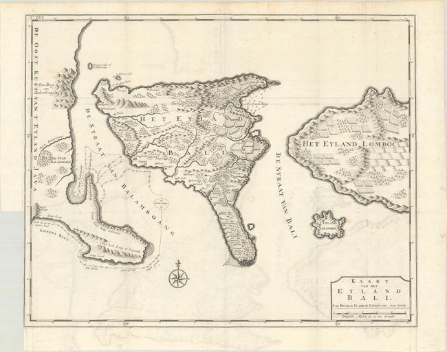
Subject: Bali, Indonesia

Period: 1726 (published)

Publication: Oud en Nieuw Oost-Indien...

Color: Black & White

Size:
22.1 x 17.7 inches
56.1 x 45 cm
Download High Resolution Image
(or just click on image to launch the Zoom viewer)

This is the first large map to focus on the Indonesian island of Bali. Based on the configuration of Lodewijcksz, it shows the mountainous island with numerous villages and cultivated fields on the eastern side with the adjacent coastlines of Java and Lombok. While the Dutch controlled much of the Indonesian archipelago during the seventeenth and eighteen centuries, Bali remained an independent kingdom that conducted trade with the Dutch in Jakarta. This map was published by Joannes van Braam and Gerard Onder de Linden in the third volume of Valentyn's Oud en Nieuw Oost Indien.

Valentyn was a prominent historian of the Dutch East India Company who is best known for Oud en Nieuw Oost Indien, his vast illustrated account of the Dutch trading empire in Asia. He twice traveled to the East Indies and served as Calvinist minister to Ambon between 1686 and 1694. In preparing this monumental work, he was given privileged access to the previously secret archives of the VOC, containing transcripts and copies of important earlier Dutch voyages.

References: Shirley (BL Atlases) G.VALN-1a #24.

Condition: B+

A dark impression issued folding with light offsetting, faint foxing, and a binding trim in the left blank margin extending to the neatline.

Estimate: $1,100 - $1,400

Sold for: $800

Closed on 4/28/2021

Archived