Catalog Archive
Auction 182, Lot 521

Jansson's Rare Carte-a-Figures Map of the German Empire in Contemporary Color

"Nova Germaniae Descriptio", Hondius/Jansson

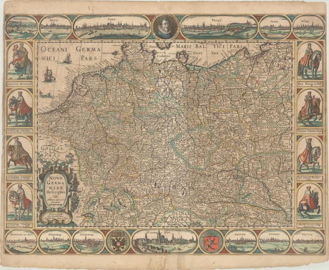
Subject: Central Europe, Germany

Period: 1632 (dated)

Publication: Gerardi Mercatoris et I. Hondii Atlas ofte Afbeeldinghe vande Gantsche Weerldt

Color: Hand Color

Size:
21.8 x 16.3 inches
55.4 x 41.4 cm
Download High Resolution Image
(or just click on image to launch the Zoom viewer)

This rare carte-a-figures map of the German Empire extends from the Low Countries to Prussia and from Holstein to northern Italy. It is dense with place names and topographical detail. Thirteen city views run across the top and bottom of the map, including Heidelberg, Mainz, Cologne, Prague, Speyer, Vienna, Frankfurt am Main, Nuremberg, Strasbourg, the Prague Castle (Kaiser's Hof), Augsburg, Erfurt, and Leipzig. A portrait of Ferdinand II, the Holy Roman Emperor at the time of the map's publication, appears at top center. The coats of arms of the Holy Roman Empire and Bohemia flank the castle at bottom. Along the sides there are vignettes of the Emperor and seven electors, all atop their horses. This map only appeared in two editions of the atlas. Dutch text on verso, published in 1634.

References: Van der Krogt (Vol. I) #2000:1C.1.

Condition: B

A nice impression and full contemporary color with some scattered foxing and light soiling. There are three edge tears at bottom, two of which enter the vignette of Prague Castle, which have been repaired on verso with archival materials. The margins are very narrow at right and left, trimmed to the neatline at top right by the bookbinder.

Estimate: $1,800 - $2,300

Sold for: $1,100

Closed on 4/28/2021

Archived