Catalog Archive
Auction 182, Lot 445

"A Map of the Bermudas or Somers Islands Discovered by Juan de Bermudez In or About the Year 1503...", Smith, J.L.
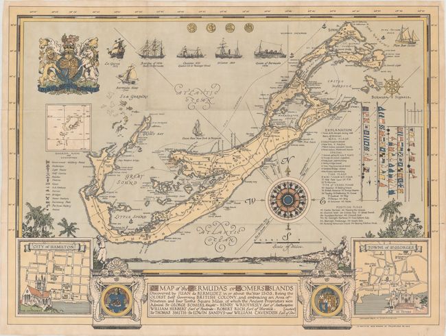
Subject: Bermuda

Period: 1934 (dated)

Publication:

Color: Printed Color

Size:
30.6 x 23 inches
77.7 x 58.4 cm
Download High Resolution Image
(or just click on image to launch the Zoom viewer)

This elegant and informative souvenir map of Bermuda was created by D. M. Kirkpartick. The title gives a very brief explanation of the European discovery and colonization of the island, flanked by the coats of arms of Bermuda and Great Britain, as well as inset plans of Hamilton and St. George's. The map includes a key identifying everything a tourist may need to know: military sites, anchorages, light houses, golf clubs, beaches, taverns, caves, tennis stadiums, swimming pools, hotels, and a perfume factory. At right is a key showing numerous flags with explanations of their meaning, and at top are coins and ships important to the history of Bermuda. Published by J.L. Smith Co.

Donald Morris Kirkpatrick (1887-1966) was a notable American architect, professor and artist. Born and raised in Pennsylvania, Kirkpatrick studied architecture and began a career in this field, earning numerous awards and accolades. After vacationing in Bermuda for his honeymoon and several other trips, Kirkpatrick and his wife moved to Bermuda in 1934. While he continued his work as an architect, he also branched out into art, creating numerous watercolors, many of which now reside in museums and art institutes. This map is one of two souvenir pictorial maps of Bermuda made by Kirkpatrick, with the second version published in 1947.

References:

Condition: B+

Issued folding, now flattened and professionally backed in thin, archival tissue to repair some short separations and holes along the folds, as well as a couple of minor tears. There is light soiling that is mostly concentrated at top center.

Estimate: $350 - $450

Sold for: $325

Closed on 4/28/2021

Archived