Catalog Archive
Auction 182, Lot 258

NO RESERVE

"A Plat Exhibiting the State of the Surveys in the Territory of Florida", U.S. Government

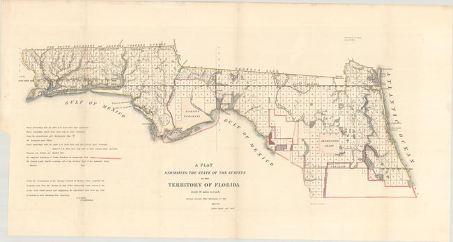
Subject: Northern Florida

Period: 1838 (dated)

Publication: Sen. Doc. 17 No. 9, 25th Congress 3rd Session

Color: Hand Color

Size:
22.5 x 9.5 inches
57.2 x 24.1 cm
Download High Resolution Image
(or just click on image to launch the Zoom viewer)

This map is one of the earliest to illustrate the status of public land surveys in the Eastern Land District (east of the Suwanee River) and the Western Land District (west of the Suwanee) in the Florida Panhandle. Survey efforts south of the Indian Boundary Line (marked in pink) in southern Florida were largely suspended due to the guerilla warfare of the ongoing Second Seminole War. St. Augustine, Amelia Island, and Tallahassee are named. The supposed boundary of the Forbes Purchase is designated in pink. From the Surveyors Office in Tallahassee by Robert Butler, Surveyor General for the Territory of Florida. A very early edition of this chart.

References:

Condition: B+

Issued folding with light toning along the folds at left and minor scattered foxing.

Estimate: $110 - $140

Unsold

Closed on 4/28/2021

Archived